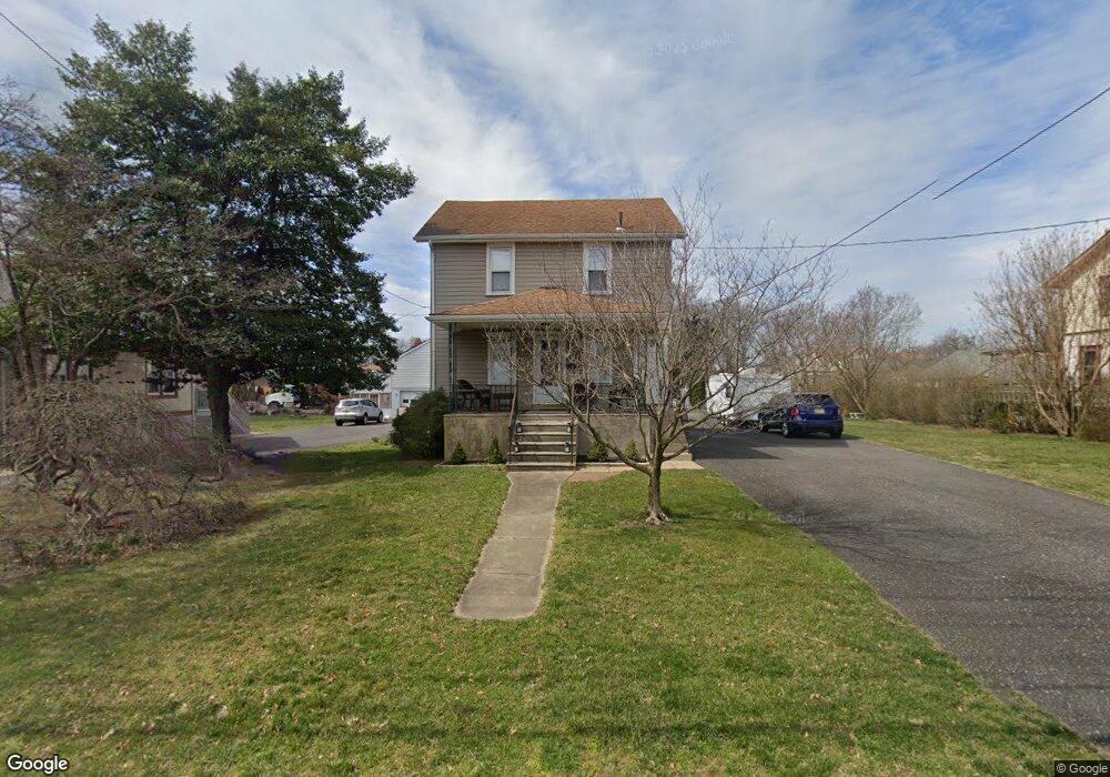
412 S Coles Ave Maple Shade, NJ 08052
Estimated Value: $292,000 - $359,000
--
Bed
--
Bath
1,708
Sq Ft
$192/Sq Ft
Est. Value
About This Home
This home is located at 412 S Coles Ave, Maple Shade, NJ 08052 and is currently estimated at $327,733, approximately $191 per square foot. 412 S Coles Ave is a home located in Burlington County with nearby schools including Maude M. Wilkins Elementary School, Ralph J Steinhauer Elementary School, and Howard R Yocum School.
Ownership History
Date
Name
Owned For
Owner Type
Purchase Details
Closed on
Dec 1, 2008
Sold by
Beatrice Dorothy
Bought by
Lannon Denise E and Lannon Kevin R
Current Estimated Value
Purchase Details
Closed on
Oct 14, 2005
Sold by
Clark William J and Kerns Dorothy Marie
Bought by
Beatrice Dorothy
Purchase Details
Closed on
Jan 27, 1994
Sold by
Macmacadams Charles Mac
Bought by
Greenlee Ruth E
Home Financials for this Owner
Home Financials are based on the most recent Mortgage that was taken out on this home.
Original Mortgage
$84,000
Interest Rate
7.15%
Create a Home Valuation Report for This Property
The Home Valuation Report is an in-depth analysis detailing your home's value as well as a comparison with similar homes in the area
Home Values in the Area
Average Home Value in this Area
Purchase History
| Date | Buyer | Sale Price | Title Company |
|---|---|---|---|
| Lannon Denise E | $150,000 | Surety Title Corporation | |
| Beatrice Dorothy | $100,000 | None Available | |
| Greenlee Ruth E | $87,500 | -- |
Source: Public Records
Mortgage History
| Date | Status | Borrower | Loan Amount |
|---|---|---|---|
| Previous Owner | Greenlee Ruth E | $84,000 |
Source: Public Records
Tax History Compared to Growth
Tax History
| Year | Tax Paid | Tax Assessment Tax Assessment Total Assessment is a certain percentage of the fair market value that is determined by local assessors to be the total taxable value of land and additions on the property. | Land | Improvement |
|---|---|---|---|---|
| 2025 | $7,554 | $199,000 | $48,000 | $151,000 |
| 2024 | $7,335 | $199,000 | $48,000 | $151,000 |
| 2023 | $7,335 | $199,000 | $48,000 | $151,000 |
| 2022 | $7,222 | $199,000 | $48,000 | $151,000 |
| 2021 | $7,140 | $199,000 | $48,000 | $151,000 |
| 2020 | $7,172 | $199,000 | $48,000 | $151,000 |
| 2019 | $6,909 | $199,000 | $48,000 | $151,000 |
| 2018 | $6,790 | $199,000 | $48,000 | $151,000 |
| 2017 | $6,710 | $199,000 | $48,000 | $151,000 |
| 2016 | $6,611 | $199,000 | $48,000 | $151,000 |
| 2015 | $6,468 | $199,000 | $48,000 | $151,000 |
| 2014 | $6,270 | $199,000 | $48,000 | $151,000 |
Source: Public Records
Map
Nearby Homes
- 327 S Coles Ave
- 32 Woodbine Ave
- 5 Paul Rd
- 19 Farnsworth Ave
- 477 Buttonwood Ave
- 524 W Main St
- 410 S Forklanding Rd
- 107 S Forklanding Rd
- 120 E Center Ave
- 480 W Front St
- 112 S Maple Ave
- 48 N Terrace Ave
- 50 Mara Ct
- 47 Mara Ct
- 111 Chestnut St Unit 113
- 111 Chestnut St Unit 404
- 406 Chestnut St
- 29 W Broadway
- 22 Theodore Ave
- 103 Lincoln Ave S
- 406 S Coles Ave
- 420 S Coles Ave
- 402 S Coles Ave
- 414 Florence Ave
- 426 S Coles Ave Unit 28
- 418 Florence Ave
- 419 Rynning Ave
- 415 Rynning Ave
- 328 S Coles Ave
- 422 Florence Ave
- 415 Florence Ave
- 331 S Coles Ave
- 324 S Coles Ave
- 427 Rynning Ave
- 426 Florence Ave
- 320 S Coles Ave
- 407 Florence Ave
- 418 Rynning Ave
- 323 S Coles Ave
- 316 S Coles Avenue 0