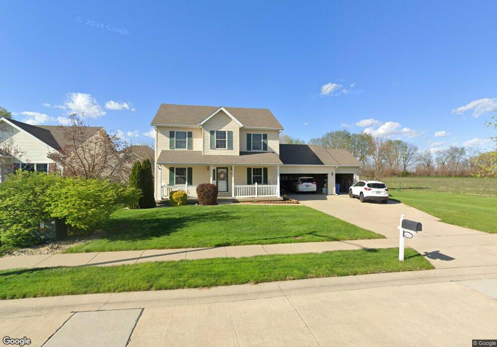
4121 Newtonmore Dr Springfield, IL 62712
Estimated Value: $294,986 - $337,000
3
Beds
3
Baths
1,971
Sq Ft
$164/Sq Ft
Est. Value
About This Home
This home is located at 4121 Newtonmore Dr, Springfield, IL 62712 and is currently estimated at $322,747, approximately $163 per square foot. 4121 Newtonmore Dr is a home located in Sangamon County with nearby schools including Rochester Elementary Ec-1 School, Rochester Elementary School, and Rochester Intermediate School.
Ownership History
Date
Name
Owned For
Owner Type
Purchase Details
Closed on
Dec 15, 2005
Current Estimated Value
Purchase Details
Closed on
Feb 1, 2005
Purchase Details
Closed on
Jan 6, 2005
Purchase Details
Closed on
Dec 22, 2004
Purchase Details
Closed on
Dec 3, 2004
Purchase Details
Closed on
Nov 23, 2004
Purchase Details
Closed on
Oct 15, 2004
Create a Home Valuation Report for This Property
The Home Valuation Report is an in-depth analysis detailing your home's value as well as a comparison with similar homes in the area
Purchase History
| Date | Buyer | Sale Price | Title Company |
|---|---|---|---|
| -- | -- | -- | |
| -- | -- | -- | |
| -- | -- | -- | |
| -- | -- | -- | |
| -- | -- | -- | |
| -- | -- | -- | |
| -- | -- | -- | |
| -- | $162,800 | -- |
Source: Public Records
Tax History
| Year | Tax Paid | Tax Assessment Tax Assessment Total Assessment is a certain percentage of the fair market value that is determined by local assessors to be the total taxable value of land and additions on the property. | Land | Improvement |
|---|---|---|---|---|
| 2024 | $6,064 | $91,123 | $15,934 | $75,189 |
| 2023 | $5,698 | $83,232 | $14,554 | $68,678 |
| 2022 | $5,434 | $78,454 | $13,806 | $64,648 |
| 2021 | $5,241 | $75,516 | $13,289 | $62,227 |
| 2020 | $5,209 | $75,629 | $13,309 | $62,320 |
| 2019 | $5,105 | $75,366 | $13,263 | $62,103 |
| 2018 | $4,884 | $71,680 | $13,198 | $58,482 |
| 2017 | $4,804 | $70,753 | $13,027 | $57,726 |
| 2016 | $4,737 | $69,721 | $12,837 | $56,884 |
| 2015 | $4,632 | $68,888 | $12,684 | $56,204 |
| 2014 | $4,406 | $68,443 | $12,602 | $55,841 |
| 2013 | $4,380 | $65,786 | $12,603 | $53,183 |
Source: Public Records
Map
Nearby Homes
- 2632 Hilltop Rd
- 66 White Birch Rd
- 53 Mishawaka Dr Unit 1
- 10 Lancelot Dr
- 35 Galahad Dr Unit 1
- 8 Riverwood Dr
- 65 Linden Ln
- 0 Oak Hill Rd
- 19 Circle Dr Unit 1
- 300 N Walnut St Unit 1
- 180 E Hazel Dell Unit 1
- 108 Glen Aire Dr
- 400 N Park St
- 2709 Carl Prairie Dr
- 2632 Steiler Place
- 501 Sattley St Unit 1
- 10 Radcliff Rd
- 2906 Taylor Ave Unit 11
- 2900 Taylor Ave Unit 4
- 3012 Taylor Ave Unit 58
- 4117 Newtonmore Dr
- 4136 Destiny Dr
- 4132 Destiny Dr
- 4113 Newtonmore Dr
- 4120 Newtonmore Dr
- 4116 Newtonmore Dr
- 4128 Destiny Dr
- 4109 Newtonmore Dr
- 4112 Newtonmore Dr
- 4124 Destiny Dr
- 4121 Blair Dr
- 4117 Blair Dr
- 4113 Blair Dr
- 4105 Newtonmore Dr
- 4129 Destiny Dr
- 4120 Destiny Dr
- 4109 Blair Dr
- 4125 Destiny Dr
- 4101 Newtonmore Dr
Your Personal Tour Guide
Ask me questions while you tour the home.