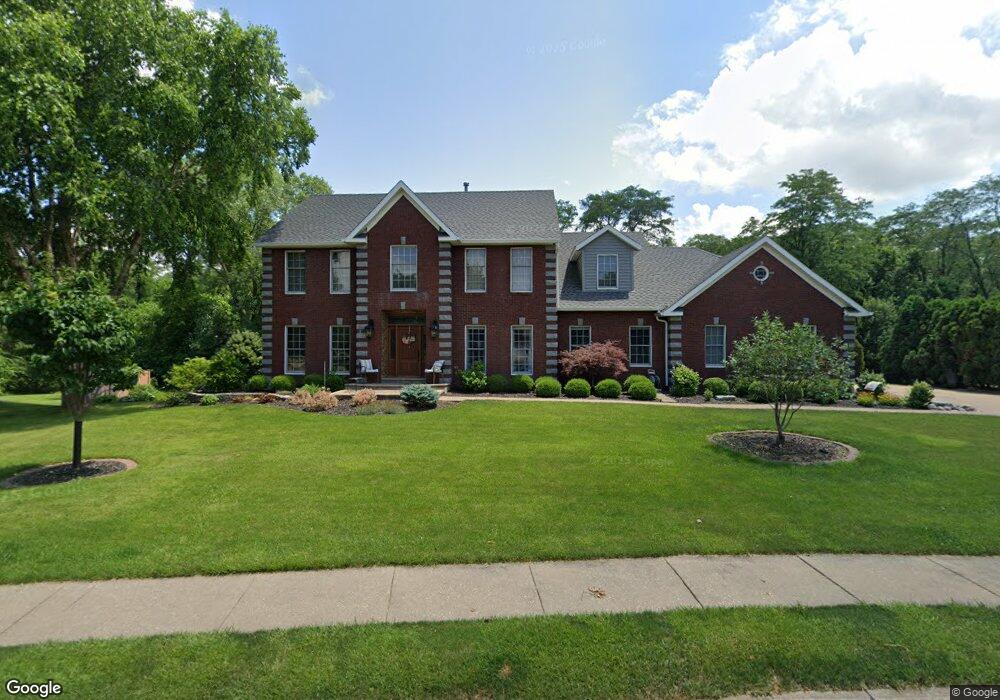
4131 Glendale Blvd Davenport, IA 52807
North Side NeighborhoodEstimated Value: $596,150 - $623,000
5
Beds
8
Baths
3,424
Sq Ft
$179/Sq Ft
Est. Value
About This Home
This home is located at 4131 Glendale Blvd, Davenport, IA 52807 and is currently estimated at $613,038, approximately $179 per square foot. 4131 Glendale Blvd is a home located in Scott County with nearby schools including Jones Park Elementary School, Eisenhower Elementary School, and Casey County Middle School.
Ownership History
Date
Name
Owned For
Owner Type
Purchase Details
Closed on
Jun 6, 2025
Sold by
Gary A Kleinschmidt A and Gary Cynthia L
Bought by
Ott Sarah and Ott Stephen
Current Estimated Value
Home Financials for this Owner
Home Financials are based on the most recent Mortgage that was taken out on this home.
Original Mortgage
$325,000
Outstanding Balance
$321,608
Interest Rate
5.92%
Mortgage Type
New Conventional
Estimated Equity
$291,430
Purchase Details
Closed on
Oct 14, 2024
Sold by
Kleinschmidt Gary A and Kleinschmidt Cynthia L
Bought by
Trust Agreement Created By Gary A Kleinschmid and Kleinschmidt
Create a Home Valuation Report for This Property
The Home Valuation Report is an in-depth analysis detailing your home's value as well as a comparison with similar homes in the area
Home Values in the Area
Average Home Value in this Area
Purchase History
| Date | Buyer | Sale Price | Title Company |
|---|---|---|---|
| Ott Sarah | $625,000 | None Listed On Document | |
| Trust Agreement Created By Gary A Kleinschmid | -- | None Listed On Document |
Source: Public Records
Mortgage History
| Date | Status | Borrower | Loan Amount |
|---|---|---|---|
| Open | Ott Sarah | $325,000 |
Source: Public Records
Tax History Compared to Growth
Tax History
| Year | Tax Paid | Tax Assessment Tax Assessment Total Assessment is a certain percentage of the fair market value that is determined by local assessors to be the total taxable value of land and additions on the property. | Land | Improvement |
|---|---|---|---|---|
| 2025 | $8,898 | $565,340 | $79,350 | $485,990 |
| 2024 | $8,682 | $497,850 | $79,350 | $418,500 |
| 2023 | $9,852 | $497,850 | $79,350 | $418,500 |
| 2022 | $9,898 | $461,220 | $71,790 | $389,430 |
| 2021 | $9,898 | $461,220 | $71,790 | $389,430 |
| 2020 | $9,266 | $426,520 | $71,790 | $354,730 |
| 2019 | $9,378 | $426,520 | $71,790 | $354,730 |
| 2018 | $9,176 | $426,520 | $71,790 | $354,730 |
| 2017 | $2,372 | $426,520 | $71,790 | $354,730 |
| 2016 | $8,786 | $409,870 | $0 | $0 |
| 2015 | $8,786 | $402,340 | $0 | $0 |
| 2014 | $8,742 | $402,340 | $0 | $0 |
| 2013 | $8,586 | $0 | $0 | $0 |
| 2012 | -- | $398,810 | $65,300 | $333,510 |
Source: Public Records
Map
Nearby Homes
- 2919 E 44th Ct
- 4005 Forest Rd
- 2924 E 45th Ct
- 2916 E 45th Ct
- 3000 E 32nd St Unit 14
- 3315 Fairhaven Rd
- 2506 E 35th Street Ct
- 2501 E 34th Street Ct
- 4230 Jersey Ridge Rd
- 2805 Carriage Hill Dr
- 4919 Lorton Ave
- 1120 Terrace Park Dr
- 2318 E 46th St
- 4554 Bunker Hill Dr
- 2321 E 47th St
- 2203 E 46th St
- 2586 E George Washington Blvd
- 2846 Magnolia Dr
- 1115 Spruce Hills Dr
- 1455 Prairie Vista Dr
- 4121 Glendale Blvd
- 4135 Glendale Blvd
- 4124 Glendale Blvd
- 4101 Glendale Blvd
- 4104 Glendale Blvd
- 4137 Glendale Blvd
- 2951 E 43rd St
- 2946 E 41st Ct
- 4011 Glendale Blvd
- 4301 Ryan Ct
- 4008 Glendale Blvd
- 4305 Ryan Ct
- 4309 Ryan Ct
- 2947 E 43rd St
- 2947 E 41st Ct
- 4007 Glendale Blvd
- 2938 E 41st Ct
- 2947 E 41st Ct
- 3940 Elmore Ave Unit 3
- 3940 Elmore Ave