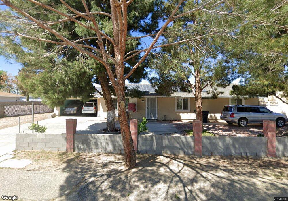
41379 159th St E Lancaster, CA 93535
Estimated Value: $362,000 - $377,000
4
Beds
2
Baths
1,300
Sq Ft
$282/Sq Ft
Est. Value
About This Home
This home is located at 41379 159th St E, Lancaster, CA 93535 and is currently estimated at $366,947, approximately $282 per square foot. 41379 159th St E is a home located in Los Angeles County with nearby schools including Challenger Middle School, Vista San Gabriel Elementary School, and Littlerock High School.
Ownership History
Date
Name
Owned For
Owner Type
Purchase Details
Closed on
Mar 11, 2011
Sold by
The Secretary Of Housing & Urban Develop
Bought by
Munoz Irene
Current Estimated Value
Purchase Details
Closed on
Sep 20, 2010
Sold by
Cenlar Fsb
Bought by
The Secretary Of Housing & Urban Develop
Purchase Details
Closed on
Sep 1, 2010
Sold by
Scruggs Carline
Bought by
Centar Fsb
Purchase Details
Closed on
Oct 29, 2002
Sold by
Mcdonald Michael Kane
Bought by
Scruggs Carline
Home Financials for this Owner
Home Financials are based on the most recent Mortgage that was taken out on this home.
Original Mortgage
$113,223
Interest Rate
6.06%
Mortgage Type
FHA
Purchase Details
Closed on
Aug 20, 2001
Sold by
Mcdonald Karri Lynn
Bought by
Mcdonald Michael Kane
Home Financials for this Owner
Home Financials are based on the most recent Mortgage that was taken out on this home.
Original Mortgage
$71,608
Interest Rate
7.21%
Mortgage Type
FHA
Purchase Details
Closed on
Feb 21, 1997
Sold by
Fingerhood Arnold Michael and Cornacchio Salvatore F
Bought by
Mcdonald Michael Kane
Home Financials for this Owner
Home Financials are based on the most recent Mortgage that was taken out on this home.
Original Mortgage
$48,650
Interest Rate
9.74%
Purchase Details
Closed on
Jun 25, 1996
Sold by
Sunderland Robert and Fingerhood Arnold Michael
Bought by
Fingerhood Arnold Michael and Cornacchio Salvatore F
Purchase Details
Closed on
Jun 1, 1994
Sold by
Cisnero Henry C
Bought by
Sunderland Robert
Home Financials for this Owner
Home Financials are based on the most recent Mortgage that was taken out on this home.
Original Mortgage
$40,000
Interest Rate
8.6%
Purchase Details
Closed on
May 27, 1994
Sold by
Sunderland Kristi
Bought by
Sunderland Robert
Home Financials for this Owner
Home Financials are based on the most recent Mortgage that was taken out on this home.
Original Mortgage
$40,000
Interest Rate
8.6%
Create a Home Valuation Report for This Property
The Home Valuation Report is an in-depth analysis detailing your home's value as well as a comparison with similar homes in the area
Home Values in the Area
Average Home Value in this Area
Purchase History
| Date | Buyer | Sale Price | Title Company |
|---|---|---|---|
| Munoz Irene | $63,500 | Pacific Coast Title Company | |
| The Secretary Of Housing & Urban Develop | -- | Lsi Title Company | |
| Centar Fsb | $117,197 | None Available | |
| Scruggs Carline | $109,000 | First American Title Co | |
| Mcdonald Michael Kane | -- | Chicago Title Co | |
| Mcdonald Michael Kane | $69,500 | Fidelity National Title Co | |
| Fingerhood Arnold Michael | $45,542 | -- | |
| Sunderland Robert | $36,000 | California Counties Title Co | |
| Sunderland Robert | -- | California Counties Title Co |
Source: Public Records
Mortgage History
| Date | Status | Borrower | Loan Amount |
|---|---|---|---|
| Previous Owner | Scruggs Carline | $113,223 | |
| Previous Owner | Mcdonald Michael Kane | $71,608 | |
| Previous Owner | Mcdonald Michael Kane | $48,650 | |
| Previous Owner | Sunderland Robert | $40,000 | |
| Closed | Mcdonald Michael Kane | $13,900 |
Source: Public Records
Tax History
| Year | Tax Paid | Tax Assessment Tax Assessment Total Assessment is a certain percentage of the fair market value that is determined by local assessors to be the total taxable value of land and additions on the property. | Land | Improvement |
|---|---|---|---|---|
| 2025 | $1,429 | $101,035 | $24,464 | $76,571 |
| 2024 | $1,429 | $99,055 | $23,985 | $75,070 |
| 2023 | $1,411 | $97,114 | $23,515 | $73,599 |
| 2022 | $1,390 | $95,210 | $23,054 | $72,156 |
| 2021 | $1,144 | $75,149 | $22,602 | $52,547 |
| 2019 | $1,108 | $72,923 | $21,933 | $50,990 |
| 2018 | $1,084 | $71,494 | $21,503 | $49,991 |
| 2016 | $1,013 | $68,719 | $20,669 | $48,050 |
| 2015 | $999 | $67,688 | $20,359 | $47,329 |
| 2014 | $1,015 | $66,363 | $19,961 | $46,402 |
Source: Public Records
Map
Nearby Homes
- 0 158 Ste Vic Lanfair Ave E Unit 238656
- 0 165th Ste Drt Vic Ave M
- 133 East Ave N
- 41331 156th St E
- 0 160th St E Unit IV26018473
- 8 162nd St E
- 41060 158th St E
- 16254 Mossdale Ave
- 0 East Ave N
- 15232 Greenrock Ave
- 40578 163rd St E
- 15142 Lanfair Ave
- 0 Cor 166th Unit Ste Drt
- 0 Vac Cor Avenue N Drt 166th Unit DRT 24-372887
- 18500 East Ave N
- 11200 East Ave N
- 16105 Newmont Ave
- 0 Avenue G-8 Unit SR24108855
- 0 Avenue G-8 Unit IG26020353
- 16173 Newmont Ave
- 41371 159th St E
- 41389 159th St E
- 41378 159th St E
- 41407 159th St E
- 41359 159th St E
- 41370 159th St E
- 41404 159th St E
- 41358 159th St E
- 41412 159th St E
- 41415 159th St E
- 41350 159th St E
- 41420 159th St E
- 41433 159th St E
- 41432 159th St E
- 41330 159th St E
- 0 Ave O & 152nd St E E Unit SR19132432
- 41442 159th St E
- 0 160th Ave N #Vic Unit 18005043
- 41450 159th St E
- 41315 159th St E
Your Personal Tour Guide
Ask me questions while you tour the home.