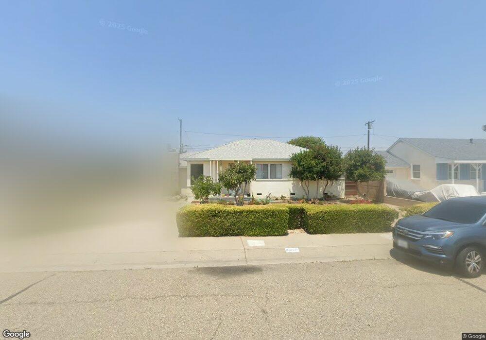
415 E Kamala St Oxnard, CA 93033
Cal-Gisler NeighborhoodEstimated Value: $612,247 - $858,000
3
Beds
1
Bath
972
Sq Ft
$730/Sq Ft
Est. Value
About This Home
This home is located at 415 E Kamala St, Oxnard, CA 93033 and is currently estimated at $709,312, approximately $729 per square foot. 415 E Kamala St is a home located in Ventura County with nearby schools including Harrington Elementary School, R.J. Frank Academy of Marine Science & Engineering, and Channel Islands High School.
Ownership History
Date
Name
Owned For
Owner Type
Purchase Details
Closed on
Jul 7, 2000
Sold by
Yukio Kobashigawa and Yukio Nancy M
Bought by
Kobashigawa Brian K
Current Estimated Value
Home Financials for this Owner
Home Financials are based on the most recent Mortgage that was taken out on this home.
Original Mortgage
$144,000
Interest Rate
8.2%
Create a Home Valuation Report for This Property
The Home Valuation Report is an in-depth analysis detailing your home's value as well as a comparison with similar homes in the area
Home Values in the Area
Average Home Value in this Area
Purchase History
| Date | Buyer | Sale Price | Title Company |
|---|---|---|---|
| Kobashigawa Brian K | $180,000 | Chicago Title Co |
Source: Public Records
Mortgage History
| Date | Status | Borrower | Loan Amount |
|---|---|---|---|
| Previous Owner | Kobashigawa Brian K | $144,000 |
Source: Public Records
Tax History
| Year | Tax Paid | Tax Assessment Tax Assessment Total Assessment is a certain percentage of the fair market value that is determined by local assessors to be the total taxable value of land and additions on the property. | Land | Improvement |
|---|---|---|---|---|
| 2025 | $655 | $50,139 | $18,328 | $31,811 |
| 2024 | $655 | $49,156 | $17,968 | $31,188 |
| 2023 | $632 | $48,193 | $17,616 | $30,577 |
| 2022 | $615 | $47,249 | $17,271 | $29,978 |
| 2021 | $610 | $46,323 | $16,932 | $29,391 |
| 2020 | $620 | $45,850 | $16,759 | $29,091 |
| 2019 | $604 | $44,952 | $16,431 | $28,521 |
| 2018 | $596 | $44,071 | $16,109 | $27,962 |
| 2017 | $568 | $43,208 | $15,794 | $27,414 |
| 2016 | $549 | $42,362 | $15,485 | $26,877 |
| 2015 | $555 | $41,727 | $15,253 | $26,474 |
| 2014 | $549 | $40,911 | $14,955 | $25,956 |
Source: Public Records
Map
Nearby Homes
- 225 W Iris St
- 430-440 W Linden Dr
- 1036 Cheyenne Way
- 2024 S J St
- 1425 S E St
- 1239 S C St
- 3631 La Costa Place
- 1127 S C St
- 360 Ibsen Place Unit 129
- 1928 San Benito St
- 4160 Petit Dr Unit 39
- 2151 E Wooley Rd
- 320 Columbia Place Unit 46
- 3630 Dallas Dr
- 1140 Teakwood St
- 775 Thayer Ln
- 1009 S G St
- 4200 S A St
- 633 Meta St
- 659 S A St
- 425 E Kamala St
- 405 E Kamala St
- 435 E Kamala St
- 363 E Kamala St
- 414 E Juniper St
- 404 E Juniper St
- 424 E Juniper St
- 414 E Kamala St
- 404 E Kamala St
- 424 E Kamala St
- 364 E Juniper St
- 434 E Juniper St
- 445 E Kamala St
- 355 E Kamala St
- 434 E Kamala St
- 362 E Kamala St
- 354 E Juniper St
- 444 E Juniper St
- 444 E Kamala St
- 354 E Kamala St
Your Personal Tour Guide
Ask me questions while you tour the home.