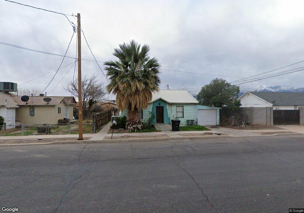
415 W 4th St Safford, AZ 85546
Estimated Value: $46,179 - $161,000
--
Bed
--
Bath
480
Sq Ft
$199/Sq Ft
Est. Value
About This Home
This home is located at 415 W 4th St, Safford, AZ 85546 and is currently estimated at $95,726, approximately $199 per square foot. 415 W 4th St is a home located in Graham County with nearby schools including Ruth Powell Elementary School, Dorothy Stinson School, and Lafe Nelson School.
Ownership History
Date
Name
Owned For
Owner Type
Purchase Details
Closed on
Dec 13, 2023
Sold by
Keith and Caroldeene Mcbride
Bought by
Adam D Hoopes And Stephanie L Hoopes Living T and Hoopes
Current Estimated Value
Purchase Details
Closed on
Dec 6, 2023
Sold by
Keith and Caroldeene Mcbride
Bought by
Adam D Hoopes And Stephanie L Hoopes Living T and Hoopes
Purchase Details
Closed on
May 26, 2005
Sold by
Decker Heidi
Bought by
Decker Edwin Kent
Create a Home Valuation Report for This Property
The Home Valuation Report is an in-depth analysis detailing your home's value as well as a comparison with similar homes in the area
Home Values in the Area
Average Home Value in this Area
Purchase History
| Date | Buyer | Sale Price | Title Company |
|---|---|---|---|
| Adam D Hoopes And Stephanie L Hoopes Living T | -- | None Listed On Document | |
| Adam D Hoopes And Stephanie L Hoopes Living T | -- | None Listed On Document | |
| Decker Edwin Kent | -- | Safford Title Agency | |
| Decker Edwin Herbst | $9,500 | Safford Title Agency |
Source: Public Records
Tax History Compared to Growth
Tax History
| Year | Tax Paid | Tax Assessment Tax Assessment Total Assessment is a certain percentage of the fair market value that is determined by local assessors to be the total taxable value of land and additions on the property. | Land | Improvement |
|---|---|---|---|---|
| 2026 | $132 | -- | -- | -- |
| 2025 | $132 | $3,847 | $443 | $3,404 |
| 2024 | $139 | $3,691 | $443 | $3,248 |
| 2023 | $139 | $3,130 | $443 | $2,687 |
| 2022 | $136 | $2,723 | $443 | $2,280 |
| 2021 | $146 | $0 | $0 | $0 |
| 2020 | $141 | $0 | $0 | $0 |
| 2019 | $147 | $0 | $0 | $0 |
| 2018 | $141 | $0 | $0 | $0 |
| 2017 | $112 | $0 | $0 | $0 |
| 2016 | $113 | $0 | $0 | $0 |
| 2015 | $110 | $0 | $0 | $0 |
Source: Public Records
Map
Nearby Homes
- 216 S 6th Ave
- 616 W 7th St
- 818 W 7th St Unit A
- 1104 S Central Ave
- 1116 S 6th Ave
- 1204 S 1st Ave
- 1108 S 9th Ave
- 1101 S 9th Place
- 1210 S 1st Ave
- 120 Relation St Unit 2
- 813 W 13th St
- 1309 S Bingham Place
- 115 W 15th St
- 1544 Stone Willow Dr
- 1115 W Relation St
- 603 W 16th St
- 1536 W Cherokee Ln
- 860 S Flagstone Way
- 1609 S 12th Ave
- 832 W Stirrup Dr
- 415 W 4th St
- 402 S Central Ave
- 404 S Central Ave
- 418 W 4th St
- 318 S Central Ave
- 314 S Central Ave
- 422 W 4th St
- 322 S Central Ave
- 502 W 4th St
- 315 S 5th Ave
- 406 S 5th Ave
- 504 W 4th St
- 306 S Central Ave
- 411 & 405 W 5th St
- 501 S 5th Ave
- 506 W 4th St
- 520 W 5th St
- 520 W 5th St
- 303 S 5th Ave
- 310 S 5th Ave