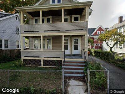
42 Royal St Unit 42A Allston, MA 02134
Allston NeighborhoodEstimated Value: $1,163,000 - $1,395,000
5
Beds
2
Baths
2,416
Sq Ft
$527/Sq Ft
Est. Value
About This Home
This home is located at 42 Royal St Unit 42A, Allston, MA 02134 and is currently estimated at $1,274,016, approximately $527 per square foot. 42 Royal St Unit 42A is a home located in Suffolk County with nearby schools including German International School Boston and St Herman Of Alaska Christian School.
Ownership History
Date
Name
Owned For
Owner Type
Purchase Details
Closed on
Dec 11, 1992
Sold by
Dimare Mario
Bought by
Ferrante Richard D
Current Estimated Value
Home Financials for this Owner
Home Financials are based on the most recent Mortgage that was taken out on this home.
Original Mortgage
$124,200
Interest Rate
8.16%
Mortgage Type
Purchase Money Mortgage
Create a Home Valuation Report for This Property
The Home Valuation Report is an in-depth analysis detailing your home's value as well as a comparison with similar homes in the area
Home Values in the Area
Average Home Value in this Area
Purchase History
| Date | Buyer | Sale Price | Title Company |
|---|---|---|---|
| Ferrante Richard D | $138,000 | -- |
Source: Public Records
Mortgage History
| Date | Status | Borrower | Loan Amount |
|---|---|---|---|
| Open | Ferrante Richard D | $108,300 | |
| Closed | Ferrante Richard D | $124,200 |
Source: Public Records
Tax History Compared to Growth
Tax History
| Year | Tax Paid | Tax Assessment Tax Assessment Total Assessment is a certain percentage of the fair market value that is determined by local assessors to be the total taxable value of land and additions on the property. | Land | Improvement |
|---|---|---|---|---|
| 2025 | $14,220 | $1,228,000 | $467,900 | $760,100 |
| 2024 | $12,365 | $1,134,400 | $267,300 | $867,100 |
| 2023 | $11,490 | $1,069,800 | $252,100 | $817,700 |
| 2022 | $10,980 | $1,009,200 | $237,800 | $771,400 |
| 2021 | $10,768 | $1,009,200 | $237,800 | $771,400 |
| 2020 | $8,536 | $808,300 | $221,200 | $587,100 |
| 2019 | $7,961 | $755,300 | $163,100 | $592,200 |
| 2018 | $7,328 | $699,200 | $163,100 | $536,100 |
| 2017 | $7,259 | $685,500 | $163,100 | $522,400 |
| 2016 | $6,557 | $596,100 | $163,100 | $433,000 |
| 2015 | $6,266 | $517,400 | $158,800 | $358,600 |
| 2014 | $5,657 | $449,700 | $158,800 | $290,900 |
Source: Public Records
Map
Nearby Homes
- 11-13 Mansfield St Unit 3
- 25 Bradbury St
- 19-19A Haskell St
- 31 Haskell St
- 16 Easton St
- 4 Franklin St Unit 401
- 4 Franklin St Unit 302
- 4 Franklin St Unit 303
- 4 Franklin St Unit 203
- 4 Franklin St Unit 402
- 4 Franklin St Unit 403
- 4 Franklin St Unit 201
- 4 Franklin St Unit 202
- 32 Adamson St Unit E
- 166-168 Franklin St
- 35 Adamson St
- 20 Penniman Rd Unit 101
- 30 Penniman Rd Unit 505
- 10 Windom St
- 22-24 Westford St
- 42 Royal St Unit 42A
- 46 Royal St Unit 48
- 38 Royal St
- 27 Mansfield St Unit 29
- 25 Mansfield St Unit 4
- 25 Mansfield St Unit 1
- 25 Mansfield St Unit 3
- 31 Mansfield St Unit 33
- 31 Mansfield St Unit 1-02
- 31 Mansfield St
- 50 Royal St Unit 52
- 37 Royal St Unit 39
- 37 Royal St Unit 2
- 34 Royal St
- 34 Royal St Unit 1
- 34 Royal St
- 34 Royal St Unit house
- 43 Royal St
- 23 Mansfield St
- 35 Mansfield St Unit 1