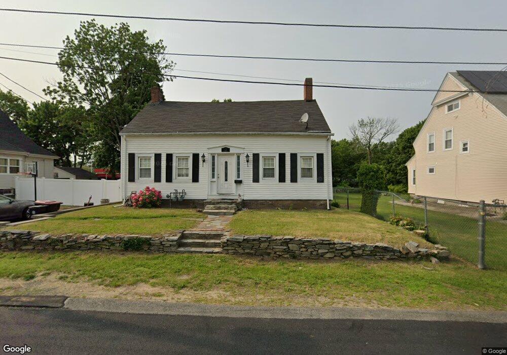
42 Watson St Brockton, MA 02301
Campello NeighborhoodEstimated Value: $458,000 - $546,000
2
Beds
1
Bath
1,754
Sq Ft
$282/Sq Ft
Est. Value
About This Home
This home is located at 42 Watson St, Brockton, MA 02301 and is currently estimated at $494,779, approximately $282 per square foot. 42 Watson St is a home located in Plymouth County with nearby schools including Gilmore Elementary School, Davis K-8 School, and John F. Kennedy Elementary School.
Ownership History
Date
Name
Owned For
Owner Type
Purchase Details
Closed on
Oct 28, 2021
Sold by
Araque Tara M
Bought by
Pires Joanna
Current Estimated Value
Home Financials for this Owner
Home Financials are based on the most recent Mortgage that was taken out on this home.
Original Mortgage
$351,037
Outstanding Balance
$320,807
Interest Rate
2.8%
Mortgage Type
FHA
Estimated Equity
$173,972
Purchase Details
Closed on
Mar 11, 2005
Sold by
Travers Stanley R and Travers Dorothy R
Bought by
Araque Tara M
Purchase Details
Closed on
Mar 29, 1988
Sold by
Bennett Theodore A
Bought by
Travers Stanley R
Home Financials for this Owner
Home Financials are based on the most recent Mortgage that was taken out on this home.
Original Mortgage
$52,500
Interest Rate
9.82%
Mortgage Type
Purchase Money Mortgage
Create a Home Valuation Report for This Property
The Home Valuation Report is an in-depth analysis detailing your home's value as well as a comparison with similar homes in the area
Home Values in the Area
Average Home Value in this Area
Purchase History
| Date | Buyer | Sale Price | Title Company |
|---|---|---|---|
| Pires Joanna | $360,000 | None Available | |
| Araque Tara M | -- | -- | |
| Travers Stanley R | $70,000 | -- |
Source: Public Records
Mortgage History
| Date | Status | Borrower | Loan Amount |
|---|---|---|---|
| Open | Pires Joanna | $351,037 | |
| Previous Owner | Travers Stanley R | $80,000 | |
| Previous Owner | Travers Stanley R | $52,500 |
Source: Public Records
Tax History Compared to Growth
Tax History
| Year | Tax Paid | Tax Assessment Tax Assessment Total Assessment is a certain percentage of the fair market value that is determined by local assessors to be the total taxable value of land and additions on the property. | Land | Improvement |
|---|---|---|---|---|
| 2025 | $4,412 | $364,300 | $140,000 | $224,300 |
| 2024 | $4,250 | $353,600 | $140,000 | $213,600 |
| 2023 | $4,320 | $332,800 | $104,100 | $228,700 |
| 2022 | $4,152 | $297,200 | $94,600 | $202,600 |
| 2021 | $3,821 | $263,500 | $78,500 | $185,000 |
| 2020 | $3,804 | $251,100 | $73,600 | $177,500 |
| 2019 | $3,598 | $231,500 | $71,800 | $159,700 |
| 2018 | $3,808 | $204,200 | $71,800 | $132,400 |
| 2017 | $3,046 | $189,200 | $71,800 | $117,400 |
| 2016 | $3,130 | $180,300 | $69,600 | $110,700 |
| 2015 | $2,514 | $138,500 | $69,600 | $68,900 |
| 2014 | $2,536 | $139,900 | $69,600 | $70,300 |
Source: Public Records
Map
Nearby Homes
- 15 Otto St
- 40 Glen Ave
- 163 S Leyden St
- 60 Clifton Ave
- 29 Glendale Ave
- 223 Clinton St Unit 10
- 223 Clinton St Unit 3
- 1845 Main St
- 358 Copeland St
- 115 Market St
- 47 Southworth St
- 44 Country Club Dr
- 13 Finny's Way
- 94 Carl Ave
- 112 Hillside Ave
- 34 Carl Ave
- 103 Clinton St
- 122 Sinclair Rd
- 12 Paulin Ave
- 936 Warren Ave
- 34 Watson St
- 46 Watson St
- 30 Watson St
- 39 Watson St
- 39 Watson St Unit 2
- 39 Watson St Unit 1
- 26 Watson St
- 45 Watson St
- 35 Watson St
- 54 Watson St
- 29 Watson St
- 24 Watson St
- 51 Watson St
- 18 Watson St
- 20 Watson St Unit 2
- 20 Watson St Unit 1
- 18 Watson St Unit 3
- 18 Watson St Unit 2
- 38 Holmes St
- 19 Watson St