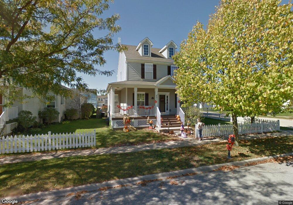
421 Reagan Dr Oswego, IL 60543
Northwest Oswego NeighborhoodEstimated Value: $317,000 - $357,000
3
Beds
3
Baths
1,655
Sq Ft
$204/Sq Ft
Est. Value
About This Home
This home is located at 421 Reagan Dr, Oswego, IL 60543 and is currently estimated at $337,270, approximately $203 per square foot. 421 Reagan Dr is a home located in Kendall County with nearby schools including Fox Chase Elementary School, Traughber Junior High School, and Oswego High School.
Ownership History
Date
Name
Owned For
Owner Type
Purchase Details
Closed on
May 24, 2004
Sold by
Madl Michael and Madl Michelle
Bought by
Lee Michael
Current Estimated Value
Home Financials for this Owner
Home Financials are based on the most recent Mortgage that was taken out on this home.
Original Mortgage
$207,074
Outstanding Balance
$99,880
Interest Rate
5.91%
Mortgage Type
FHA
Estimated Equity
$237,390
Purchase Details
Closed on
Sep 24, 1998
Sold by
Hometown Development Inc
Bought by
Madl Michael and Madl Michelle C
Home Financials for this Owner
Home Financials are based on the most recent Mortgage that was taken out on this home.
Original Mortgage
$137,800
Interest Rate
6.98%
Create a Home Valuation Report for This Property
The Home Valuation Report is an in-depth analysis detailing your home's value as well as a comparison with similar homes in the area
Home Values in the Area
Average Home Value in this Area
Purchase History
| Date | Buyer | Sale Price | Title Company |
|---|---|---|---|
| Lee Michael | $210,000 | Chicago Title Insurance Co | |
| Madl Michael | $172,500 | Ticor Title Insurance |
Source: Public Records
Mortgage History
| Date | Status | Borrower | Loan Amount |
|---|---|---|---|
| Open | Lee Michael | $207,074 | |
| Previous Owner | Madl Michael | $137,800 |
Source: Public Records
Tax History Compared to Growth
Tax History
| Year | Tax Paid | Tax Assessment Tax Assessment Total Assessment is a certain percentage of the fair market value that is determined by local assessors to be the total taxable value of land and additions on the property. | Land | Improvement |
|---|---|---|---|---|
| 2024 | $7,002 | $93,005 | $21,615 | $71,390 |
| 2023 | $6,277 | $82,305 | $19,128 | $63,177 |
| 2022 | $6,277 | $75,510 | $17,549 | $57,961 |
| 2021 | $6,232 | $72,606 | $16,874 | $55,732 |
| 2020 | $6,094 | $70,492 | $16,383 | $54,109 |
| 2019 | $5,851 | $66,952 | $16,383 | $50,569 |
| 2018 | $5,318 | $60,947 | $14,914 | $46,033 |
| 2017 | $5,143 | $56,173 | $13,746 | $42,427 |
| 2016 | $4,914 | $53,244 | $13,029 | $40,215 |
| 2015 | $4,723 | $49,300 | $12,064 | $37,236 |
| 2014 | -- | $46,509 | $11,381 | $35,128 |
| 2013 | -- | $48,422 | $11,849 | $36,573 |
Source: Public Records
Map
Nearby Homes
- 338 Millstream Ln Unit 1
- 514 Bentson St
- 125 Presidential Blvd Unit 3248
- 505 Parkland Ct
- 602 Clearwater Ct Unit 2
- 608 Clearwater Ct
- 411 Bayberry Dr
- 403 Lake Ct
- 238 Willowwood Dr
- 537 Arbor Ln
- 5055 U S 34
- 114 Riverview Ct
- 435 Fawn Dr
- 409 Fawn Dr
- 2350 State Route 31
- 123 W Benton St
- 613 Murdock Place
- 388 Danforth Dr
- 423 Hathaway Ln
- 610 Murdock Place
- 419 Reagan Dr
- 417 Reagan Dr
- 128 Eisenhower Dr
- 130 Eisenhower Dr
- 114 Eisenhower Dr
- 117 Eisenhower Dr Unit 1
- 132 Eisenhower Dr
- 119 Eisenhower Dr
- 415 Reagan Dr
- 121 Eisenhower Dr
- 227 Presidential Blvd
- 134 Eisenhower Dr
- 112 Eisenhower Dr
- 422 Reagan Dr Unit 1
- 413 Reagan Dr
- 123 Eisenhower Dr
- 225 Presidential Blvd
- 136 Eisenhower Dr
- 110 Eisenhower Dr
- 327 Millstream Ln