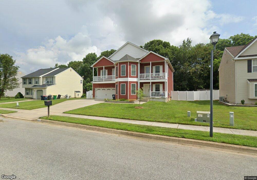
421 Weston Dr Middletown, DE 19709
Estimated Value: $454,000 - $597,601
4
Beds
3
Baths
2,740
Sq Ft
$192/Sq Ft
Est. Value
About This Home
This home is located at 421 Weston Dr, Middletown, DE 19709 and is currently estimated at $526,650, approximately $192 per square foot. 421 Weston Dr is a home located in New Castle County with nearby schools including Silver Lake Elementary School, Louis L. Redding Middle School, and Middletown High School.
Ownership History
Date
Name
Owned For
Owner Type
Purchase Details
Closed on
Dec 30, 2005
Sold by
Romero Samuel J
Bought by
Dawson Sean W and Dawson Elizabeth R
Current Estimated Value
Home Financials for this Owner
Home Financials are based on the most recent Mortgage that was taken out on this home.
Original Mortgage
$299,000
Outstanding Balance
$169,252
Interest Rate
6.39%
Mortgage Type
Fannie Mae Freddie Mac
Estimated Equity
$357,398
Purchase Details
Closed on
Jul 23, 2001
Sold by
Greenlawn Llc
Bought by
Romero Samuel J
Home Financials for this Owner
Home Financials are based on the most recent Mortgage that was taken out on this home.
Original Mortgage
$127,678
Interest Rate
7.2%
Create a Home Valuation Report for This Property
The Home Valuation Report is an in-depth analysis detailing your home's value as well as a comparison with similar homes in the area
Home Values in the Area
Average Home Value in this Area
Purchase History
| Date | Buyer | Sale Price | Title Company |
|---|---|---|---|
| Dawson Sean W | $299,000 | None Available | |
| Romero Samuel J | $154,950 | Ticor Title Insurance |
Source: Public Records
Mortgage History
| Date | Status | Borrower | Loan Amount |
|---|---|---|---|
| Open | Dawson Sean W | $299,000 | |
| Previous Owner | Romero Samuel J | $127,678 | |
| Closed | Romero Samuel J | $31,919 |
Source: Public Records
Tax History Compared to Growth
Tax History
| Year | Tax Paid | Tax Assessment Tax Assessment Total Assessment is a certain percentage of the fair market value that is determined by local assessors to be the total taxable value of land and additions on the property. | Land | Improvement |
|---|---|---|---|---|
| 2024 | $3,580 | $97,200 | $11,700 | $85,500 |
| 2023 | $292 | $97,200 | $11,700 | $85,500 |
| 2022 | $2,989 | $97,200 | $11,700 | $85,500 |
| 2021 | $2,923 | $97,200 | $11,700 | $85,500 |
| 2020 | $2,889 | $97,200 | $11,700 | $85,500 |
| 2019 | $2,968 | $97,200 | $11,700 | $85,500 |
| 2018 | $2,562 | $97,200 | $11,700 | $85,500 |
| 2017 | $2,466 | $97,200 | $11,700 | $85,500 |
| 2016 | $2,161 | $94,800 | $11,700 | $83,100 |
| 2015 | $293 | $94,800 | $11,700 | $83,100 |
| 2014 | $1,627 | $74,000 | $11,700 | $62,300 |
Source: Public Records
Map
Nearby Homes
- 335 Marldale Dr
- 6 Kimberly Dr
- 506 New St
- 65 W Sarazen Dr
- 12 Demaret Ct
- 47 Franklin Dr
- 309 New St
- 120 Betsy Rawls Dr
- 14 W Lake St
- 620 Village Dr Unit A620
- 434 Spring Hollow Dr
- 300 Hostetter Blvd
- 601 Village Dr
- 336 Hostetter Blvd
- 732 Cleaver Farm Rd
- 636 Poets Way
- 240 Main St
- The Easton Plan at The Grove at Bayberry
- The Wyatt Plan at The Grove at Bayberry
- The Brooks Plan at The Grove at Bayberry