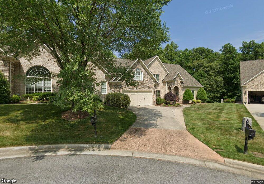
4217 Pennfield Way High Point, NC 27262
Estimated Value: $510,000 - $585,000
4
Beds
3
Baths
2,670
Sq Ft
$208/Sq Ft
Est. Value
About This Home
This home is located at 4217 Pennfield Way, High Point, NC 27262 and is currently estimated at $554,329, approximately $207 per square foot. 4217 Pennfield Way is a home located in Davidson County with nearby schools including Friendship Elementary School, Ledford Middle School, and Ledford High School.
Ownership History
Date
Name
Owned For
Owner Type
Purchase Details
Closed on
Nov 25, 2009
Sold by
Suntrust Bank
Bought by
Bryant Glenn Jeffery and Bryant Mary Marlene
Current Estimated Value
Home Financials for this Owner
Home Financials are based on the most recent Mortgage that was taken out on this home.
Original Mortgage
$188,000
Outstanding Balance
$122,876
Interest Rate
4.94%
Mortgage Type
New Conventional
Estimated Equity
$431,453
Purchase Details
Closed on
May 19, 2008
Sold by
Avondale Homes Inc
Bought by
Suntrust Bank
Create a Home Valuation Report for This Property
The Home Valuation Report is an in-depth analysis detailing your home's value as well as a comparison with similar homes in the area
Purchase History
| Date | Buyer | Sale Price | Title Company |
|---|---|---|---|
| Bryant Glenn Jeffery | $235,000 | None Available | |
| Suntrust Bank | $274,000 | None Available |
Source: Public Records
Mortgage History
| Date | Status | Borrower | Loan Amount |
|---|---|---|---|
| Open | Bryant Glenn Jeffery | $188,000 |
Source: Public Records
Tax History
| Year | Tax Paid | Tax Assessment Tax Assessment Total Assessment is a certain percentage of the fair market value that is determined by local assessors to be the total taxable value of land and additions on the property. | Land | Improvement |
|---|---|---|---|---|
| 2025 | $4,277 | $365,660 | $0 | $0 |
| 2024 | $4,277 | $365,660 | $0 | $0 |
| 2023 | $4,169 | $365,660 | $0 | $0 |
| 2022 | $4,169 | $365,660 | $0 | $0 |
| 2021 | $4,277 | $365,660 | $0 | $0 |
| 2020 | $3,779 | $323,080 | $0 | $0 |
| 2019 | $3,837 | $323,080 | $0 | $0 |
| 2018 | $3,837 | $323,080 | $0 | $0 |
| 2017 | $3,837 | $323,080 | $0 | $0 |
| 2016 | $3,837 | $323,080 | $0 | $0 |
| 2015 | $3,845 | $323,080 | $0 | $0 |
| 2014 | $4,265 | $354,260 | $0 | $0 |
Source: Public Records
Map
Nearby Homes
- 2729 Croquet Cir
- 2731 Croquet Cir
- 2801 Swan Lake Dr
- 1706 Windsor Dr
- 4095 Stallion St
- 4095 Stallion St Unit Lot 19
- 4106 Stallion St Unit Lot 78
- 4094 Stallion St Unit lot 75
- 4090 Stallion St Unit Lot 74
- 4244 Canter Creek Ln Unit 96
- 1625 Appaloosa Place Unit Lot 12
- 2925 Fernley Ct
- 2929 Fernley Ct
- 4091 Stallion St Unit Lot 20
- 4098 Stallion St Unit Lot 76
- 246 Merry Hills Dr
- 317 Canterbury Rd
- 1312 Gilbrook Ct
- 1200 Devlin Ct
- 1307 Gilbrook Ct
- 4215 Pennfield Way
- 4219 Pennfield Way
- 4221 Pennfield Way
- 2739 Croquet Cir
- 4218 Pennfield Way
- 2737 Croquet Cir
- 4214 Pennfield Way
- 4226 Lupton Ct
- 2735 Croquet Cir
- 4210 Pennfield Way
- 2733 Croquet Cir
- 4207 Pennfield Way
- 2728 Croquet Cir
- 4220 Lupton Ct
- 4206 Pennfield Way
- 4205 Pennfield Way
- 4214 Lupton Ct
- 4204 Pennfield Way
- 4234 Lupton Ct
- 2725 Croquet Cir
Your Personal Tour Guide
Ask me questions while you tour the home.