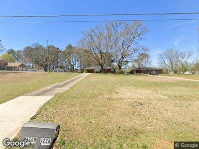
4228 Ewing Rd Austell, GA 30106
Estimated Value: $210,000 - $238,000
2
Beds
1
Bath
1,075
Sq Ft
$207/Sq Ft
Est. Value
About This Home
This home is located at 4228 Ewing Rd, Austell, GA 30106 and is currently estimated at $222,411, approximately $206 per square foot. 4228 Ewing Rd is a home located in Cobb County with nearby schools including Clarkdale Elementary School, Cooper Middle School, and Cumberland Christian Academy PK-12.
Ownership History
Date
Name
Owned For
Owner Type
Purchase Details
Closed on
Jul 25, 2024
Sold by
Arrington Brian W
Bought by
Hackney Michael Brian
Current Estimated Value
Purchase Details
Closed on
Jul 9, 2007
Sold by
Walker Jimmie R
Bought by
Arrington Brian W
Home Financials for this Owner
Home Financials are based on the most recent Mortgage that was taken out on this home.
Original Mortgage
$88,200
Interest Rate
6.56%
Mortgage Type
New Conventional
Purchase Details
Closed on
Jul 1, 1997
Sold by
Roberts Grady H and Roberts Joyce A
Bought by
Hackney James E and Hackney Clata R
Create a Home Valuation Report for This Property
The Home Valuation Report is an in-depth analysis detailing your home's value as well as a comparison with similar homes in the area
Home Values in the Area
Average Home Value in this Area
Purchase History
| Date | Buyer | Sale Price | Title Company |
|---|---|---|---|
| Hackney Michael Brian | $205,000 | None Listed On Document | |
| Arrington Brian W | $98,000 | -- | |
| Hackney James E | $65,000 | -- |
Source: Public Records
Mortgage History
| Date | Status | Borrower | Loan Amount |
|---|---|---|---|
| Previous Owner | Arrington Brian | $51,064 | |
| Previous Owner | Arrington Brian Wayne | $108,000 | |
| Previous Owner | Arrington Brian W | $85,575 | |
| Previous Owner | Arrington Brian W | $88,200 |
Source: Public Records
Tax History Compared to Growth
Tax History
| Year | Tax Paid | Tax Assessment Tax Assessment Total Assessment is a certain percentage of the fair market value that is determined by local assessors to be the total taxable value of land and additions on the property. | Land | Improvement |
|---|---|---|---|---|
| 2024 | $2,040 | $67,660 | $35,328 | $32,332 |
| 2023 | $1,795 | $59,552 | $33,120 | $26,432 |
| 2022 | $1,472 | $48,512 | $22,080 | $26,432 |
| 2021 | $1,128 | $37,160 | $16,560 | $20,600 |
| 2020 | $1,128 | $37,160 | $16,560 | $20,600 |
| 2019 | $1,038 | $34,216 | $13,616 | $20,600 |
| 2018 | $949 | $31,256 | $12,512 | $18,744 |
| 2017 | $793 | $27,576 | $8,832 | $18,744 |
| 2016 | $793 | $27,576 | $8,832 | $18,744 |
| 2015 | $812 | $27,576 | $8,832 | $18,744 |
| 2014 | $662 | $22,280 | $0 | $0 |
Source: Public Records
Map
Nearby Homes
- 4246 Chestnut Grove Ln
- 4290 Chestnut Grove Ln
- 4024 Broadmoor Ct SW
- 2100 Baywood Blvd SW
- 3989 Flint Hill Rd
- 2828 Marksman Trail
- 2918 Pavia Cir
- 3832 Abbott Ln Unit 1
- 3916 Abbott Way Unit 2
- 4598 Flint Hill Rd
- 2539 Dogwood Hills Ct
- 3206 Abbott Dr Unit 12
- 3219 Abbott Dr Unit 5
- 4805 Madison Point Cir
- 4643 Wesley Dr
- 2415 Wales Dr
- 3722 Lockerbie Ln
- 3717 Lockerbie Ln
- 4228 Ewing Rd
- 4208 Ewing Rd
- 4260 Ewing Rd
- 4166 Ewing Rd
- 4229 Chestnut Grove Ln
- 4239 Chestnut Grove Ln
- 4106 Bunker Dr SW
- 4110 Bunker Dr SW
- 4114 Bunker Dr SW
- 4249 Chestnut Grove Ln
- 4102 Bunker Dr SW
- 4164 Ewing Rd
- 4118 Bunker Dr SW
- 4118 Bunker Dr SW
- 4257 Chestnut Grove Ln
- 4267 Ewing Rd
- 4272 Ewing Rd
- 435 Sumac Dr
- 4204 Plumtree Way
- 4122 Bunker Dr SW
