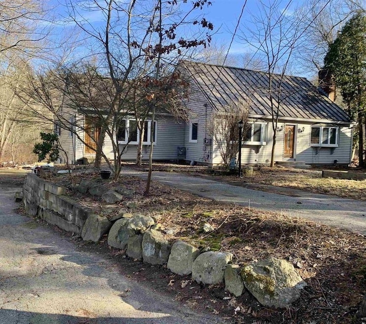
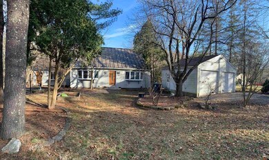
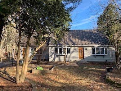
424 Main Dunstable Rd Nashua, NH 03062
Southwest Nashua NeighborhoodEstimated payment $3,067/month
Highlights
- 1.83 Acre Lot
- Wood Flooring
- 2 Car Garage
- Cape Cod Architecture
- Hot Water Heating System
About This Home
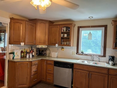
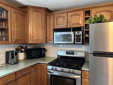
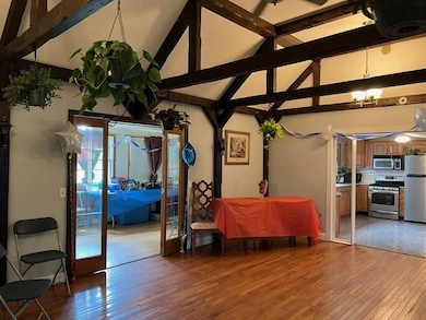
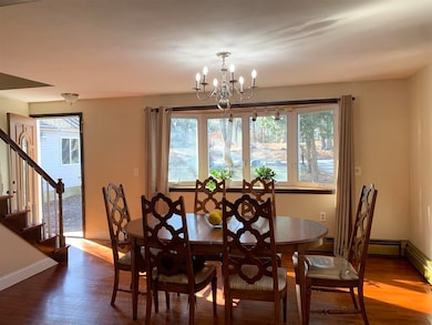
Opportunity abounds. This 4-bedroom expanded cape is priced below assessed value and has much to offer with even more potential. There’s a first-floor primary suite, an updated kitchen with all new stainless appliances and fresh flooring. Additionally there’s a full walk-out finished basement having its own separate entrance and driveway. Outside there is a huge private backyard including extra acreage with potential for additional usage. Bring your ideas and personality and it will add so much value to this hidden gem. Home to be sold "As is, as shown" Motivated seller for quick close.
Listing Agent
EXP Realty Brokerage Phone: 603-620-4391 License #056008 Listed on: 06/04/2025

Home Details
Home Type
- Single Family
Est. Annual Taxes
- $8,411
Year Built
- Built in 1969
Lot Details
- 1.83 Acre Lot
- Property is zoned R30
Parking
- 2 Car Garage
- Driveway
Home Design
- Cape Cod Architecture
- Wood Frame Construction
- Metal Roof
Interior Spaces
- Property has 2 Levels
- Wood Flooring
Bedrooms and Bathrooms
- 4 Bedrooms
Finished Basement
- Walk-Out Basement
- Basement Fills Entire Space Under The House
Utilities
- Hot Water Heating System
Listing and Financial Details
- Legal Lot and Block 772 / 424
- Assessor Parcel Number 4
Map
Home Values in the Area
Average Home Value in this Area
Tax History
| Year | Tax Paid | Tax Assessment Tax Assessment Total Assessment is a certain percentage of the fair market value that is determined by local assessors to be the total taxable value of land and additions on the property. | Land | Improvement |
|---|---|---|---|---|
| 2024 | $8,855 | $556,900 | $194,000 | $362,900 |
| 2023 | $8,411 | $461,400 | $155,200 | $306,200 |
| 2022 | $8,337 | $461,400 | $155,200 | $306,200 |
| 2021 | $7,906 | $340,500 | $108,800 | $231,700 |
| 2020 | $7,699 | $340,500 | $108,800 | $231,700 |
| 2019 | $7,409 | $340,500 | $108,800 | $231,700 |
| 2018 | $7,222 | $340,500 | $108,800 | $231,700 |
| 2017 | $6,680 | $259,000 | $94,900 | $164,100 |
| 2016 | $6,493 | $259,000 | $94,900 | $164,100 |
| 2015 | $6,339 | $258,400 | $94,900 | $163,500 |
| 2014 | $6,215 | $258,400 | $94,900 | $163,500 |
Property History
| Date | Event | Price | List to Sale | Price per Sq Ft |
|---|---|---|---|---|
| 10/16/2025 10/16/25 | Pending | -- | -- | -- |
| 10/13/2025 10/13/25 | Price Changed | $449,900 | -9.8% | $163 / Sq Ft |
| 10/09/2025 10/09/25 | For Sale | $499,000 | 0.0% | $180 / Sq Ft |
| 08/13/2025 08/13/25 | Off Market | $499,000 | -- | -- |
| 08/13/2025 08/13/25 | For Sale | $499,000 | 0.0% | $180 / Sq Ft |
| 07/23/2025 07/23/25 | Off Market | $499,000 | -- | -- |
| 07/23/2025 07/23/25 | For Sale | $499,000 | -9.1% | $180 / Sq Ft |
| 06/23/2025 06/23/25 | Off Market | $549,000 | -- | -- |
| 06/04/2025 06/04/25 | For Sale | $549,000 | -- | $198 / Sq Ft |
Purchase History
| Date | Type | Sale Price | Title Company |
|---|---|---|---|
| Quit Claim Deed | -- | None Available | |
| Quit Claim Deed | -- | None Available |
Source: PrimeMLS
MLS Number: 5044716
APN: NASH-000000-000000-000772C
Disclaimer: Certain information contained herein is derived from information provided by parties other than Homes.com. All information provided is deemed reliable, but is not guaranteed to be accurate and should be independently verified.
![]() Copyright 2025 PrimeMLS, Inc. All rights reserved. This information is deemed reliable, but not guaranteed. The data relating to real estate displayed on this display comes in part from the IDX Program of PrimeMLS. The information being provided is for consumers’ personal, non-commercial use and may not be used for any purpose other than to identify prospective properties consumers may be interested in purchasing.
Copyright 2025 PrimeMLS, Inc. All rights reserved. This information is deemed reliable, but not guaranteed. The data relating to real estate displayed on this display comes in part from the IDX Program of PrimeMLS. The information being provided is for consumers’ personal, non-commercial use and may not be used for any purpose other than to identify prospective properties consumers may be interested in purchasing.
- 2 Rene Dr
- 7 Roderick Cir
- 25 Cortez Dr Unit U57
- 5 Wilderness Dr
- 22 Newburgh Rd
- 3 Pluto Ln
- 58 Tanglewood Dr
- 130 Searles Rd
- 24 Yarmouth Dr
- 42 Woodfield St
- 5 Pasture Ln
- 4 Chesapeake Rd
- 5 Iris Ct Unit U147
- 12 Spring Cove Rd Unit U103
- 4 Henry David Dr Unit 203
- 47 Dogwood Dr Unit U202
- 500 Candlewood Park Unit 21
- 40 Spring Cove Rd Unit U117
- 33 Cannon Dr
- 31 Spring Cove Rd Unit U148