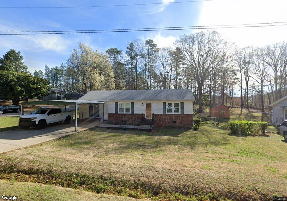
4243 White Way Dr Austell, GA 30106
Estimated Value: $240,000 - $322,000
3
Beds
2
Baths
1,440
Sq Ft
$189/Sq Ft
Est. Value
About This Home
This home is located at 4243 White Way Dr, Austell, GA 30106 and is currently estimated at $272,101, approximately $188 per square foot. 4243 White Way Dr is a home located in Cobb County with nearby schools including Deerwood Elementary School, Sunrise Elementary School, and Sanders Elementary School.
Ownership History
Date
Name
Owned For
Owner Type
Purchase Details
Closed on
Sep 19, 2023
Sold by
Tillison Cheryl A and Cook Selena G
Bought by
Tillison Family Trust and Cook
Current Estimated Value
Purchase Details
Closed on
Apr 4, 2011
Sold by
Tillison Cheryl A
Bought by
Tillison Cheryl A and Cook Selena
Purchase Details
Closed on
Aug 16, 2007
Sold by
Tillison Bobby R
Bought by
Tillison Bobby R and Tillison Cheryl A
Purchase Details
Closed on
Jul 11, 2007
Sold by
Tillison Bobby Ray
Bought by
Tillison Bobby R and Tillison Cheryl A
Create a Home Valuation Report for This Property
The Home Valuation Report is an in-depth analysis detailing your home's value as well as a comparison with similar homes in the area
Home Values in the Area
Average Home Value in this Area
Purchase History
| Date | Buyer | Sale Price | Title Company |
|---|---|---|---|
| Tillison Family Trust | -- | None Listed On Document | |
| Tillison Cheryl A | -- | -- | |
| Tillison Bobby R | -- | -- | |
| Tillison Bobby R | -- | -- |
Source: Public Records
Tax History Compared to Growth
Tax History
| Year | Tax Paid | Tax Assessment Tax Assessment Total Assessment is a certain percentage of the fair market value that is determined by local assessors to be the total taxable value of land and additions on the property. | Land | Improvement |
|---|---|---|---|---|
| 2025 | $2,164 | $90,800 | $28,000 | $62,800 |
| 2024 | $393 | $110,660 | $24,000 | $86,660 |
| 2023 | $112 | $55,324 | $12,000 | $43,324 |
| 2022 | $227 | $55,324 | $12,000 | $43,324 |
| 2021 | $227 | $55,324 | $12,000 | $43,324 |
| 2020 | $227 | $55,324 | $12,000 | $43,324 |
| 2019 | $209 | $49,260 | $12,000 | $37,260 |
| 2018 | $152 | $30,292 | $6,000 | $24,292 |
| 2017 | $143 | $30,292 | $6,000 | $24,292 |
| 2016 | $145 | $30,292 | $6,000 | $24,292 |
| 2015 | $155 | $30,292 | $6,000 | $24,292 |
| 2014 | $181 | $37,680 | $0 | $0 |
Source: Public Records
Map
Nearby Homes
- 4349 Kousa Rd Unit 4
- 1791 Fairview Dr SW
- 4200 Citizen Cir Unit 3
- 4470 Austell Rd
- 2013 Chesley Dr
- 2034 Drennon Ave
- 2081 Lenoa Ln
- 2083 Lenoa Ln
- 1984 Padgett Dr
- 2085 Lenoa Ln
- 4192 Rhinehart Dr
- 4582 Austell Rd
- 4406 Yelverton Place
- 4201 Regal Ridge Rd
- 2072 Mcduffie Rd
- 4420 Pink Rose Ct
- 1146 Silvergate Ln
- 3755 Mulkey Cir SW
- 4253 White Way Dr
- 1748 Orange Hill Dr
- 1758 Orange Hill Dr
- 4263 White Way Dr
- 1738 Orange Hill Dr
- 4260 White Way Dr
- 1768 Orange Hill Dr
- 0 Orange Hill Dr
- 0 White Way Dr Unit 7316192
- 0 White Way Dr Unit 8808877
- 0 White Way Dr
- 4273 White Way Dr Unit 4273
- 4273 White Way Dr
- 4273 White Way Dr
- 4273 White Way Dr
- 1778 Orange Hill Dr
- 4283 White Way Dr
- 1787 Orange Hill Dr
- 4280 White Way Dr
- 4290 White Way Dr