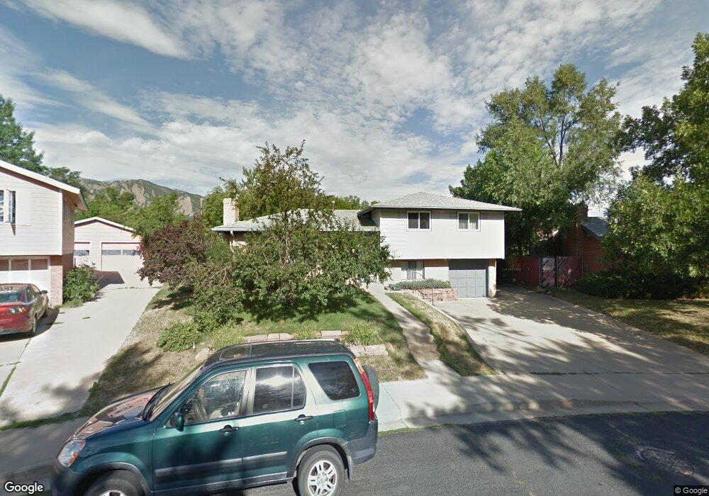
4266 Graham Ct Boulder, CO 80305
South Boulder NeighborhoodEstimated Value: $830,000 - $893,000
3
Beds
2
Baths
1,342
Sq Ft
$643/Sq Ft
Est. Value
About This Home
This home is located at 4266 Graham Ct, Boulder, CO 80305 and is currently estimated at $862,307, approximately $642 per square foot. 4266 Graham Ct is a home located in Boulder County with nearby schools including Creekside Elementary School, Manhattan Middle School of the Arts & Academics, and Fairview High School.
Ownership History
Date
Name
Owned For
Owner Type
Purchase Details
Closed on
May 11, 2024
Sold by
Ralph Day Living Trust
Bought by
Day Ralph and Day Alec
Current Estimated Value
Purchase Details
Closed on
Nov 2, 2020
Sold by
Day Ralph
Bought by
Day Ralph and Ralph Day Living Trust
Purchase Details
Closed on
Mar 13, 2015
Sold by
Ito Robert D and Estate Of Ritsu Yanagi Ito
Bought by
Day Alec
Home Financials for this Owner
Home Financials are based on the most recent Mortgage that was taken out on this home.
Original Mortgage
$344,000
Interest Rate
3.68%
Mortgage Type
New Conventional
Purchase Details
Closed on
Oct 28, 1986
Bought by
Day Alec and Day Ralph
Purchase Details
Closed on
Jan 25, 1985
Bought by
Day Alec and Day Ralph
Purchase Details
Closed on
Jan 7, 1977
Bought by
Day Alec and Day Ralph
Create a Home Valuation Report for This Property
The Home Valuation Report is an in-depth analysis detailing your home's value as well as a comparison with similar homes in the area
Home Values in the Area
Average Home Value in this Area
Purchase History
| Date | Buyer | Sale Price | Title Company |
|---|---|---|---|
| Day Ralph | -- | None Listed On Document | |
| Day Ralph | -- | None Available | |
| Day Alec | $430,000 | Land Title Guarantee Company | |
| Day Alec | $102,000 | -- | |
| Day Alec | $94,000 | -- | |
| Day Alec | $45,000 | -- |
Source: Public Records
Mortgage History
| Date | Status | Borrower | Loan Amount |
|---|---|---|---|
| Previous Owner | Day Alec | $344,000 |
Source: Public Records
Tax History
| Year | Tax Paid | Tax Assessment Tax Assessment Total Assessment is a certain percentage of the fair market value that is determined by local assessors to be the total taxable value of land and additions on the property. | Land | Improvement |
|---|---|---|---|---|
| 2025 | $4,950 | $51,600 | $42,956 | $8,644 |
| 2024 | $4,950 | $51,600 | $42,956 | $8,644 |
| 2023 | $4,861 | $55,422 | $50,337 | $8,770 |
| 2022 | $4,429 | $46,884 | $37,335 | $9,549 |
| 2021 | $4,227 | $48,234 | $38,410 | $9,824 |
| 2020 | $3,997 | $45,917 | $31,317 | $14,600 |
| 2019 | $3,936 | $45,917 | $31,317 | $14,600 |
| 2018 | $3,696 | $42,624 | $28,872 | $13,752 |
| 2017 | $3,580 | $47,124 | $31,920 | $15,204 |
| 2016 | $3,285 | $37,945 | $20,059 | $17,886 |
| 2015 | $2,458 | $31,092 | $15,920 | $15,172 |
| 2014 | $1,945 | $31,092 | $15,920 | $15,172 |
Source: Public Records
Map
Nearby Homes
- 405 S 43rd St
- 4595 Moorhead Ave
- 375 S 40th St
- 265 S 39th St
- 4835 Moorhead Ave
- 345 S 38th St
- 15 Pawnee Dr
- 4521 Navajo Place
- 725 S 45th St
- 230 Pawnee Dr
- 4763 Tantra Dr Unit B
- 755 W Moorhead Cir Unit B
- 4800 Osage Dr Unit B-16
- 750 W Moorhead Cir Unit A
- 800 W Moorhead Cir Unit E
- 860 W Moorhead Cir Unit 1I
- 860 W Moorhead Cir Unit 2H
- 3505 Moorhead Ave
- 3200 Eastman Ave
- 80 S 33rd St
Your Personal Tour Guide
Ask me questions while you tour the home.