Estimated Value: $276,000 - $303,000
3
Beds
2
Baths
1,410
Sq Ft
$202/Sq Ft
Est. Value
About This Home
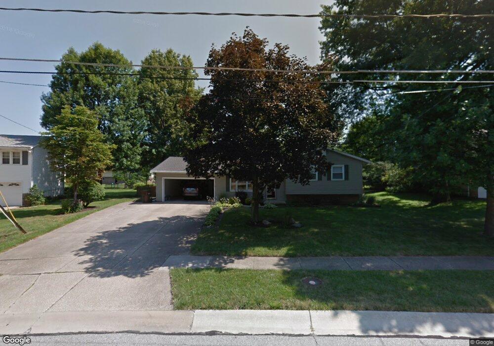
This home is located at 4289 Brixton Dr, Stow, OH 44224 and is currently estimated at $284,649, approximately $201 per square foot. 4289 Brixton Dr is a home located in Summit County with nearby schools including Stow-Munroe Falls High School, Holy Family Elementary School, and Walsh Jesuit High School.
Ownership History
Date
Name
Owned For
Owner Type
Purchase Details
Closed on
Aug 29, 2006
Sold by
Reese Tom E and Reese Janet L
Bought by
Stanley Mark and Stanley Ashlee D
Current Estimated Value
Home Financials for this Owner
Home Financials are based on the most recent Mortgage that was taken out on this home.
Original Mortgage
$126,400
Outstanding Balance
$75,454
Interest Rate
6.75%
Mortgage Type
Purchase Money Mortgage
Estimated Equity
$209,195
Create a Home Valuation Report for This Property
The Home Valuation Report is an in-depth analysis detailing your home's value as well as a comparison with similar homes in the area
Home Values in the Area
Average Home Value in this Area
Purchase History
| Date | Buyer | Sale Price | Title Company |
|---|---|---|---|
| Stanley Mark | $158,000 | Lake Erie Title Agency Inc |
Source: Public Records
Mortgage History
| Date | Status | Borrower | Loan Amount |
|---|---|---|---|
| Open | Stanley Mark | $126,400 |
Source: Public Records
Tax History
| Year | Tax Paid | Tax Assessment Tax Assessment Total Assessment is a certain percentage of the fair market value that is determined by local assessors to be the total taxable value of land and additions on the property. | Land | Improvement |
|---|---|---|---|---|
| 2024 | $4,204 | $74,393 | $12,856 | $61,537 |
| 2023 | $4,204 | $74,393 | $12,856 | $61,537 |
| 2022 | $3,594 | $56,056 | $9,667 | $46,389 |
| 2021 | $3,219 | $56,056 | $9,667 | $46,389 |
| 2020 | $3,164 | $56,060 | $9,670 | $46,390 |
| 2019 | $3,079 | $50,980 | $10,590 | $40,390 |
| 2018 | $3,029 | $50,980 | $10,590 | $40,390 |
| 2017 | $2,893 | $50,980 | $10,590 | $40,390 |
| 2016 | $2,978 | $47,300 | $10,590 | $36,710 |
| 2015 | $2,893 | $47,300 | $10,590 | $36,710 |
| 2014 | $2,896 | $47,300 | $10,590 | $36,710 |
| 2013 | $2,888 | $47,470 | $10,590 | $36,880 |
Source: Public Records
Map
Nearby Homes
- 2365 Norman Dr
- 4155 Burton Dr
- 4399-4403 Cherryhurst Dr
- 4556 Fishcreek Rd
- 2260 E Gilwood Dr
- 4138 Genevieve Blvd
- 0 Pardee Rd
- 4040 Burton Dr
- 4078 Pardee Rd
- 3961 Klein Ave
- 4909 Fishcreek Rd
- 0 Vira Rd
- 2066 King Dr
- 2055-2059 Bryn Mawr Dr
- 2072 White Oak Dr Unit 2076
- 4916 Friar Rd Unit B
- 4424 Timberdale Dr Unit 4428
- 3842 Moreland Ave
- 3828 Osage St Unit 3832
- 2908 Wexford Blvd
- 4281 Brixton Dr
- 4297 Brixton Dr
- 4388 N Norman Dr Unit 4392
- 4396 N Norman Dr Unit 4400
- 4392 N Norman Dr
- 4380 N Norman Dr Unit 4384
- 4273 Brixton Dr
- 4380 4384 N Norman Dr
- 4290 Brixton Dr
- 4305 Brixton Dr
- 4408 N Norman Dr Unit 4404
- 4276 Brixton Dr
- 4372 N Norman Dr Unit 4376
- 4376 N Norman Dr
- 4319 Maplepark Rd
- 4263 Brixton Dr
- 4412 N Norman Dr Unit 4416
- 4366 N Norman Dr
- 4275 Maplepark Rd
- 4362 N Norman Dr Unit 4366
Your Personal Tour Guide
Ask me questions while you tour the home.