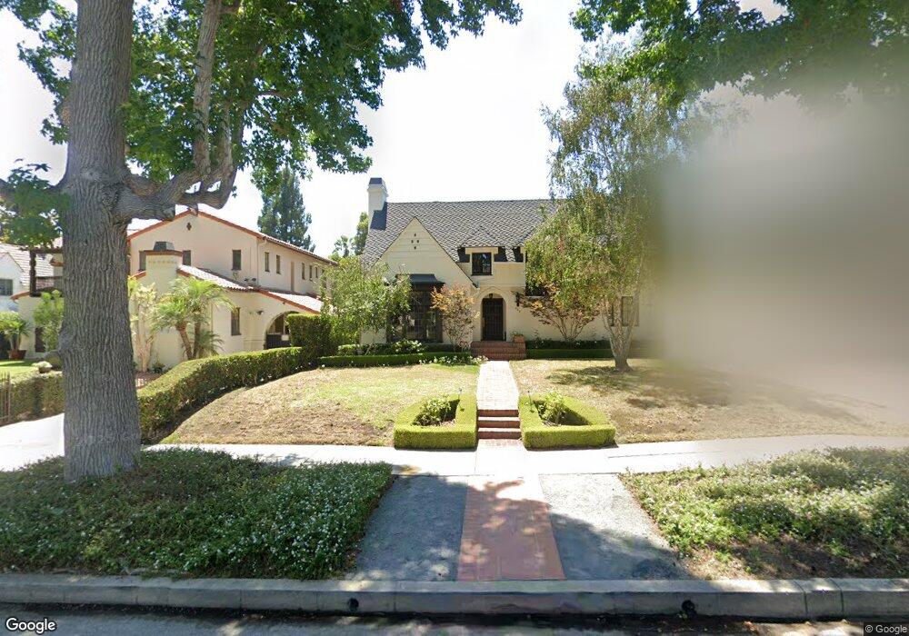
429 Loring Ave Los Angeles, CA 90024
Westwood NeighborhoodEstimated Value: $5,967,000 - $6,111,000
4
Beds
4
Baths
3,618
Sq Ft
$1,666/Sq Ft
Est. Value
About This Home
This home is located at 429 Loring Ave, Los Angeles, CA 90024 and is currently estimated at $6,028,238, approximately $1,666 per square foot. 429 Loring Ave is a home located in Los Angeles County with nearby schools including Warner Avenue Elementary, Ralph Waldo Emerson Community Charter Middle School, and University High School Charter.
Ownership History
Date
Name
Owned For
Owner Type
Purchase Details
Closed on
Feb 1, 2013
Sold by
Evangelatos Dennis and Evangelatos Kim
Bought by
Evangelatos Dennis and Evangelatos Kimberly Hodgert
Current Estimated Value
Purchase Details
Closed on
Jul 18, 2005
Sold by
Deutsch Dan and Deutsch Kathy
Bought by
Evangelatos Dennis
Home Financials for this Owner
Home Financials are based on the most recent Mortgage that was taken out on this home.
Original Mortgage
$1,400,000
Outstanding Balance
$717,079
Interest Rate
5.37%
Mortgage Type
Purchase Money Mortgage
Estimated Equity
$5,311,159
Create a Home Valuation Report for This Property
The Home Valuation Report is an in-depth analysis detailing your home's value as well as a comparison with similar homes in the area
Home Values in the Area
Average Home Value in this Area
Purchase History
| Date | Buyer | Sale Price | Title Company |
|---|---|---|---|
| Evangelatos Dennis | -- | None Available | |
| Evangelatos Dennis | $2,925,000 | California Title Company |
Source: Public Records
Mortgage History
| Date | Status | Borrower | Loan Amount |
|---|---|---|---|
| Open | Evangelatos Dennis | $1,400,000 |
Source: Public Records
Tax History Compared to Growth
Tax History
| Year | Tax Paid | Tax Assessment Tax Assessment Total Assessment is a certain percentage of the fair market value that is determined by local assessors to be the total taxable value of land and additions on the property. | Land | Improvement |
|---|---|---|---|---|
| 2025 | $49,474 | $4,158,600 | $2,428,963 | $1,729,637 |
| 2024 | $49,474 | $4,077,060 | $2,381,337 | $1,695,723 |
| 2023 | $48,507 | $3,997,119 | $2,334,645 | $1,662,474 |
| 2022 | $46,238 | $3,918,745 | $2,288,868 | $1,629,877 |
| 2021 | $45,675 | $3,841,908 | $2,243,989 | $1,597,919 |
| 2019 | $44,296 | $3,727,957 | $2,177,432 | $1,550,525 |
| 2018 | $44,131 | $3,654,861 | $2,134,738 | $1,520,123 |
| 2016 | $42,216 | $3,512,941 | $2,051,845 | $1,461,096 |
| 2015 | $41,592 | $3,460,174 | $2,021,025 | $1,439,149 |
| 2014 | $41,702 | $3,392,395 | $1,981,436 | $1,410,959 |
Source: Public Records
Map
Nearby Homes
- 453 Dalehurst Ave
- 365 Comstock Ave
- 365 Norcroft Ave
- 547 Loring Ave
- 601 Woodruff Ave
- 570 S Beverly Glen Blvd
- 10444 Charing Cross Rd
- 10386 Strathmore Dr
- 570 S Mapleton Dr
- 740 Warner Ave
- 10301 Strathmore Dr
- 200 S Mapleton Dr
- 850 Birchwood Dr
- 101 Bel Air Rd
- 820 Glenmont Ave
- 107 Delfern Dr
- 850 Thayer Ave
- 10452 Lindbrook Dr
- 10375 Wilshire Blvd Unit 2F
- 10375 Wilshire Blvd Unit 8F
- 423 Loring Ave
- 415 Loring Ave
- 441 Loring Ave
- 436 Dalehurst Ave
- 442 Dalehurst Ave
- 430 Dalehurst Ave
- 447 Loring Ave
- 448 Dalehurst Ave
- 422 Lomond Ave
- 411 Loring Ave
- 420 Loring Ave
- 428 Loring Ave
- 414 Lomond Ave
- 436 Loring Ave
- 454 Dalehurst Ave
- 453 Loring Ave
- 414 Loring Ave
- 401 Loring Ave
- 460 Dalehurst Ave
- 452 Loring Ave