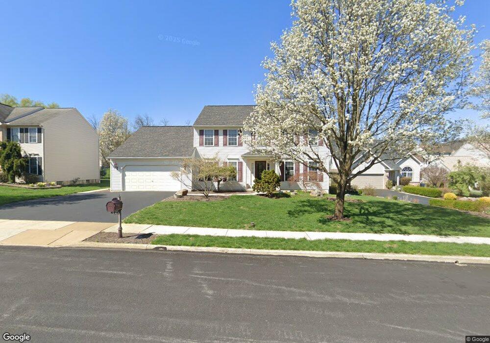
431 Wingspread Ct Reading, PA 19606
Estimated Value: $483,000 - $576,000
4
Beds
4
Baths
2,864
Sq Ft
$179/Sq Ft
Est. Value
About This Home
This home is located at 431 Wingspread Ct, Reading, PA 19606 and is currently estimated at $512,361, approximately $178 per square foot. 431 Wingspread Ct is a home located in Berks County with nearby schools including Owatin Creek Elementary School, Exeter Township Junior High School, and Exeter Township Senior High School.
Ownership History
Date
Name
Owned For
Owner Type
Purchase Details
Closed on
Jan 16, 2001
Sold by
Berks Construction Co Inc
Bought by
Galitz Mitchell R and Galitz Karen R
Current Estimated Value
Home Financials for this Owner
Home Financials are based on the most recent Mortgage that was taken out on this home.
Original Mortgage
$189,000
Outstanding Balance
$69,633
Interest Rate
7.52%
Estimated Equity
$442,728
Create a Home Valuation Report for This Property
The Home Valuation Report is an in-depth analysis detailing your home's value as well as a comparison with similar homes in the area
Home Values in the Area
Average Home Value in this Area
Purchase History
| Date | Buyer | Sale Price | Title Company |
|---|---|---|---|
| Galitz Mitchell R | $199,436 | -- |
Source: Public Records
Mortgage History
| Date | Status | Borrower | Loan Amount |
|---|---|---|---|
| Open | Galitz Mitchell R | $189,000 |
Source: Public Records
Tax History
| Year | Tax Paid | Tax Assessment Tax Assessment Total Assessment is a certain percentage of the fair market value that is determined by local assessors to be the total taxable value of land and additions on the property. | Land | Improvement |
|---|---|---|---|---|
| 2025 | $2,738 | $184,900 | $39,600 | $145,300 |
| 2024 | $8,781 | $184,900 | $39,600 | $145,300 |
| 2023 | $8,494 | $184,900 | $39,600 | $145,300 |
| 2022 | $8,399 | $184,900 | $39,600 | $145,300 |
| 2021 | $8,271 | $184,900 | $39,600 | $145,300 |
| 2020 | $8,180 | $184,900 | $39,600 | $145,300 |
| 2019 | $8,089 | $184,900 | $39,600 | $145,300 |
| 2018 | $8,065 | $184,900 | $39,600 | $145,300 |
| 2017 | $7,949 | $184,900 | $39,600 | $145,300 |
| 2016 | $1,972 | $184,900 | $39,600 | $145,300 |
| 2015 | $1,972 | $184,900 | $39,600 | $145,300 |
| 2014 | $1,903 | $184,900 | $39,600 | $145,300 |
Source: Public Records
Map
Nearby Homes
- 390 Wingspread Dr
- 36 Pickwick Place
- 200 Walton Ct
- 29 Ladderback Ln
- 17 Hawley Ct
- 71 Winchester Ct
- 11 Valley Dr
- 1 Fairway Dr
- 2 Fairway Dr
- 99 Constitution Ave
- 700 Fabers Rd
- 39 Fox Glove Ln
- 132 Rugby Rd
- 840 Shelbourne Rd
- 124 Fairmount Ave
- 1200 Schoffers Rd
- 0 S Fairway Dr Unit PABK2068302
- 4910 Dunham Dr
- 105 Fairmount Ave
- 140 Heister Rd
- 441 Wingspread Ct
- 421 Wingspread Ct
- 425 Pennsylvania Ave
- 419 Pennsylvania Ave
- 411 Wingspread Ct
- 451 Wingspread Ct
- 431 Pennsylvania Ave
- 430 Wingspread Ct
- 413 Pennsylvania Ave
- 440 Wingspread Ct
- 437 Pennsylvania Ave
- 461 Wingspread Ct
- 3 Hideaway Ct
- 450 Wingspread Ct
- 184 Valley Dr
- 443 Pennsylvania Ave
- 443 Pennsylvania Ave
- 188 Valley Dr
- 11 Boxwood Ct
- 418 Pennsylvania Ave
Your Personal Tour Guide
Ask me questions while you tour the home.