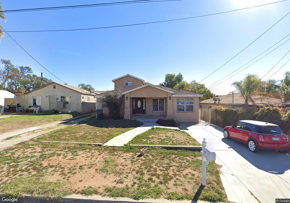
4310 Byrne Rd Riverside, CA 92509
Glen Avon NeighborhoodEstimated Value: $687,000 - $747,952
6
Beds
3
Baths
2,731
Sq Ft
$267/Sq Ft
Est. Value
About This Home
This home is located at 4310 Byrne Rd, Riverside, CA 92509 and is currently estimated at $729,238, approximately $267 per square foot. 4310 Byrne Rd is a home located in Riverside County with nearby schools including Glen Avon Elementary School, Jurupa Middle School, and Patriot High School.
Ownership History
Date
Name
Owned For
Owner Type
Purchase Details
Closed on
Apr 25, 2025
Sold by
Contreras Lilian M
Bought by
Lilian M Contreras Revocable Trust and Contreras
Current Estimated Value
Purchase Details
Closed on
May 9, 2005
Sold by
Contreras Guillermo
Bought by
Contreras Guillermo and Contreras Lilian M
Home Financials for this Owner
Home Financials are based on the most recent Mortgage that was taken out on this home.
Original Mortgage
$237,250
Interest Rate
6.69%
Mortgage Type
Stand Alone Refi Refinance Of Original Loan
Purchase Details
Closed on
Feb 3, 2004
Sold by
Brazee Giles T and Brazee Sandra J
Bought by
Contreras Guillermo
Home Financials for this Owner
Home Financials are based on the most recent Mortgage that was taken out on this home.
Original Mortgage
$144,000
Interest Rate
5.62%
Mortgage Type
Purchase Money Mortgage
Create a Home Valuation Report for This Property
The Home Valuation Report is an in-depth analysis detailing your home's value as well as a comparison with similar homes in the area
Home Values in the Area
Average Home Value in this Area
Purchase History
| Date | Buyer | Sale Price | Title Company |
|---|---|---|---|
| Lilian M Contreras Revocable Trust | -- | None Listed On Document | |
| Contreras Guillermo | -- | Commonwealth Land Title Co | |
| Contreras Guillermo | $180,000 | Commonwealth Land Title Co |
Source: Public Records
Mortgage History
| Date | Status | Borrower | Loan Amount |
|---|---|---|---|
| Previous Owner | Contreras Guillermo | $237,250 | |
| Previous Owner | Contreras Guillermo | $144,000 |
Source: Public Records
Tax History Compared to Growth
Tax History
| Year | Tax Paid | Tax Assessment Tax Assessment Total Assessment is a certain percentage of the fair market value that is determined by local assessors to be the total taxable value of land and additions on the property. | Land | Improvement |
|---|---|---|---|---|
| 2025 | $4,812 | $419,052 | $71,075 | $347,977 |
| 2023 | $4,812 | $402,781 | $68,316 | $334,465 |
| 2022 | $4,390 | $394,884 | $66,977 | $327,907 |
| 2021 | $4,360 | $387,142 | $65,664 | $321,478 |
| 2020 | $4,321 | $383,173 | $64,991 | $318,182 |
| 2019 | $4,236 | $375,661 | $63,717 | $311,944 |
| 2018 | $4,099 | $368,296 | $62,469 | $305,827 |
| 2017 | $4,058 | $361,076 | $61,245 | $299,831 |
| 2016 | $4,003 | $353,997 | $60,045 | $293,952 |
| 2015 | $3,949 | $348,682 | $59,144 | $289,538 |
| 2014 | $3,103 | $288,000 | $49,000 | $239,000 |
Source: Public Records
Map
Nearby Homes
- 7411 Eddy Ave
- 7081 Valley Way
- 7035 Jurupa Rd
- 7319 Rocky Point Rd
- 7627 Mission Blvd
- 7635 Mission Blvd
- 7340 Garnet Ridge Rd
- 4615 Fairbanks Ave
- 0 Jewel St
- 6916 36th St
- 6661 Raven Cir
- 4688 Plaza Ln
- 4290 Hernandez St
- 4473 Jericho St
- 7858 Sherry Ln
- 4092 Sandpiper Dr
- 4852 Mount Abbott St
- 3483 Skylane Dr
- 6452 Mission Blvd
- 3700 3700 Quartz Canyon Unit 41