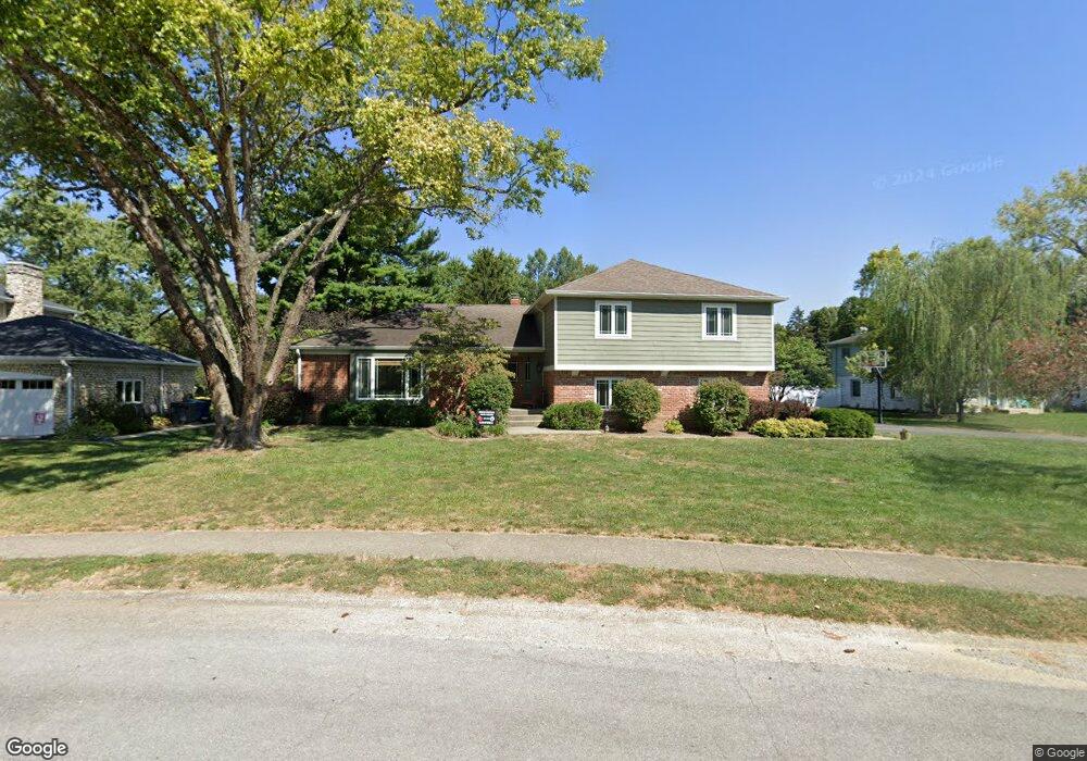
4320 Cranbrook Dr Indianapolis, IN 46250
Allisonville NeighborhoodEstimated Value: $485,423 - $550,000
4
Beds
3
Baths
3,128
Sq Ft
$167/Sq Ft
Est. Value
About This Home
This home is located at 4320 Cranbrook Dr, Indianapolis, IN 46250 and is currently estimated at $521,106, approximately $166 per square foot. 4320 Cranbrook Dr is a home located in Marion County with nearby schools including Allisonville Elementary School, Eastwood Middle School, and North Central High School.
Ownership History
Date
Name
Owned For
Owner Type
Purchase Details
Closed on
Aug 31, 2007
Sold by
Cumming James and Cumming Megan
Bought by
Campbell Valerie L and Campbell Matthew J
Current Estimated Value
Home Financials for this Owner
Home Financials are based on the most recent Mortgage that was taken out on this home.
Original Mortgage
$200,000
Outstanding Balance
$127,596
Interest Rate
6.72%
Mortgage Type
New Conventional
Estimated Equity
$393,510
Create a Home Valuation Report for This Property
The Home Valuation Report is an in-depth analysis detailing your home's value as well as a comparison with similar homes in the area
Home Values in the Area
Average Home Value in this Area
Purchase History
| Date | Buyer | Sale Price | Title Company |
|---|---|---|---|
| Campbell Valerie L | -- | None Available |
Source: Public Records
Mortgage History
| Date | Status | Borrower | Loan Amount |
|---|---|---|---|
| Open | Campbell Valerie L | $200,000 |
Source: Public Records
Tax History
| Year | Tax Paid | Tax Assessment Tax Assessment Total Assessment is a certain percentage of the fair market value that is determined by local assessors to be the total taxable value of land and additions on the property. | Land | Improvement |
|---|---|---|---|---|
| 2024 | $4,675 | $353,700 | $70,600 | $283,100 |
| 2023 | $4,675 | $352,000 | $70,600 | $281,400 |
| 2022 | $4,896 | $369,200 | $70,600 | $298,600 |
| 2021 | $4,090 | $296,900 | $43,400 | $253,500 |
| 2020 | $3,984 | $306,100 | $43,400 | $262,700 |
| 2019 | $3,506 | $287,400 | $43,400 | $244,000 |
| 2018 | $3,361 | $282,200 | $43,400 | $238,800 |
| 2017 | $3,110 | $264,400 | $43,400 | $221,000 |
| 2016 | $2,720 | $247,500 | $43,400 | $204,100 |
| 2014 | $2,428 | $238,000 | $43,400 | $194,600 |
| 2013 | $2,666 | $246,600 | $43,400 | $203,200 |
Source: Public Records
Map
Nearby Homes
- 4730 E 71st St
- 7102 Dean Rd
- 3850 Glenview Dr
- 4820 E 70th St
- 4904 E 70th St
- 7620 Dean Rd
- 7303 Merriam Rd
- 7710 Cree Trail
- 7254 Merriam Rd
- 3737 E 71st St
- 7643 Dean Rd
- 7433 Longleat Rd
- 4996 E 65th St
- 3932 Wyandotte Trail
- 3518 Admiralty Ln
- 7811 Providence Cir
- 7748 N Sherman Dr
- 6972 Steinmeier Dr W
- 7504 Harbour Isle
- 7580 Harbour Isle
- 4310 Cranbrook Dr
- 7250 Chelsea Ct
- 7229 Cranbrook Ct
- 4329 Briarwood Dr
- 4319 Briarwood Dr
- 4240 Cranbrook Dr
- 7249 Chelsea Ct
- 4330 Cranbrook Dr
- 4339 Briarwood Dr
- 4309 Briarwood Dr
- 4325 Cranbrook Dr
- 4500 Cranbrook Dr
- 4239 Briarwood Dr
- 7230 Cranbrook Ct
- 4407 Briarwood Dr
- 4230 Cranbrook Dr
- 4417 Briarwood Dr
- 4410 Cranbrook Dr
- 7225 Cranbrook Ct
- 4427 Briarwood Dr
Your Personal Tour Guide
Ask me questions while you tour the home.