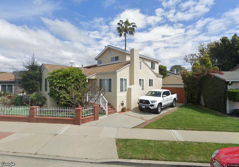
4328 Mcconnell Blvd Los Angeles, CA 90066
Del Rey NeighborhoodEstimated Value: $1,496,475 - $1,923,000
4
Beds
2
Baths
1,592
Sq Ft
$1,047/Sq Ft
Est. Value
About This Home
This home is located at 4328 Mcconnell Blvd, Los Angeles, CA 90066 and is currently estimated at $1,667,119, approximately $1,047 per square foot. 4328 Mcconnell Blvd is a home located in Los Angeles County with nearby schools including La Ballona Elementary School, Culver City Middle School, and Culver City High School.
Ownership History
Date
Name
Owned For
Owner Type
Purchase Details
Closed on
Jul 30, 2024
Sold by
Mair Scott C and Mair Margarita T
Bought by
Mair Family Trust and Mair
Current Estimated Value
Purchase Details
Closed on
Jan 24, 1995
Sold by
Hewitt Lawrence R
Bought by
Mair Scott C
Home Financials for this Owner
Home Financials are based on the most recent Mortgage that was taken out on this home.
Original Mortgage
$120,000
Interest Rate
9.2%
Create a Home Valuation Report for This Property
The Home Valuation Report is an in-depth analysis detailing your home's value as well as a comparison with similar homes in the area
Home Values in the Area
Average Home Value in this Area
Purchase History
| Date | Buyer | Sale Price | Title Company |
|---|---|---|---|
| Mair Family Trust | -- | None Listed On Document | |
| Mair Scott C | $150,000 | First American Title Co |
Source: Public Records
Mortgage History
| Date | Status | Borrower | Loan Amount |
|---|---|---|---|
| Previous Owner | Mair Scott C | $120,000 |
Source: Public Records
Tax History Compared to Growth
Tax History
| Year | Tax Paid | Tax Assessment Tax Assessment Total Assessment is a certain percentage of the fair market value that is determined by local assessors to be the total taxable value of land and additions on the property. | Land | Improvement |
|---|---|---|---|---|
| 2025 | $5,385 | $337,980 | $201,553 | $136,427 |
| 2024 | $5,385 | $331,353 | $197,601 | $133,752 |
| 2023 | $5,186 | $324,857 | $193,727 | $131,130 |
| 2022 | $4,944 | $318,488 | $189,929 | $128,559 |
| 2021 | $4,833 | $312,244 | $186,205 | $126,039 |
| 2019 | $4,697 | $302,984 | $180,683 | $122,301 |
| 2018 | $4,447 | $297,044 | $177,141 | $119,903 |
| 2016 | $4,070 | $285,511 | $170,263 | $115,248 |
| 2015 | $4,020 | $281,223 | $167,706 | $113,517 |
| 2014 | $4,064 | $275,715 | $164,421 | $111,294 |
Source: Public Records
Map
Nearby Homes
- 4373 Mcconnell Blvd
- 4260 Mcconnell Blvd
- 4250 Mcconnell Blvd
- 12836 Gilmore Ave
- 4336 Alla Rd
- 4410 Stewart Ave
- 12534 Gilmore Ave
- 12930 Gilmore Ave
- 4220 Kenyon Ave
- 12520 Gilmore Ave
- 12939 Greene Ave
- 12870 Walsh Ave
- 13065 Mindanao Way Unit 3
- 12837 Bonaparte Ave
- 12616 Bonaparte Ave
- 4316 Westlawn Ave
- 13044 Mindanao Way Unit 2
- 12926 Bonaparte Ave
- 12537 Rubens Ave
- 12850 Admiral Ave
- 4318 Mcconnell Blvd
- 4332 Mcconnell Blvd
- 4316 Mildred Ave
- 4341 Neosho Ave
- 4337 Neosho Ave
- 4345 Neosho Ave
- 4314 Mildred Ave
- 4329 Mcconnell Blvd
- 4333 Mcconnell Blvd
- 4333 Neosho Ave
- 4349 Neosho Ave
- 4325 Mcconnell Blvd
- 4339 Mcconnell Blvd
- 4310 Mildred Ave
- 4329 Neosho Ave
- 4321 Mcconnell Blvd
- 4343 Mcconnell Blvd
- 4353 Neosho Ave
- 4317 Mcconnell Blvd
- 4325 Neosho Ave