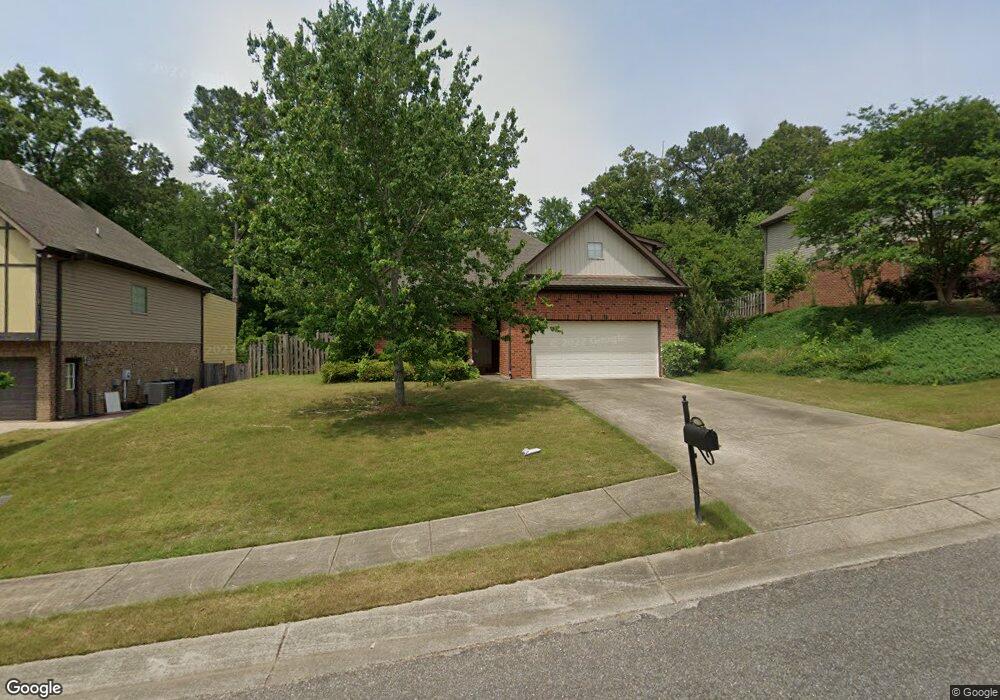
433 Ramsgate Dr Unit 381 Alabaster, AL 35114
Estimated Value: $323,107 - $340,000
4
Beds
2
Baths
1,936
Sq Ft
$172/Sq Ft
Est. Value
About This Home
This home is located at 433 Ramsgate Dr Unit 381, Alabaster, AL 35114 and is currently estimated at $333,027, approximately $172 per square foot. 433 Ramsgate Dr Unit 381 is a home located in Shelby County with nearby schools including Thompson Intermediate School, Thompson Middle School, and Thompson High School.
Ownership History
Date
Name
Owned For
Owner Type
Purchase Details
Closed on
Dec 18, 2021
Sold by
Sparks Perami
Bought by
Sparks Perami and Sparks Yolanda T
Current Estimated Value
Home Financials for this Owner
Home Financials are based on the most recent Mortgage that was taken out on this home.
Original Mortgage
$171,000
Outstanding Balance
$133,697
Interest Rate
2.34%
Mortgage Type
New Conventional
Estimated Equity
$199,330
Purchase Details
Closed on
May 5, 2016
Sold by
Burns Rebecca S and Burns Billy R
Bought by
Sparks Perami
Home Financials for this Owner
Home Financials are based on the most recent Mortgage that was taken out on this home.
Original Mortgage
$179,685
Interest Rate
3.37%
Mortgage Type
FHA
Purchase Details
Closed on
Sep 28, 2009
Sold by
Regions Bank
Bought by
Burns Billy R and Burns Rebecca S
Home Financials for this Owner
Home Financials are based on the most recent Mortgage that was taken out on this home.
Original Mortgage
$119,920
Interest Rate
5.03%
Mortgage Type
New Conventional
Create a Home Valuation Report for This Property
The Home Valuation Report is an in-depth analysis detailing your home's value as well as a comparison with similar homes in the area
Home Values in the Area
Average Home Value in this Area
Purchase History
| Date | Buyer | Sale Price | Title Company |
|---|---|---|---|
| Sparks Perami | -- | None Listed On Document | |
| Sparks Perami | -- | Orange Coast Lender Services | |
| Sparks Perami | $183,000 | None Available | |
| Burns Billy R | $149,900 | None Available |
Source: Public Records
Mortgage History
| Date | Status | Borrower | Loan Amount |
|---|---|---|---|
| Open | Sparks Perami | $171,000 | |
| Closed | Sparks Perami | $171,000 | |
| Previous Owner | Sparks Perami | $179,685 | |
| Previous Owner | Burns Billy R | $119,920 |
Source: Public Records
Tax History
| Year | Tax Paid | Tax Assessment Tax Assessment Total Assessment is a certain percentage of the fair market value that is determined by local assessors to be the total taxable value of land and additions on the property. | Land | Improvement |
|---|---|---|---|---|
| 2024 | $1,570 | $29,080 | $0 | $0 |
| 2023 | $1,433 | $27,300 | $0 | $0 |
| 2022 | $1,327 | $25,340 | $0 | $0 |
| 2021 | $1,199 | $22,960 | $0 | $0 |
| 2020 | $1,150 | $22,060 | $0 | $0 |
| 2019 | $1,133 | $21,740 | $0 | $0 |
| 2017 | $1,034 | $19,900 | $0 | $0 |
| 2015 | $2,073 | $38,380 | $0 | $0 |
| 2014 | $2,026 | $37,520 | $0 | $0 |
Source: Public Records
Map
Nearby Homes
- 120 Mayfair Park
- 135 Kingsley Rd
- 109 Kingsley Cir
- 124 Kingsley Rd
- 306 Mayfair Cir
- 208 Queens Gate
- 236 Queens Gate
- 501 Ramsgate Dr
- 312 Cornwall Dr
- 537 Ramsgate Dr
- 2001 1st Ave W
- 544 Ramsgate Dr
- 105 Abington Cir
- 305 Cedar Grove Ct
- 174 Cedar Grove Pkwy
- 309 Cedar Grove Ct
- 545 Ramsgate Dr
- 549 Ramsgate Dr
- 413 Cornwall Dr
- 132 Victoria Station
- 433 Ramsgate Dr
- 429 Ramsgate Dr
- 429 Ramsgate Dr Unit 380
- 437 Ramsgate Dr
- 437 Ramsgate Dr Unit 382
- 10 Ramsgate Dr
- 12 Ramsgate Dr
- 18 Ramsgate Dr
- 45 Ramsgate Dr
- 42 Ramsgate Dr
- 38 Ramsgate Dr
- 35 Ramsgate Dr
- 425 Ramsgate Dr
- 425 Ramsgate Dr
- 432 Ramsgate Dr
- 441 Ramsgate Dr Unit 383
- 441 Ramsgate Dr
- 428 Ramsgate Dr
- 428 Ramsgate Dr Unit 369
- 436 Ramsgate Dr
Your Personal Tour Guide
Ask me questions while you tour the home.