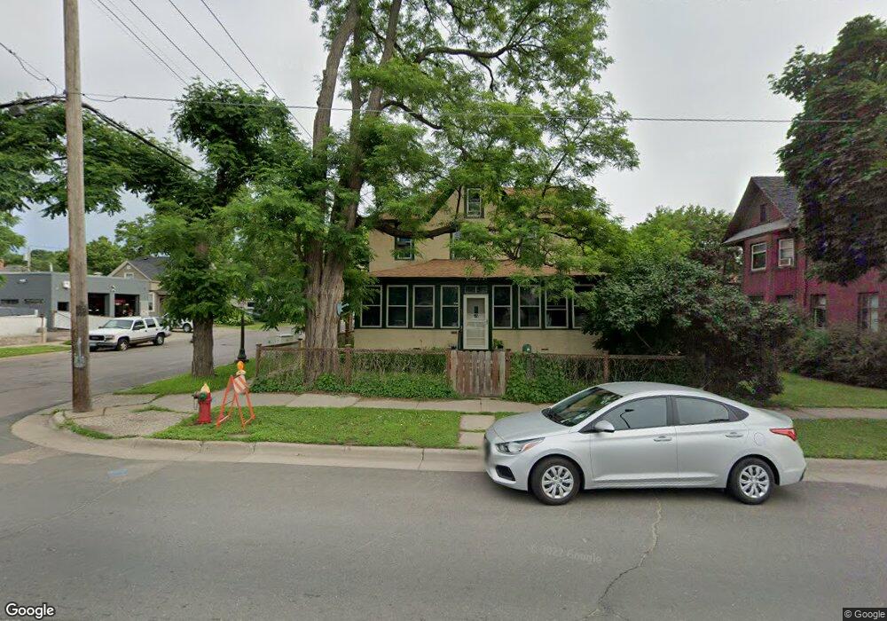
439 Saint Clair Ave Saint Paul, MN 55102
West Seventh NeighborhoodEstimated Value: $255,055 - $367,000
4
Beds
1
Bath
1,500
Sq Ft
$201/Sq Ft
Est. Value
About This Home
This home is located at 439 Saint Clair Ave, Saint Paul, MN 55102 and is currently estimated at $301,014, approximately $200 per square foot. 439 Saint Clair Ave is a home located in Ramsey County with nearby schools including Randolph Heights Elementary School, Hidden River Middle School, and Central Senior High School.
Ownership History
Date
Name
Owned For
Owner Type
Purchase Details
Closed on
Mar 21, 2022
Sold by
Gleason Daniel J and Gleason Melissa A
Bought by
Gleason Samuel F and Gleason John
Current Estimated Value
Purchase Details
Closed on
Aug 19, 1996
Sold by
Sparkman John E
Bought by
Fearing Patrick and Fearing Darlene L N
Create a Home Valuation Report for This Property
The Home Valuation Report is an in-depth analysis detailing your home's value as well as a comparison with similar homes in the area
Home Values in the Area
Average Home Value in this Area
Purchase History
| Date | Buyer | Sale Price | Title Company |
|---|---|---|---|
| Gleason Samuel F | $425,000 | None Listed On Document | |
| Fearing Patrick | $41,900 | -- |
Source: Public Records
Tax History
| Year | Tax Paid | Tax Assessment Tax Assessment Total Assessment is a certain percentage of the fair market value that is determined by local assessors to be the total taxable value of land and additions on the property. | Land | Improvement |
|---|---|---|---|---|
| 2025 | $3,356 | $237,400 | $36,000 | $201,400 |
| 2023 | $3,356 | $226,800 | $36,000 | $190,800 |
| 2022 | $2,968 | $202,800 | $36,000 | $166,800 |
| 2021 | $2,974 | $197,500 | $36,000 | $161,500 |
| 2020 | $3,090 | $204,200 | $23,600 | $180,600 |
| 2019 | $2,868 | $198,500 | $23,600 | $174,900 |
| 2018 | $2,676 | $183,900 | $23,600 | $160,300 |
| 2017 | $2,200 | $178,300 | $23,600 | $154,700 |
| 2016 | $2,172 | $0 | $0 | $0 |
| 2015 | $2,228 | $150,400 | $16,000 | $134,400 |
| 2014 | $2,152 | $0 | $0 | $0 |
Source: Public Records
Map
Nearby Homes
- 253 Richmond St
- 275 Western Ave S
- 254 Western Ave S
- 240 1/2 Western Ave S Unit G2
- 282 Erie St
- 294 Banfil St
- 89 Douglas St
- 383 Grand Ave Unit 9
- 309 W Harrison Ave
- 385 Toronto St
- 577 Lincoln Ave
- 456 Summit Ave Unit 203
- 659 Jefferson Ave
- 345 Grand Ave
- 506 Summit Ave
- 345 Ramsey St Unit 345B
- 614 Grand Ave Unit C
- 349 Ramsey St Unit 349A
- 199 McBoal St Unit 1
- 582 Summit Ave
- 431 Saint Clair Ave
- 427 Saint Clair Ave
- 447 Saint Clair Ave
- 432 Michigan St
- 452 452 St Clair-Avenue-
- 225 Richmond St
- 430 Michigan St
- 247 Richmond St
- 426 Michigan St
- 453 Saint Clair Ave
- 217 Richmond St
- 452 Saint Clair Ave
- 444 Michigan St
- 422 Michigan St
- 249 Richmond St
- 452 Michigan St
- 458 Saint Clair Ave
- 454 Michigan St
- 466 466 St Clair-Avenue-
- 469 Saint Clair Ave
Your Personal Tour Guide
Ask me questions while you tour the home.