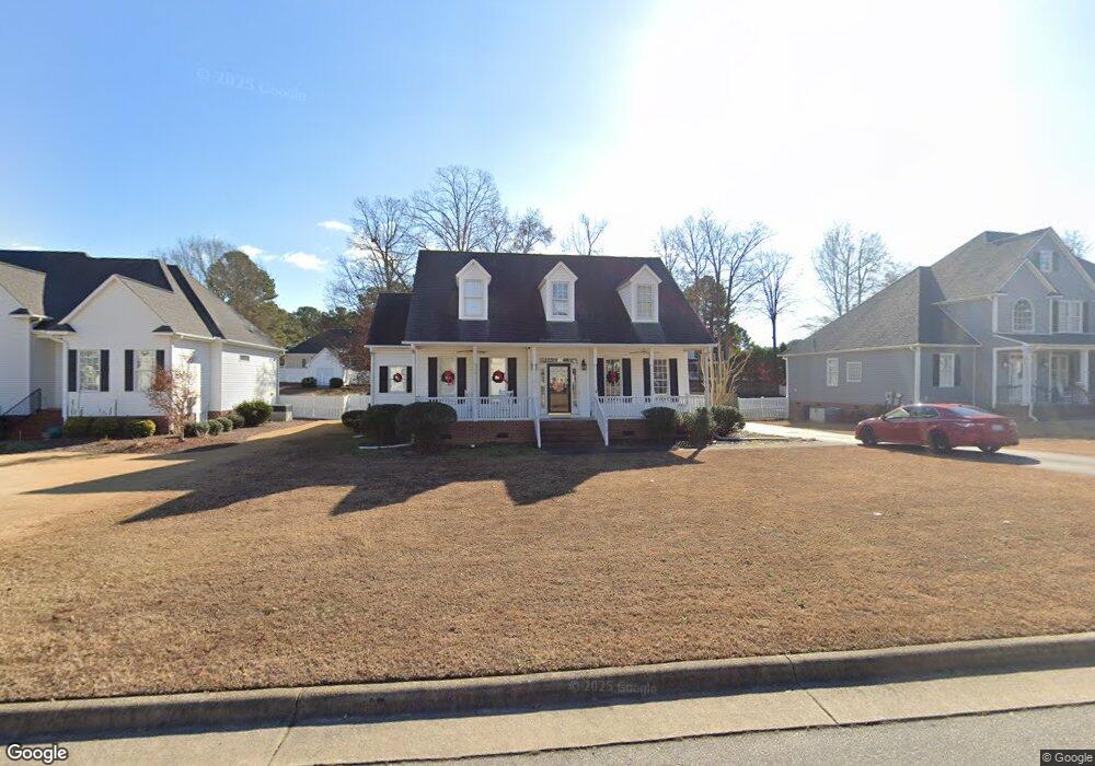
4413 Davis Farms Dr N Wilson, NC 27896
Estimated Value: $371,086 - $442,000
3
Beds
3
Baths
2,778
Sq Ft
$143/Sq Ft
Est. Value
About This Home
This home is located at 4413 Davis Farms Dr N, Wilson, NC 27896 and is currently estimated at $397,022, approximately $142 per square foot. 4413 Davis Farms Dr N is a home located in Wilson County with nearby schools including New Hope Elementary School, Elm City Middle School, and Fike High School.
Ownership History
Date
Name
Owned For
Owner Type
Purchase Details
Closed on
Dec 5, 2019
Sold by
Gay Larry Scott
Bought by
Gay Sarah Ellis
Current Estimated Value
Purchase Details
Closed on
Mar 15, 2018
Sold by
Bass Samuel S and Bass Marty B
Bought by
Gay Larry Scott and Gay Sarah Ellis
Home Financials for this Owner
Home Financials are based on the most recent Mortgage that was taken out on this home.
Original Mortgage
$115,000
Outstanding Balance
$98,170
Interest Rate
4.22%
Mortgage Type
Unknown
Estimated Equity
$298,853
Create a Home Valuation Report for This Property
The Home Valuation Report is an in-depth analysis detailing your home's value as well as a comparison with similar homes in the area
Home Values in the Area
Average Home Value in this Area
Purchase History
| Date | Buyer | Sale Price | Title Company |
|---|---|---|---|
| Gay Sarah Ellis | -- | None Available | |
| Gay Larry Scott | $215,000 | None Available |
Source: Public Records
Mortgage History
| Date | Status | Borrower | Loan Amount |
|---|---|---|---|
| Open | Gay Larry Scott | $115,000 |
Source: Public Records
Tax History Compared to Growth
Tax History
| Year | Tax Paid | Tax Assessment Tax Assessment Total Assessment is a certain percentage of the fair market value that is determined by local assessors to be the total taxable value of land and additions on the property. | Land | Improvement |
|---|---|---|---|---|
| 2025 | $3,959 | $353,443 | $50,000 | $303,443 |
| 2024 | $3,959 | $353,443 | $50,000 | $303,443 |
| 2023 | $3,188 | $244,258 | $40,000 | $204,258 |
| 2022 | $3,188 | $244,258 | $40,000 | $204,258 |
| 2021 | $0 | $244,258 | $40,000 | $204,258 |
| 2020 | $3,188 | $244,258 | $40,000 | $204,258 |
| 2019 | $3,267 | $244,258 | $40,000 | $204,258 |
| 2018 | $3,188 | $244,258 | $40,000 | $204,258 |
| 2017 | $3,139 | $244,258 | $40,000 | $204,258 |
| 2016 | $3,139 | $244,258 | $40,000 | $204,258 |
| 2014 | $3,178 | $250,288 | $40,000 | $210,288 |
Source: Public Records
Map
Nearby Homes
- 4629 Dewfield Dr N
- 4400 Davis Farms Dr N
- 4200 Dewfield Dr N
- 4710 Burning Tree Ln N
- 4502 Saint Andrews Dr N
- 4500 Saint Andrews Dr N
- 4800 Burning Tree Ln N
- 4511 Bobwhite Trail N
- 4610 Pinehurst Dr N
- 4804 Burning Tree Ln N
- 4702 Tamarisk Ln
- 4702 Tamerisk Ln N
- 4506 Saint Andrews Dr N
- 4805 Milliken Close N
- 4702 Nash St N
- 4707 Saint Andrews Dr N Unit B
- 4707 Saint Andrews Dr N Unit B
- 3203 Tilghman Rd N
- 3902 Redbay Ln
- 4121 Little John Dr N
- 4415 Davis Farms Dr N
- 4415 N Davis Farms Dr
- 4411 Davis Farms Dr N
- 4417 Davis Farms Dr N
- 4626 Dewfield Dr N
- 4630 Dewfield Dr N
- 4414 Davis Farms Dr N
- 4409 Davis Farms Dr N
- 4412 Davis Farms Dr N
- 4416 Davis Farms Dr N
- 4632 Dewfield Dr N
- 4410 Davis Farms Dr N
- 4418 Davis Farms Dr N
- 4624 Dewfield Dr N
- 4405 Davis Farms
- 4408 Davis Farms Dr N
- 4634 Dewfield Dr N
- 4420 Davis Farms Dr N
- 4627 Dewfield Dr N
- 4625 Dewfield Dr N