Estimated Value: $423,023 - $482,000
3
Beds
2
Baths
1,188
Sq Ft
$384/Sq Ft
Est. Value
About This Home
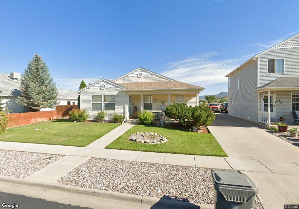
This home is located at 442 Columbine Dr, Rifle, CO 81650 and is currently estimated at $456,006, approximately $383 per square foot. 442 Columbine Dr is a home located in Garfield County with nearby schools including Wamsley Elementary School, Rifle Middle School, and Rifle High School.
Ownership History
Date
Name
Owned For
Owner Type
Purchase Details
Closed on
Jan 25, 2006
Sold by
Sandquist John M
Bought by
Sandquist John M and Sandquist Melissa
Current Estimated Value
Home Financials for this Owner
Home Financials are based on the most recent Mortgage that was taken out on this home.
Original Mortgage
$178,500
Outstanding Balance
$114,654
Interest Rate
8.7%
Mortgage Type
New Conventional
Estimated Equity
$341,352
Purchase Details
Closed on
Jul 21, 2000
Sold by
Deerfield Park Llc
Bought by
Sandquist John M
Create a Home Valuation Report for This Property
The Home Valuation Report is an in-depth analysis detailing your home's value as well as a comparison with similar homes in the area
Home Values in the Area
Average Home Value in this Area
Purchase History
| Date | Buyer | Sale Price | Title Company |
|---|---|---|---|
| Sandquist John M | -- | None Available | |
| Sandquist John M | $141,000 | -- |
Source: Public Records
Mortgage History
| Date | Status | Borrower | Loan Amount |
|---|---|---|---|
| Open | Sandquist John M | $178,500 |
Source: Public Records
Tax History Compared to Growth
Tax History
| Year | Tax Paid | Tax Assessment Tax Assessment Total Assessment is a certain percentage of the fair market value that is determined by local assessors to be the total taxable value of land and additions on the property. | Land | Improvement |
|---|---|---|---|---|
| 2024 | $1,529 | $20,050 | $2,490 | $17,560 |
| 2023 | $1,529 | $20,050 | $2,490 | $17,560 |
| 2022 | $1,291 | $18,030 | $3,480 | $14,550 |
| 2021 | $1,483 | $18,550 | $3,580 | $14,970 |
| 2020 | $1,261 | $17,240 | $2,570 | $14,670 |
| 2019 | $1,193 | $17,240 | $2,570 | $14,670 |
| 2018 | $1,025 | $14,480 | $2,380 | $12,100 |
| 2017 | $926 | $14,480 | $2,380 | $12,100 |
| 2016 | $785 | $13,890 | $2,150 | $11,740 |
| 2015 | $725 | $13,890 | $2,150 | $11,740 |
| 2014 | -- | $9,910 | $1,550 | $8,360 |
Source: Public Records
Map
Nearby Homes
- 321 Columbine Dr
- Phase 2 Rifle Creek
- 148 W 26th St
- Phase 1B Tbd Creekside Dr
- 2659 Acacia Ave Unit 2C
- 2501 Meadow Cir Unit 1
- 211 W 28th Ct
- 3053 Coal Mine Ave
- 2203 Ute Ave
- 405 W 26th St
- 1103 E 18th St
- 2409 W 24th Place
- 1783 Anvil View Ave
- 1663 Walnut
- 1173 E 17th St
- 1607 Balsam Loop
- 1205 E 17th St
- 1279 E 17th St
- 2638 Shawnee Ct
- 200 W 20th St Unit A142
- 438 Columbine Dr
- 450 Columbine Dr
- 456 Columbine Dr
- 432 Columbine Dr
- 441 Columbine Dr
- 447 Columbine Dr
- 439 Columbine Dr
- 453 Columbine Dr
- 459 Columbine Dr
- 428 Columbine Dr
- 435 Columbine Dr
- 502 Columbine Dr
- 427 Columbine Dr
- 424 Columbine Dr
- 448 Evergreen Dr
- 0 Evergreen Dr Unit 640635
- 452 Evergreen Dr
- 506 Columbine Dr
- 440 Evergreen Dr
- 423 Columbine Dr