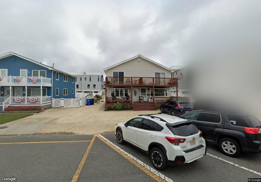
442 Engleside Ave Unit U1 Beach Haven, NJ 08008
Long Beach Island NeighborhoodEstimated Value: $732,000 - $1,086,000
3
Beds
2
Baths
1,152
Sq Ft
$788/Sq Ft
Est. Value
About This Home
This home is located at 442 Engleside Ave Unit U1, Beach Haven, NJ 08008 and is currently estimated at $908,095, approximately $788 per square foot. 442 Engleside Ave Unit U1 is a home located in Ocean County with nearby schools including Beach Haven School, Southern Regional Middle School, and Southern Regional High School.
Ownership History
Date
Name
Owned For
Owner Type
Purchase Details
Closed on
Jun 3, 2005
Sold by
Cucinotta Michael and Cucinotta Michele
Bought by
Suwak Daniel and Suwak Linda
Current Estimated Value
Home Financials for this Owner
Home Financials are based on the most recent Mortgage that was taken out on this home.
Original Mortgage
$359,650
Outstanding Balance
$188,121
Interest Rate
5.79%
Mortgage Type
Fannie Mae Freddie Mac
Estimated Equity
$719,974
Create a Home Valuation Report for This Property
The Home Valuation Report is an in-depth analysis detailing your home's value as well as a comparison with similar homes in the area
Home Values in the Area
Average Home Value in this Area
Purchase History
| Date | Buyer | Sale Price | Title Company |
|---|---|---|---|
| Suwak Daniel | $480,000 | Surety Title Agency Coastal |
Source: Public Records
Mortgage History
| Date | Status | Borrower | Loan Amount |
|---|---|---|---|
| Open | Suwak Daniel | $359,650 |
Source: Public Records
Tax History Compared to Growth
Tax History
| Year | Tax Paid | Tax Assessment Tax Assessment Total Assessment is a certain percentage of the fair market value that is determined by local assessors to be the total taxable value of land and additions on the property. | Land | Improvement |
|---|---|---|---|---|
| 2025 | $5,311 | $404,800 | $328,300 | $76,500 |
| 2024 | $4,902 | $404,800 | $328,300 | $76,500 |
| 2023 | $4,554 | $404,800 | $328,300 | $76,500 |
| 2022 | $4,554 | $404,800 | $328,300 | $76,500 |
| 2021 | $4,441 | $404,800 | $328,300 | $76,500 |
| 2020 | $4,538 | $404,800 | $328,300 | $76,500 |
| 2019 | $4,408 | $404,800 | $328,300 | $76,500 |
| 2018 | $4,562 | $404,800 | $328,300 | $76,500 |
| 2017 | $4,356 | $404,800 | $328,300 | $76,500 |
| 2016 | $3,582 | $270,100 | $195,600 | $74,500 |
| 2015 | $3,428 | $270,100 | $195,600 | $74,500 |
| 2014 | $3,241 | $270,100 | $195,600 | $74,500 |
Source: Public Records
Map
Nearby Homes
- 507 Amber Street U-B
- 507 Amber St Unit B
- 531 Engleside Ave Unit 5
- 531 Engleside Ave
- 310 W West Ave Unit 2E
- 100 Northwest Ave
- 320 3rd St
- 317 3rd St
- 132 Coral St
- 225 4th St
- 415 N Bay Ave Unit C
- 415 N Bay Ave Unit A
- 415 N Bay Ave Unit B
- 415 N Bay Ave Unit D
- 224 5th St Unit A
- 109 Centre St
- 301 N Beach Ave
- 310 N Atlantic Ave
- 1 Centre St Unit 1
- 222 7th St
- 444 Engleside Ave Unit U2
- 450 Engleside Ave
- 438 Engleside Ave Unit 40
- 103 S Pennsylvania Ave
- 430 Engleside Ave
- 433 Amber St
- 428 Engleside Ave Unit EAST
- 435 Amber St
- 111 S Pennsylvania Ave
- 427 Amber St
- 424 Engleside Ave
- 424 Engleside Ave Unit B
- 445 Engleside Ave
- 441 Engleside Ave
- 500 Engleside Ave Unit 3
- 500 Engleside Ave Unit 4
- 500 Engleside Ave Unit 2
- 500 Engleside Ave Unit 5
- 500 Engleside Ave Unit 1
- 501 Amber St