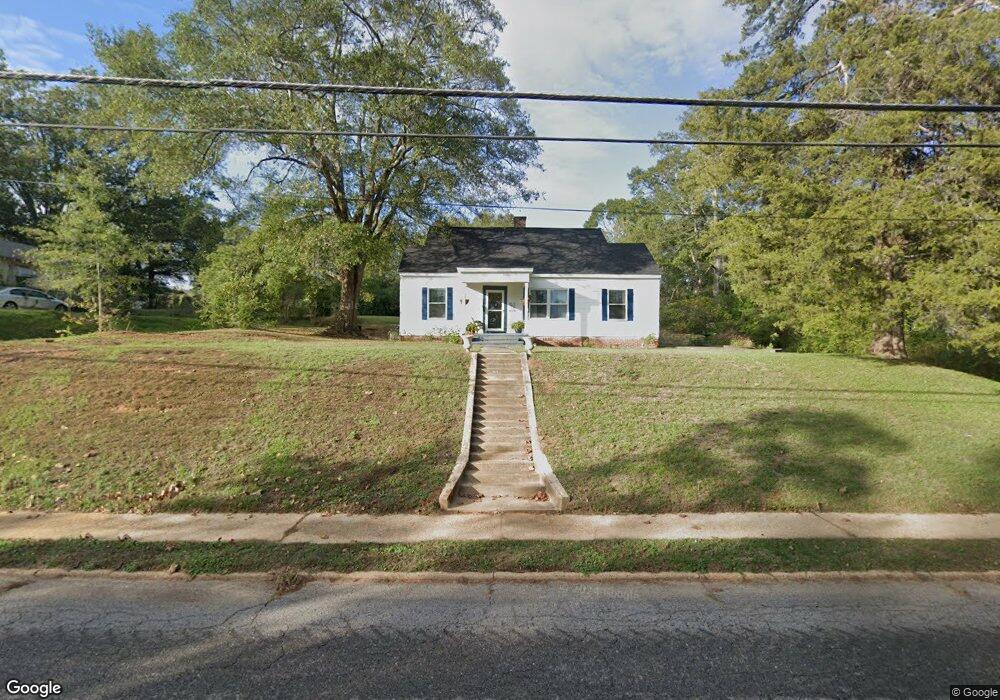
442 Myrtle St E Philadelphia, MS 39350
Estimated Value: $107,452 - $132,000
Studio
2
Baths
1,709
Sq Ft
$70/Sq Ft
Est. Value
About This Home
This home is located at 442 Myrtle St E, Philadelphia, MS 39350 and is currently estimated at $119,363, approximately $69 per square foot. 442 Myrtle St E is a home located in Neshoba County with nearby schools including Philadelphia Elementary School, Philadelphia Middle School, and Philadelphia High School.
Ownership History
Date
Name
Owned For
Owner Type
Purchase Details
Closed on
Mar 19, 2020
Sold by
Kirkland Tony and Kirkland Jerry Ann
Bought by
Lewis Mary
Current Estimated Value
Home Financials for this Owner
Home Financials are based on the most recent Mortgage that was taken out on this home.
Original Mortgage
$45,000
Outstanding Balance
$39,778
Interest Rate
3.4%
Mortgage Type
Unknown
Estimated Equity
$79,585
Purchase Details
Closed on
Jul 29, 2019
Sold by
Kirkland Tony M and Yates Joshua Shawn
Bought by
Kirkland Tony M and Kirkland Jerry Ann
Purchase Details
Closed on
Aug 14, 2018
Bought by
Yates Joshua and Yates Athena
Home Financials for this Owner
Home Financials are based on the most recent Mortgage that was taken out on this home.
Original Mortgage
$127,645
Interest Rate
4.59%
Create a Home Valuation Report for This Property
The Home Valuation Report is an in-depth analysis detailing your home's value as well as a comparison with similar homes in the area
Home Values in the Area
Average Home Value in this Area
Purchase History
| Date | Buyer | Sale Price | Title Company |
|---|---|---|---|
| Lewis Mary | -- | -- | |
| Kirkland Tony M | -- | -- | |
| Yates Joshua | -- | -- |
Source: Public Records
Mortgage History
| Date | Status | Borrower | Loan Amount |
|---|---|---|---|
| Open | Lewis Mary | $45,000 | |
| Previous Owner | Yates Joshua | $127,645 | |
| Previous Owner | Yates Joshua | -- | |
| Previous Owner | Yates Joshua | $39,788 |
Source: Public Records
Tax History
| Year | Tax Paid | Tax Assessment Tax Assessment Total Assessment is a certain percentage of the fair market value that is determined by local assessors to be the total taxable value of land and additions on the property. | Land | Improvement |
|---|---|---|---|---|
| 2025 | -- | $7,592 | $0 | $0 |
| 2024 | -- | $7,583 | $0 | $0 |
| 2023 | -- | $7,107 | $0 | $0 |
| 2022 | $956 | $7,107 | $0 | $0 |
| 2021 | $956 | $7,014 | $0 | $0 |
| 2020 | $1,450 | $10,521 | $0 | $0 |
| 2019 | $653 | $6,819 | $0 | $0 |
| 2018 | $643 | $6,819 | $0 | $0 |
| 2017 | $681 | $6,819 | $0 | $0 |
| 2016 | $681 | $6,819 | $0 | $0 |
| 2015 | -- | $6,779 | $0 | $0 |
| 2014 | -- | $6,779 | $0 | $0 |
Source: Public Records
Map
Nearby Homes
- 423 Pecan Ave
- 104 Martin Ave
- 431 Crockett Ave
- 521 Holland Ave
- 437C Pecan Ave
- 311 Range Ave
- 0 Columbus Ave
- 319 Range Ave
- 553 State Ave
- 551 State Ave
- 408 Hospital St
- 01 Mississippi 19
- 284 Byrd Ave N
- 524 Blount St
- 1106 Myrtle St E
- 738 Forest Park Cir
- 735 Forest Park Cir
- 128 Woodcrest Ave
- 568 Center Ave
- 588 Holland Ave
- 440 Myrtle St E
- 452 Myrtle St E
- 405 Crockett Ave
- 409 Crockett Ave
- 402 Crockett Ave
- 404 Crockett Ave
- 411 Crockett Ave
- 458 E Myrtle St
- 455 Myrtle St E
- 408 Crockett Ave
- 459 Myrtle St E
- 443 Myrtle St E
- 410 Crockett Ave
- 460 Myrtle St E
- 412 Crockett Ave
- 563 E Main St
- 0 E Highway 571 Unit 1289010
- 446 E Beacon St
- 414 Crockett Ave
- 417 Pecan Ave
Your Personal Tour Guide
Ask me questions while you tour the home.