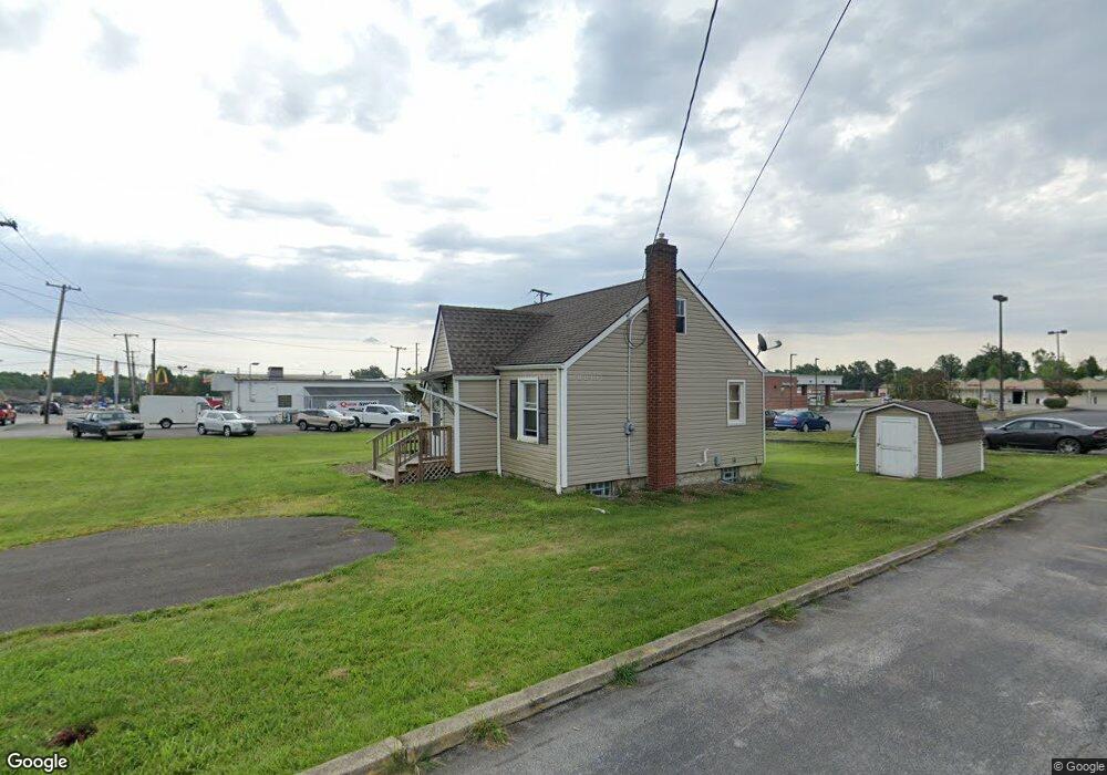
4423 New Rd Youngstown, OH 44515
Austintown NeighborhoodEstimated Value: $141,789 - $214,000
2
Beds
1
Bath
1,040
Sq Ft
$165/Sq Ft
Est. Value
About This Home
This home is located at 4423 New Rd, Youngstown, OH 44515 and is currently estimated at $171,947, approximately $165 per square foot. 4423 New Rd is a home located in Mahoning County with nearby schools including Austintown Elementary School, Austintown Intermediate School, and Austintown Middle School.
Ownership History
Date
Name
Owned For
Owner Type
Purchase Details
Closed on
May 16, 2023
Sold by
Bassil Louis
Bought by
Bassil Fabio and Kale Jessica
Current Estimated Value
Purchase Details
Closed on
Oct 30, 2014
Sold by
Lazazzera Michael Anthony and Lazazzera Melinda
Bought by
Bassil Louis
Home Financials for this Owner
Home Financials are based on the most recent Mortgage that was taken out on this home.
Original Mortgage
$50,000
Interest Rate
4.1%
Mortgage Type
Future Advance Clause Open End Mortgage
Purchase Details
Closed on
May 3, 2003
Sold by
Lazazzera Tracy Swanson
Bought by
Lazazzera Michael Anthony
Purchase Details
Closed on
May 12, 2000
Sold by
Polish Elizabeth L and Polish Louis J
Bought by
Lazazzera Michael
Purchase Details
Closed on
Sep 3, 1969
Bought by
Polish Elizabeth L
Create a Home Valuation Report for This Property
The Home Valuation Report is an in-depth analysis detailing your home's value as well as a comparison with similar homes in the area
Home Values in the Area
Average Home Value in this Area
Purchase History
| Date | Buyer | Sale Price | Title Company |
|---|---|---|---|
| Bassil Fabio | -- | -- | |
| Bassil Louis | $70,000 | Attorney | |
| Lazazzera Michael Anthony | -- | -- | |
| Lazazzera Michael | $50,000 | -- | |
| Polish Elizabeth L | -- | -- |
Source: Public Records
Mortgage History
| Date | Status | Borrower | Loan Amount |
|---|---|---|---|
| Previous Owner | Bassil Louis | $50,000 |
Source: Public Records
Tax History Compared to Growth
Tax History
| Year | Tax Paid | Tax Assessment Tax Assessment Total Assessment is a certain percentage of the fair market value that is determined by local assessors to be the total taxable value of land and additions on the property. | Land | Improvement |
|---|---|---|---|---|
| 2024 | $1,599 | $34,110 | $23,110 | $11,000 |
| 2023 | $1,575 | $34,110 | $23,110 | $11,000 |
| 2022 | $1,563 | $27,120 | $15,140 | $11,980 |
| 2021 | $1,564 | $27,120 | $15,140 | $11,980 |
| 2020 | $1,570 | $27,120 | $15,140 | $11,980 |
| 2019 | $1,540 | $24,220 | $13,520 | $10,700 |
| 2018 | $1,485 | $24,220 | $13,520 | $10,700 |
| 2017 | $1,495 | $24,220 | $13,520 | $10,700 |
| 2016 | $1,508 | $24,400 | $14,420 | $9,980 |
| 2015 | $1,536 | $24,400 | $14,420 | $9,980 |
| 2014 | $1,461 | $24,260 | $14,280 | $9,980 |
| 2013 | $1,447 | $24,260 | $14,280 | $9,980 |
Source: Public Records
Map
Nearby Homes
- 4314 Kerrybrook Dr
- 4262 Pembrook Rd
- 4235 Patricia Ave
- 4234 Burkey Rd
- 4241 Wedgewood Dr
- 4289 Wedgewood Dr
- 2414 Ardenwood Place
- 4102 Burkey Rd
- 2493 Frostwood Dr
- 1439 Bexley Dr
- 40 Woodleigh Ct
- 532 Westgate Blvd
- 3890 Ayrshire Dr
- 603 S Raccoon Rd Unit 14
- 603 S Raccoon Rd Unit 9
- 603 S Raccoon Rd Unit 61
- 4674 Barrington Dr
- 3913 Claridge Dr
- 3852 Edinburgh Dr
- 2388 Innwood Dr