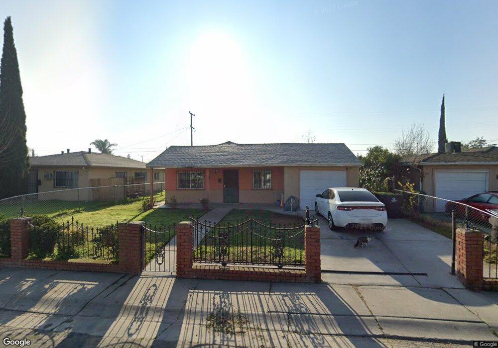
444 Howard St Stockton, CA 95206
Seaport NeighborhoodEstimated Value: $225,000 - $300,000
3
Beds
1
Bath
900
Sq Ft
$297/Sq Ft
Est. Value
About This Home
This home is located at 444 Howard St, Stockton, CA 95206 and is currently estimated at $267,436, approximately $297 per square foot. 444 Howard St is a home located in San Joaquin County with nearby schools including Dolores Huerta Elementary School, Hazelton Elementary School, and McKinley Elementary School.
Ownership History
Date
Name
Owned For
Owner Type
Purchase Details
Closed on
Oct 26, 2021
Sold by
Marilu Santos
Bought by
Marilu Santos Living Trust
Current Estimated Value
Purchase Details
Closed on
Sep 11, 2013
Sold by
Nunez Marco A
Bought by
Nunez Betty Jean
Purchase Details
Closed on
Jul 12, 2012
Sold by
Santos Yolanda L and Patricia Solano Santos Revocab
Bought by
Santos Yolanda L and Nunez Betty Jean
Purchase Details
Closed on
Mar 23, 2010
Sold by
Santos Patricia S
Bought by
Santos Patricia S and The Patricia Solano Santos Rev
Purchase Details
Closed on
Mar 11, 1996
Sold by
Santos Jose Luis
Bought by
Santos Patricia S
Purchase Details
Closed on
Dec 19, 1994
Sold by
Santos Patricia S
Bought by
Santos Jose Luis
Create a Home Valuation Report for This Property
The Home Valuation Report is an in-depth analysis detailing your home's value as well as a comparison with similar homes in the area
Home Values in the Area
Average Home Value in this Area
Purchase History
| Date | Buyer | Sale Price | Title Company |
|---|---|---|---|
| Marilu Santos Living Trust | -- | Sekhon & Obryant | |
| Nunez Betty Jean | -- | Old Republic Title Company | |
| Gomez Emma | -- | Old Republic Title Company | |
| Santos Jose Luis | -- | Old Republic Title Company | |
| Vazquez Yolanda L | -- | Old Republic Title Company | |
| Guerrero Patricia | -- | Old Republic Title Company | |
| Santos Marilu | $50,000 | Old Republic Title Company | |
| Santos Yolanda L | -- | None Available | |
| Santos Patricia S | -- | None Available | |
| Santos Patricia S | -- | -- | |
| Santos Jose Luis | -- | -- |
Source: Public Records
Tax History Compared to Growth
Tax History
| Year | Tax Paid | Tax Assessment Tax Assessment Total Assessment is a certain percentage of the fair market value that is determined by local assessors to be the total taxable value of land and additions on the property. | Land | Improvement |
|---|---|---|---|---|
| 2025 | $4,241 | $78,992 | $22,435 | $56,557 |
| 2024 | $1,116 | $77,445 | $21,996 | $55,449 |
| 2023 | $1,090 | $75,927 | $21,565 | $54,362 |
| 2022 | $947 | $74,440 | $21,143 | $53,297 |
| 2021 | $910 | $72,981 | $20,729 | $52,252 |
| 2020 | $927 | $72,234 | $20,517 | $51,717 |
| 2019 | $924 | $70,818 | $20,115 | $50,703 |
| 2018 | $907 | $69,430 | $19,721 | $49,709 |
| 2017 | $860 | $68,070 | $19,335 | $48,735 |
| 2016 | $875 | $66,735 | $18,956 | $47,779 |
| 2014 | $834 | $64,446 | $18,306 | $46,140 |
Source: Public Records
Map
Nearby Homes
- 426 Howard St
- 1932 S Lincoln St
- 509 Howard St
- 332 Kolher St
- 407 W 7th St
- 314 Kolher St
- 364 W 7th St
- 220 Delhi Ave
- 544 W 9th St
- 2332 S Madison St
- 539 Buena Vida Ct
- 864 W 5th St
- 3504 French Camp Turnpike
- 231 E 5th St
- 2242 Port Trinity Cir
- 2624 S Monroe St
- 1926 S San Joaquin St
- 2723 S Van Buren St
- 1249 S Madison St
- 1156 Derrick Dr