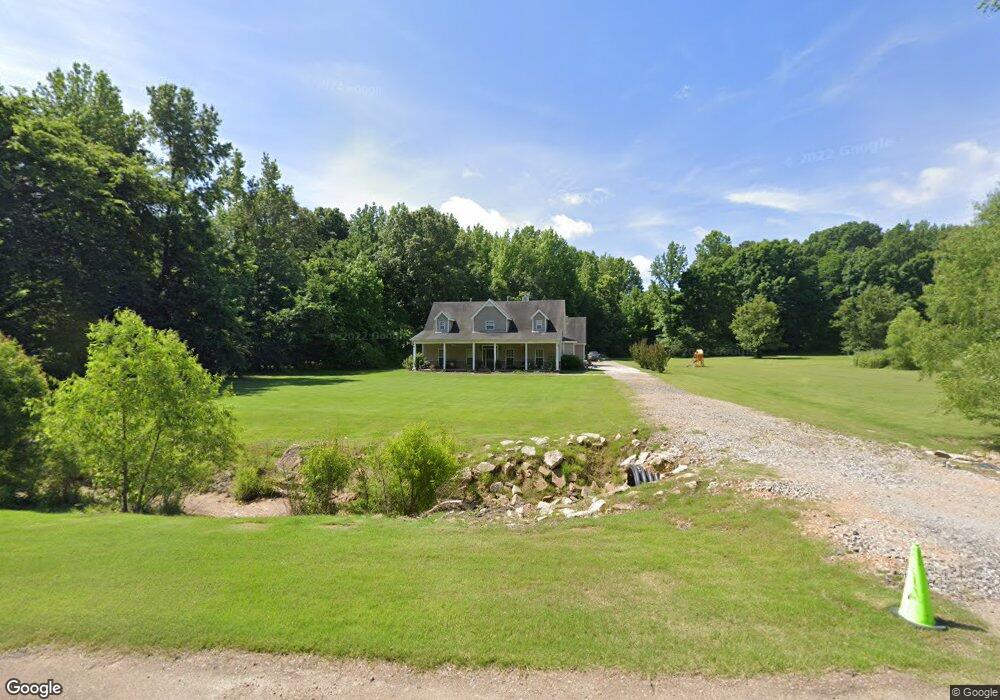
4465 River Run Rd Nesbit, MS 38651
Lewisburg NeighborhoodEstimated Value: $458,000 - $606,000
4
Beds
5
Baths
3,708
Sq Ft
$138/Sq Ft
Est. Value
About This Home
This home is located at 4465 River Run Rd, Nesbit, MS 38651 and is currently estimated at $511,826, approximately $138 per square foot. 4465 River Run Rd is a home located in DeSoto County with nearby schools including Lewisburg Primary School, Lewisburg Elementary School, and Lewisburg Middle School.
Ownership History
Date
Name
Owned For
Owner Type
Purchase Details
Closed on
Nov 30, 2010
Sold by
Orman Susan Renee and Mettler James
Bought by
Wade Kimberly and Wade James K
Current Estimated Value
Home Financials for this Owner
Home Financials are based on the most recent Mortgage that was taken out on this home.
Original Mortgage
$270,952
Outstanding Balance
$177,642
Interest Rate
4.3%
Mortgage Type
FHA
Estimated Equity
$334,184
Purchase Details
Closed on
Jan 24, 2008
Sold by
Orman Timothy W and Orman Susan Renee
Bought by
Orman Susan Renee and Mettler James
Create a Home Valuation Report for This Property
The Home Valuation Report is an in-depth analysis detailing your home's value as well as a comparison with similar homes in the area
Home Values in the Area
Average Home Value in this Area
Purchase History
| Date | Buyer | Sale Price | Title Company |
|---|---|---|---|
| Wade Kimberly | -- | First National Title Llc | |
| Orman Susan Renee | -- | Realty Title & Escrow Co Inc |
Source: Public Records
Mortgage History
| Date | Status | Borrower | Loan Amount |
|---|---|---|---|
| Open | Wade Kimberly | $270,952 |
Source: Public Records
Tax History
| Year | Tax Paid | Tax Assessment Tax Assessment Total Assessment is a certain percentage of the fair market value that is determined by local assessors to be the total taxable value of land and additions on the property. | Land | Improvement |
|---|---|---|---|---|
| 2025 | $2,150 | $29,699 | $1,900 | $27,799 |
| 2024 | $1,812 | $21,122 | $1,900 | $19,222 |
| 2023 | $1,812 | $21,122 | $0 | $0 |
| 2022 | $1,812 | $21,122 | $1,900 | $19,222 |
| 2021 | $1,812 | $21,122 | $1,900 | $19,222 |
| 2020 | $1,658 | $19,586 | $1,900 | $17,686 |
| 2019 | $1,658 | $19,586 | $1,900 | $17,686 |
| 2017 | $1,737 | $38,562 | $20,231 | $18,331 |
| 2016 | $1,737 | $20,231 | $1,900 | $18,331 |
| 2015 | $2,037 | $38,562 | $20,231 | $18,331 |
| 2014 | $1,737 | $20,231 | $0 | $0 |
| 2013 | $2,092 | $20,231 | $0 | $0 |
Source: Public Records
Map
Nearby Homes
- 0 Sandy Betts Rd
- 1134 Sandy Betts Rd
- 1735 Bakersfield Way
- 1762 Bakersfield Way
- 1755 Bakersfield Way
- 1789 Caribe Dr
- 1817 Caribe Dr
- 1722 Baisley Dr
- 4220 Adriane Cove
- 3770 Malone Rd
- 3771 Malone Rd
- 1721 Baisley Dr
- 1811 Baisley Dr
- 4276 Brooke Dr
- 1835 Baisley Dr
- 4809 Bakersfield Dr
- 2009 Plumas Dr
- 4609 Big Horn Dr S
- 560 N Malone
- 2024 Laughter Rd
- 1433 Sandy Betts Rd
- 7 River Run Dr
- 10 River Run Dr
- 1425 Cedar Cove
- 1 Sandy Betts Rd
- 4500 River Run Rd
- 1480 Cedar Cove
- 1320 Sandy Betts Rd
- 4405 River Run Dr
- 4405 River Run Rd
- 1475 Cedar Cove
- 4362 River Run Rd
- 1340 Sandy Betts Rd
- Lot 2 Sandy Betts Rd
- 0 Sandy Belts Rd
- 12 Sandy Betts Rd
- 1188 Sandy Betts Rd
- 4340 River Run Rd
- 4392 Sunset Rd
- 4514 Sunset Rd