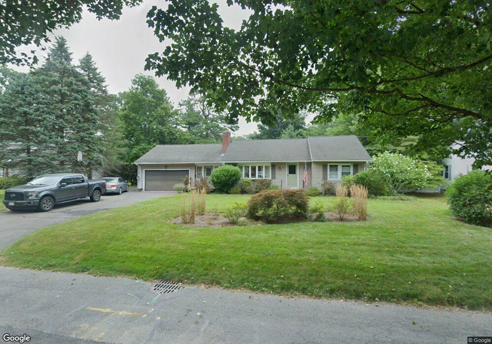
45 Whitmun Rd Longmeadow, MA 01106
Estimated Value: $408,000 - $488,000
3
Beds
1
Bath
1,401
Sq Ft
$316/Sq Ft
Est. Value
About This Home
This home is located at 45 Whitmun Rd, Longmeadow, MA 01106 and is currently estimated at $443,280, approximately $316 per square foot. 45 Whitmun Rd is a home located in Hampden County with nearby schools including Wolf Swamp Road School, Glenbrook Middle School, and Longmeadow High School.
Ownership History
Date
Name
Owned For
Owner Type
Purchase Details
Closed on
Mar 15, 1996
Sold by
Wilson Randy A and Wilson Joyce C
Bought by
Lantzakis Mark E and Lantzakis Rebecca S
Current Estimated Value
Home Financials for this Owner
Home Financials are based on the most recent Mortgage that was taken out on this home.
Original Mortgage
$118,400
Outstanding Balance
$4,618
Interest Rate
6.97%
Mortgage Type
Purchase Money Mortgage
Estimated Equity
$438,662
Create a Home Valuation Report for This Property
The Home Valuation Report is an in-depth analysis detailing your home's value as well as a comparison with similar homes in the area
Home Values in the Area
Average Home Value in this Area
Purchase History
| Date | Buyer | Sale Price | Title Company |
|---|---|---|---|
| Lantzakis Mark E | $148,000 | -- |
Source: Public Records
Mortgage History
| Date | Status | Borrower | Loan Amount |
|---|---|---|---|
| Open | Lantzakis Mark E | $7,000 | |
| Open | Lantzakis Mark E | $118,400 | |
| Previous Owner | Lantzakis Mark E | $87,300 | |
| Previous Owner | Lantzakis Mark E | $88,750 |
Source: Public Records
Tax History Compared to Growth
Tax History
| Year | Tax Paid | Tax Assessment Tax Assessment Total Assessment is a certain percentage of the fair market value that is determined by local assessors to be the total taxable value of land and additions on the property. | Land | Improvement |
|---|---|---|---|---|
| 2025 | $7,909 | $374,500 | $151,100 | $223,400 |
| 2024 | $7,745 | $374,500 | $151,100 | $223,400 |
| 2023 | $7,098 | $309,700 | $121,800 | $187,900 |
| 2022 | $7,180 | $291,400 | $121,800 | $169,600 |
| 2021 | $7,081 | $286,200 | $123,300 | $162,900 |
| 2020 | $7,169 | $296,100 | $116,100 | $180,000 |
| 2019 | $6,820 | $283,100 | $116,100 | $167,000 |
| 2018 | $6,331 | $260,100 | $139,700 | $120,400 |
| 2017 | $6,133 | $260,100 | $139,700 | $120,400 |
| 2016 | $6,063 | $249,200 | $133,400 | $115,800 |
| 2015 | $5,853 | $247,800 | $132,000 | $115,800 |
Source: Public Records
Map
Nearby Homes
- 25 Whitmun Rd
- 408 Maple Rd
- 95 Albemarle Rd
- 18 Sherwin Dr
- 95 Tedford Dr
- 35 Roosevelt Blvd
- 289 The Meadows
- 2 Nevins Ave
- 369 The Meadows
- 60 Roosevelt Blvd
- 151 Wolf Swamp Rd
- 87 Till St
- 195 Knollwood Dr
- 91 Till St
- 61 Prynne Ridge Rd
- 43 Liberty Ln
- 35 Liberty Ln
- 39 Liberty Ln
- 50 Liberty Ln
- 1423 Longmeadow St
- 51 Whitmun Rd
- 31 Whitmun Rd
- 178 Hazardville Rd
- 188 Hazardville Rd
- 166 Hazardville Rd
- 63 Whitmun Rd
- 46 Whitmun Rd
- 63 Whitmun Rd
- 36 Whitmun Rd
- 52 Whitmun Rd
- 198 Hazardville Rd
- 156 Hazardville Rd
- 26 Whitmun Rd
- 66 Whitmun Rd
- 75 Whitmun Rd
- 206 Hazardville Rd
- 148 Hazardville Rd
- 486 Maple Rd
- 74 Whitmun Rd
- 460 Maple Rd