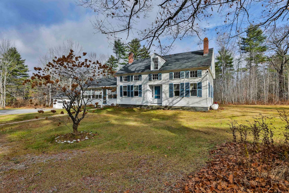
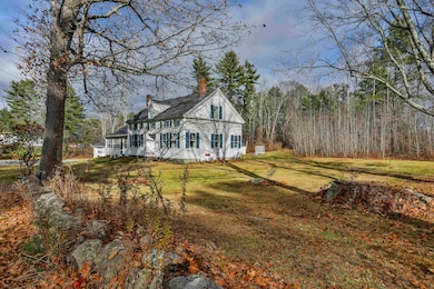
450 Weare Rd New Boston, NH 03070
Estimated payment $3,588/month
Highlights
- 5.72 Acre Lot
- Wooded Lot
- New Englander Architecture
- New Boston Central School Rated A-
- Softwood Flooring
- Main Floor Bedroom
About This Home
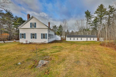
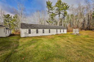
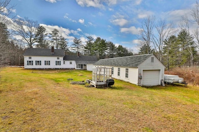
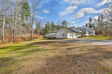
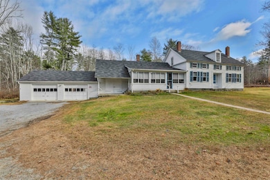
Come see this handsome 3 bedroom 1850 antique New Englander with many historic features inside and out. This nearly 6 acre river front property offers several opportunities including the rare possibility of subdivision, possible in-home business and more. The unique floor plan of this charming home includes a 1st floor bedroom, full bath and laundry for the option of main level living along with a sunny eat-in kitchen, flanked by front and back porches, walk-in pantry and a fabulous historic summer kitchen, formal dining room with fireplace and built-ins, a fireplaced living room and private study. A lovely open foyer staircase leads to 2 generously sized bedrooms on the 2nd floor as well as additional unfinished space for future expansion. If the oversized 2 car attached garage with a 3rd bay for storage is not enough space for you, check out the detached out building large enough for 5-6 cars, perfect for your car collection, toys or an expansive workshop! Don't wait, opportunity is knocking.
Listing Agent
East Key Realty Brokerage Phone: 603-620-2216 License #046074 Listed on: 11/21/2025

Home Details
Home Type
- Single Family
Est. Annual Taxes
- $9,483
Year Built
- Built in 1850
Lot Details
- 5.72 Acre Lot
- Corner Lot
- Wooded Lot
- Garden
- Property is zoned RA
Parking
- 2 Car Direct Access Garage
- Automatic Garage Door Opener
- Gravel Driveway
- 1 to 5 Parking Spaces
Home Design
- New Englander Architecture
- Stone Foundation
- Wood Frame Construction
- Metal Roof
Interior Spaces
- Property has 2 Levels
- Ceiling Fan
- Fireplace
- Dining Room
- Den
- Basement
- Interior Basement Entry
- Laundry on main level
Kitchen
- Walk-In Pantry
- Dishwasher
Flooring
- Softwood
- Carpet
- Vinyl
Bedrooms and Bathrooms
- 3 Bedrooms
- Main Floor Bedroom
- 1 Full Bathroom
Accessible Home Design
- Accessible Full Bathroom
- Kitchen has a 60 inch turning radius
- Hard or Low Nap Flooring
Outdoor Features
- Outdoor Storage
- Outbuilding
Schools
- New Boston Central Elementary School
- Mountain View Middle School
- Goffstown High School
Utilities
- Hot Water Heating System
- Heating System Uses Steam
- Drilled Well
- Septic Tank
- Cable TV Available
Listing and Financial Details
- Tax Lot 59
- Assessor Parcel Number 2
Map
Home Values in the Area
Average Home Value in this Area
Tax History
| Year | Tax Paid | Tax Assessment Tax Assessment Total Assessment is a certain percentage of the fair market value that is determined by local assessors to be the total taxable value of land and additions on the property. | Land | Improvement |
|---|---|---|---|---|
| 2024 | $9,483 | $398,600 | $166,900 | $231,700 |
| 2023 | $8,112 | $398,600 | $166,900 | $231,700 |
| 2022 | $7,645 | $398,600 | $166,900 | $231,700 |
| 2021 | $7,374 | $398,600 | $166,900 | $231,700 |
| 2020 | $7,343 | $304,800 | $115,600 | $189,200 |
| 2019 | $7,635 | $304,800 | $115,600 | $189,200 |
| 2018 | $7,276 | $304,800 | $115,600 | $189,200 |
| 2017 | $7,225 | $304,800 | $115,600 | $189,200 |
| 2016 | $13,401 | $304,800 | $115,600 | $189,200 |
| 2015 | $7,522 | $281,600 | $108,700 | $172,900 |
| 2014 | $7,167 | $281,600 | $108,700 | $172,900 |
| 2013 | $6,826 | $281,600 | $108,700 | $172,900 |
Property History
| Date | Event | Price | List to Sale | Price per Sq Ft |
|---|---|---|---|---|
| 11/21/2025 11/21/25 | For Sale | $529,900 | -- | $281 / Sq Ft |
Purchase History
| Date | Type | Sale Price | Title Company |
|---|---|---|---|
| Warranty Deed | -- | None Available | |
| Warranty Deed | -- | -- |
Mortgage History
| Date | Status | Loan Amount | Loan Type |
|---|---|---|---|
| Previous Owner | $20,000 | Unknown |
Source: PrimeMLS
MLS Number: 5070432
APN: NBOS-000002-000059
Disclaimer: Certain information contained herein is derived from information provided by parties other than Homes.com. All information provided is deemed reliable, but is not guaranteed to be accurate and should be independently verified.
![]() Copyright 2025 PrimeMLS, Inc. All rights reserved. This information is deemed reliable, but not guaranteed. The data relating to real estate displayed on this display comes in part from the IDX Program of PrimeMLS. The information being provided is for consumers’ personal, non-commercial use and may not be used for any purpose other than to identify prospective properties consumers may be interested in purchasing.
Copyright 2025 PrimeMLS, Inc. All rights reserved. This information is deemed reliable, but not guaranteed. The data relating to real estate displayed on this display comes in part from the IDX Program of PrimeMLS. The information being provided is for consumers’ personal, non-commercial use and may not be used for any purpose other than to identify prospective properties consumers may be interested in purchasing.
- 342 Weare Rd
- 95 Wright Dr
- 179 Oak Hill Rd
- 34 Lull Rd
- 77 Gould Rd
- 93 Daniels Rd
- 103 Renshaw Rd
- Lot 6-40-12 River Rd
- 238 Old Francestown Rd
- 174 S Stark Hwy Unit 13
- 174 S Stark Hwy Unit 23
- 29 N Riverdale Rd
- 624 S Stark Hwy
- 242 Colby Rd
- 54 Briar Hill Rd
- 61 River Rd
- 196 Deering Center Rd
- 252 Clark Hill Rd
- 16 Meetinghouse Hill Rd
- 1 Old Coach Rd
- 115 High Rock Rd Unit A
- 15 Mountain Rd Unit 201
- 15 Mountain Rd Unit 204
- 15 Mountain Rd Unit 105
- 15 Mountain Rd Unit 106
- 15 Mountain Rd Unit 102
- 15 Mountain Rd Unit 203
- 15 Mountain Rd Unit 205
- 15 Mountain Rd Unit 101
- 15 Mountain Rd Unit 202
- 15 Factory St
- 57 S Mast St Unit 2
- 55 Holbrook Hill Rd
- 29 Center St Unit 7
- 29 Center St Unit 5
- 45 Greer Rd Unit 1
- 49 Greer Rd Unit 49 A Greer Road
- 86 Reservoir Dr
- 5 Timberwood Dr Unit 106
- 5 Timberwood Dr Unit 207