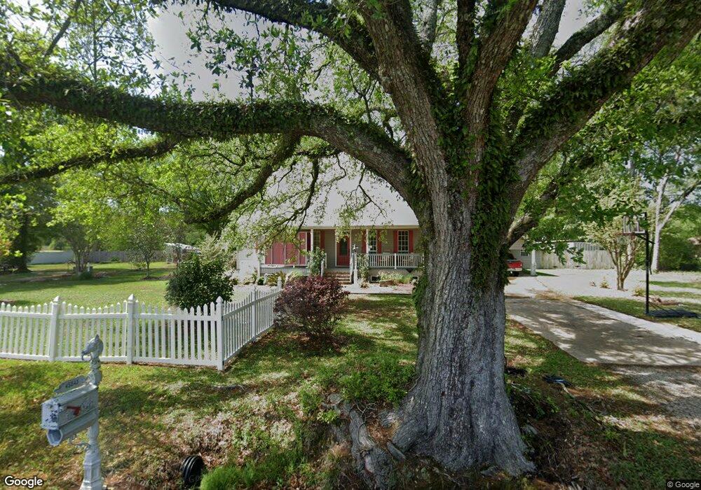
45043 Robertson Rd Robert, LA 70455
Estimated Value: $232,000 - $262,000
3
Beds
2
Baths
2,060
Sq Ft
$120/Sq Ft
Est. Value
About This Home
This home is located at 45043 Robertson Rd, Robert, LA 70455 and is currently estimated at $246,792, approximately $119 per square foot. 45043 Robertson Rd is a home located in Tangipahoa Parish with nearby schools including Hammond Eastside Magnet and Hammond High Magnet School.
Ownership History
Date
Name
Owned For
Owner Type
Purchase Details
Closed on
Jul 10, 2023
Sold by
Wells Sheila M and Wells Ronald E
Bought by
Ronald E Wells Revocable Living Trust and Sheila M Wells Revocable Living Trust
Current Estimated Value
Purchase Details
Closed on
Jan 13, 2011
Sold by
Breedlove Lloyd Oneal and Breedlove Karla Norris
Bought by
Zeringue Sheila Braud
Home Financials for this Owner
Home Financials are based on the most recent Mortgage that was taken out on this home.
Original Mortgage
$85,000
Interest Rate
4.84%
Mortgage Type
Future Advance Clause Open End Mortgage
Purchase Details
Closed on
Jul 31, 2008
Sold by
Laurie William F
Bought by
Breedlove Karla Norris and Breedlove Lloyd O
Home Financials for this Owner
Home Financials are based on the most recent Mortgage that was taken out on this home.
Original Mortgage
$100,000
Interest Rate
6.47%
Mortgage Type
New Conventional
Create a Home Valuation Report for This Property
The Home Valuation Report is an in-depth analysis detailing your home's value as well as a comparison with similar homes in the area
Purchase History
| Date | Buyer | Sale Price | Title Company |
|---|---|---|---|
| Ronald E Wells Revocable Living Trust | -- | None Listed On Document | |
| Zeringue Sheila Braud | $170,000 | Crescent Title Llc | |
| Breedlove Karla Norris | $176,500 | None Available |
Source: Public Records
Mortgage History
| Date | Status | Borrower | Loan Amount |
|---|---|---|---|
| Previous Owner | Zeringue Sheila Braud | $85,000 | |
| Previous Owner | Breedlove Karla Norris | $100,000 |
Source: Public Records
Tax History
| Year | Tax Paid | Tax Assessment Tax Assessment Total Assessment is a certain percentage of the fair market value that is determined by local assessors to be the total taxable value of land and additions on the property. | Land | Improvement |
|---|---|---|---|---|
| 2025 | $1,467 | $15,172 | $1,200 | $13,972 |
| 2024 | $1,461 | $15,172 | $1,200 | $13,972 |
| 2023 | $1,473 | $15,172 | $1,200 | $13,972 |
| 2022 | $1,473 | $15,172 | $1,200 | $13,972 |
| 2021 | $751 | $15,172 | $1,200 | $13,972 |
| 2020 | $1,473 | $15,172 | $1,200 | $13,972 |
| 2019 | $1,469 | $15,172 | $1,200 | $13,972 |
| 2018 | $1,473 | $15,172 | $1,200 | $13,972 |
| 2017 | $1,473 | $15,172 | $1,200 | $13,972 |
| 2016 | $1,473 | $15,172 | $1,200 | $13,972 |
| 2015 | $776 | $15,482 | $1,200 | $14,282 |
| 2014 | $728 | $15,482 | $1,200 | $14,282 |
Source: Public Records
Map
Nearby Homes
- 0 Highway 190 Hwy E Unit 2428618
- 0 Highway 190 Hwy E Unit 2469869
- 0 Highway 190 Hwy E Unit 2507528
- Lot 265 Arbor Dr
- 23547 Heritage Acres Ln
- 26.85 Acres Heritage Acres Ln
- 23483 Heritage Acres Ln
- PAR 1-B Highway 190
- PAR 1-D Highway 190
- PAR 1-C Highway 190
- PAR 1-A Highway 190
- 6.40 ACRE TRACT - Cypress Ln
- 45267 Coleman Rd
- 45269 Coleman Rd
- 0 Stepp Rd
- 24031 Highway 190 East None
- 24031 U S 190
- 24031 U S Highway 190
- 24031 Highway 190 E
- 45065 Robertson Rd
- 23549 Highway 190 E
- 23549 Highway 190 E
- 45089 Robertson Rd
- 23545 Highway 190 E
- 24074 Highway 190 E
- 45113 Robertson Rd
- 23515 Highway 190 E
- 23010 U S Highway 190
- 0 Highway 190 Hwy E Unit BR201217042
- 0 Highway 190 Hwy E Unit BR2016008880
- 0 Highway 190 Hwy E Unit NO493710
- 0 Highway 190 Hwy E Unit NO763681
- 0 Highway 190 Hwy E Unit NO677908
- 0 Highway 190 Hwy E Unit NO718250
- 0 Highway 190 Hwy E Unit NO282449
Your Personal Tour Guide
Ask me questions while you tour the home.