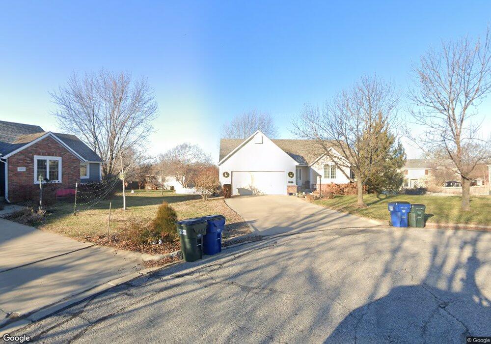
4512 Range Ct Lawrence, KS 66049
Estimated Value: $405,926 - $442,000
4
Beds
3
Baths
2,901
Sq Ft
$147/Sq Ft
Est. Value
About This Home
This home is located at 4512 Range Ct, Lawrence, KS 66049 and is currently estimated at $426,482, approximately $147 per square foot. 4512 Range Ct is a home located in Douglas County with nearby schools including Quail Run Elementary School, West Middle School, and Lawrence Free State High School.
Ownership History
Date
Name
Owned For
Owner Type
Purchase Details
Closed on
May 9, 2012
Sold by
Baringer Joseph and Baringer Philip
Bought by
Cooper Brian R and Vallejo Cooper Natasha I
Current Estimated Value
Home Financials for this Owner
Home Financials are based on the most recent Mortgage that was taken out on this home.
Original Mortgage
$201,600
Outstanding Balance
$139,679
Interest Rate
3.9%
Mortgage Type
New Conventional
Estimated Equity
$286,804
Create a Home Valuation Report for This Property
The Home Valuation Report is an in-depth analysis detailing your home's value as well as a comparison with similar homes in the area
Purchase History
| Date | Buyer | Sale Price | Title Company |
|---|---|---|---|
| Cooper Brian R | -- | Kansas Secured Title |
Source: Public Records
Mortgage History
| Date | Status | Borrower | Loan Amount |
|---|---|---|---|
| Open | Cooper Brian R | $201,600 |
Source: Public Records
Tax History
| Year | Tax Paid | Tax Assessment Tax Assessment Total Assessment is a certain percentage of the fair market value that is determined by local assessors to be the total taxable value of land and additions on the property. | Land | Improvement |
|---|---|---|---|---|
| 2025 | $5,800 | $46,575 | $7,475 | $39,100 |
| 2024 | $5,679 | $45,609 | $7,475 | $38,134 |
| 2023 | $5,520 | $42,838 | $6,900 | $35,938 |
| 2022 | $5,062 | $39,043 | $6,900 | $32,143 |
| 2021 | $4,442 | $33,235 | $5,980 | $27,255 |
| 2020 | $4,262 | $32,062 | $5,980 | $26,082 |
| 2019 | $4,062 | $30,602 | $5,060 | $25,542 |
| 2018 | $3,994 | $29,877 | $4,600 | $25,277 |
| 2017 | $4,013 | $29,682 | $4,600 | $25,082 |
| 2016 | $3,808 | $29,429 | $3,450 | $25,979 |
| 2015 | $3,747 | $28,957 | $3,450 | $25,507 |
| 2014 | $3,705 | $28,911 | $3,450 | $25,461 |
Source: Public Records
Map
Nearby Homes
- 416 Eldridge St
- 125 Sharon Dr
- 237 Landon Ct
- 3921 Monterey Place
- 4624 Hearthside Dr
- 4207 Timberline Ct
- 904 Moundridge Dr
- 145 N Fall Creek Dr
- 213 Stockade St
- 3712 Running Ridge Dr
- 3720 Running Ridge Dr
- 3808 Pinnacle Cir
- 216 Stockade St
- 212 Stockade St
- 5007 Congressional Way
- 317 Tallgrass Ct
- 3922 Willshire Dr
- 205 Knotted Bend Ct
- 3712 Trail Rd
- 5237 Carson Dr
- 4609 Roundabout Cir
- 4509 Range Ct
- 4605 Roundabout Cir
- 4508 Range Ct
- 4613 Roundabout Cir
- 4601 Roundabout Cir
- 4505 Range Ct
- 4504 Range Ct
- 4516 Trail Rd
- 4512 Trail Rd
- 4520 Trail Rd
- 4513 Roundabout Cir
- 4508 Trail Rd
- 4509 Roundabout Cir
- 4501 Range Ct
- 4500 Range Ct
- 4505 Roundabout Cir
- 4504 Trail Rd
- 4604 Roundabout Cir
- 4608 Roundabout Cir
Your Personal Tour Guide
Ask me questions while you tour the home.