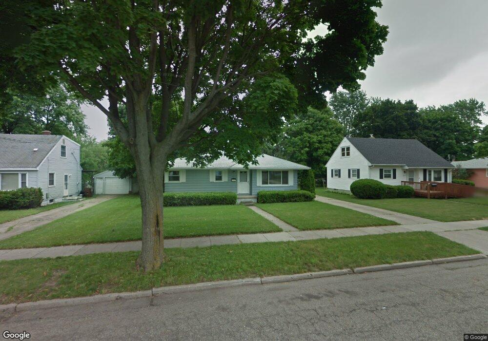
4515 Devonshire Ave Lansing, MI 48910
Old Everett NeighborhoodEstimated Value: $150,826 - $183,000
Studio
--
Bath
929
Sq Ft
$181/Sq Ft
Est. Value
About This Home
This home is located at 4515 Devonshire Ave, Lansing, MI 48910 and is currently estimated at $167,707, approximately $180 per square foot. 4515 Devonshire Ave is a home located in Ingham County with nearby schools including Kendon School, Attwood School, and Everett High School.
Ownership History
Date
Name
Owned For
Owner Type
Purchase Details
Closed on
May 9, 2017
Sold by
Mcwilliams John L
Bought by
Mcwilliams John L and John L Mcwilliams Trust
Current Estimated Value
Purchase Details
Closed on
Apr 28, 2000
Sold by
Poole June A and Poole Richard N
Bought by
Mcwilliams John L
Home Financials for this Owner
Home Financials are based on the most recent Mortgage that was taken out on this home.
Original Mortgage
$40,000
Outstanding Balance
$13,918
Interest Rate
8.24%
Mortgage Type
Purchase Money Mortgage
Estimated Equity
$153,789
Create a Home Valuation Report for This Property
The Home Valuation Report is an in-depth analysis detailing your home's value as well as a comparison with similar homes in the area
Home Values in the Area
Average Home Value in this Area
Purchase History
| Date | Buyer | Sale Price | Title Company |
|---|---|---|---|
| Mcwilliams John L | -- | None Available | |
| Mcwilliams John L | $91,500 | -- |
Source: Public Records
Mortgage History
| Date | Status | Borrower | Loan Amount |
|---|---|---|---|
| Open | Mcwilliams John L | $40,000 |
Source: Public Records
Tax History
| Year | Tax Paid | Tax Assessment Tax Assessment Total Assessment is a certain percentage of the fair market value that is determined by local assessors to be the total taxable value of land and additions on the property. | Land | Improvement |
|---|---|---|---|---|
| 2025 | $3,538 | $72,100 | $12,900 | $59,200 |
| 2024 | $28 | $69,900 | $12,900 | $57,000 |
| 2023 | $3,317 | $62,600 | $12,900 | $49,700 |
| 2022 | $2,988 | $57,800 | $12,200 | $45,600 |
| 2021 | $2,926 | $54,700 | $7,600 | $47,100 |
| 2020 | $2,909 | $50,500 | $7,600 | $42,900 |
| 2019 | $2,789 | $49,100 | $7,600 | $41,500 |
| 2018 | $2,613 | $44,100 | $7,600 | $36,500 |
| 2017 | $2,152 | $44,100 | $7,600 | $36,500 |
| 2016 | $2,058 | $39,900 | $7,600 | $32,300 |
| 2015 | $2,058 | $38,300 | $15,276 | $23,024 |
| 2014 | $2,058 | $36,800 | $11,147 | $25,653 |
Source: Public Records
Map
Nearby Homes
- 1101 Kendon Dr
- 4719 S Pennsylvania Ave
- 4815 S Pennsylvania Ave
- 0 Glenwood Ave
- 4806 Lyncott Dr
- 801 Jessop Ave
- 810 Fenton St
- 1109 Barr Ave
- 817 Jessop Ave
- 3907 Glenwood Ave
- 709 Jessop Ave
- 629 Emily Ave
- 1115 Shirley St
- 600 E Cavanaugh Rd
- 705 Hunter Blvd
- 601 Jessop Ave
- 3533 Glenwood Ave
- 3603 Parkway Dr
- 522 E Cavanaugh Rd
- 2018 Worden St
- 4507 Devonshire Ave
- 4519 Devonshire Ave
- 4501 Devonshire Ave
- 4525 Devonshire Ave
- 4500 Devonshire Ave
- 4512 Devonshire Ave
- 4518 Devonshire Ave
- 4427 Devonshire Ave
- 4601 Devonshire Ave
- 4524 Devonshire Ave
- 1114 Samantha Ave
- 4609 Devonshire Ave
- 4600 Devonshire Ave
- 4421 Devonshire Ave
- 1106 Samantha Ave
- 4515 Alpha St
- 4420 Devonshire Ave
- 4519 Alpha St
- 4608 Devonshire Ave
- 4525 Alpha St
Your Personal Tour Guide
Ask me questions while you tour the home.