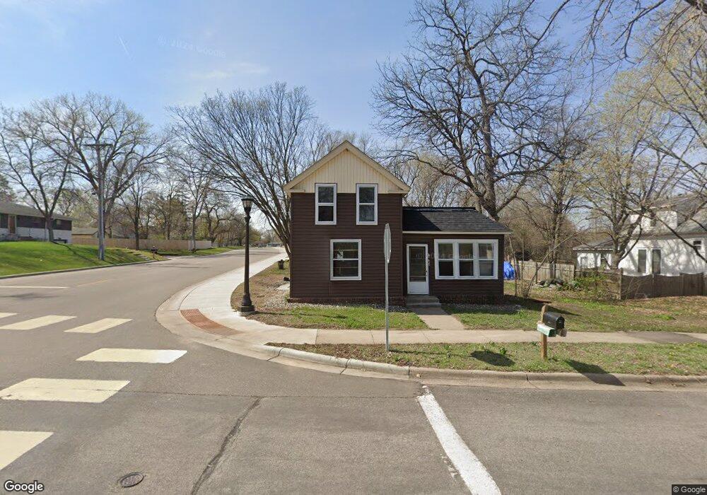
456 Independence Ave N Champlin, MN 55316
Estimated Value: $144,000 - $214,000
2
Beds
1
Bath
1,112
Sq Ft
$175/Sq Ft
Est. Value
About This Home
This home is located at 456 Independence Ave N, Champlin, MN 55316 and is currently estimated at $194,184, approximately $174 per square foot. 456 Independence Ave N is a home located in Hennepin County with nearby schools including Champlin-Brooklyn Park Academy, Jackson Middle School, and Champlin Park High School.
Ownership History
Date
Name
Owned For
Owner Type
Purchase Details
Closed on
Jan 28, 2021
Sold by
Wilmington Savings Fund Society Fsb
Bought by
Twin City Development Company Llc
Current Estimated Value
Purchase Details
Closed on
Mar 25, 2020
Sold by
Steiner Linda L and Steiner Robert Warren
Bought by
Guaranty Home Equity Corporation and Gb Home Equity
Purchase Details
Closed on
Feb 23, 1999
Sold by
Bankers Trust Cp Pf Ca
Bought by
Steiner Robert Warren and Steiner Linda J
Create a Home Valuation Report for This Property
The Home Valuation Report is an in-depth analysis detailing your home's value as well as a comparison with similar homes in the area
Home Values in the Area
Average Home Value in this Area
Purchase History
| Date | Buyer | Sale Price | Title Company |
|---|---|---|---|
| Twin City Development Company Llc | $85,800 | None Available | |
| Guaranty Home Equity Corporation | $77,475 | None Available | |
| Steiner Robert Warren | $21,500 | -- | |
| -- | $85,800 | -- |
Source: Public Records
Tax History
| Year | Tax Paid | Tax Assessment Tax Assessment Total Assessment is a certain percentage of the fair market value that is determined by local assessors to be the total taxable value of land and additions on the property. | Land | Improvement |
|---|---|---|---|---|
| 2024 | $1,445 | $120,700 | $87,000 | $33,700 |
| 2023 | $1,385 | $120,900 | $89,000 | $31,900 |
| 2022 | $2,163 | $105,000 | $78,000 | $27,000 |
| 2021 | $2,163 | $188,000 | $65,000 | $123,000 |
| 2020 | $0 | $173,000 | $56,000 | $117,000 |
| 2019 | $0 | $157,000 | $58,000 | $99,000 |
| 2018 | $0 | $133,000 | $49,000 | $84,000 |
| 2017 | $0 | $110,000 | $36,000 | $74,000 |
| 2016 | -- | $110,000 | $42,000 | $68,000 |
| 2015 | $1,239 | $110,000 | $37,000 | $73,000 |
| 2014 | -- | $100,000 | $40,000 | $60,000 |
Source: Public Records
Map
Nearby Homes
- 719 Keniston St N
- 704 Keniston St N
- 969 Creekwood Dr N
- 413 Orleans Ct N
- 701 Parkview Ln
- 1625 3rd Ave
- 431 Fremont St
- 413 Fremont St
- 216 Monroe St
- 809 Bradford Ave
- 1167 Benton St
- 2111 Green Ave
- 518 Western St
- 12972 Bauer Dr N
- 1319 7th Ln
- 2224 4th Ave
- 826 Elm St
- 2014 6th Ave
- 13360 Wellington Cir
- 614 Jackson St
- 452 Independence Ave N
- 564 Independence Ave N
- 457 Independence Ave N
- 453 Independence Ave N
- 563 Independence Ave N
- 101 Sunset Dr W
- 438 Independence Ave N
- 439 Independence Ave N
- 13 Dean Ave E
- 105 Sunset Dr W
- 14 Richardson Ave N
- 14 Dean Ave E
- 670 Independence Ave N
- 21 Dean Ave E
- 671 Independence Ave N
- 18 Richardson Ave N
- 107 Sunset Dr W
- 22 Dean Ave E
- 344 Independence Ave N
- XXX Curtis Rd
Your Personal Tour Guide
Ask me questions while you tour the home.