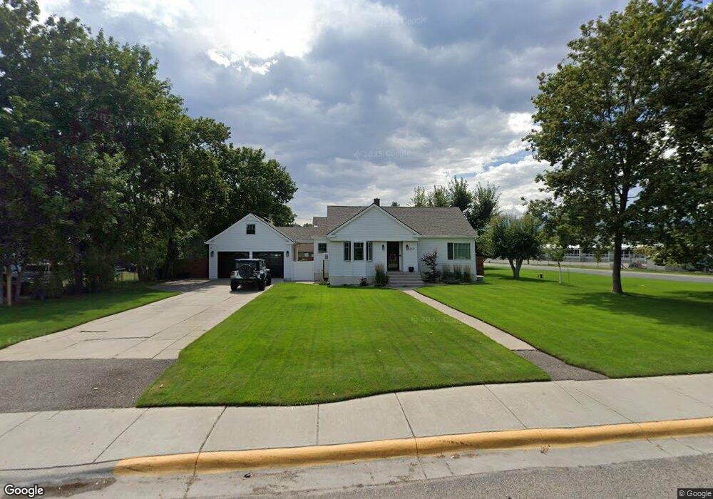
4570 Pride Ct Missoula, MT 59803
South 39th Street NeighborhoodEstimated Value: $341,000 - $568,000
3
Beds
2
Baths
1,408
Sq Ft
$295/Sq Ft
Est. Value
About This Home
This home is located at 4570 Pride Ct, Missoula, MT 59803 and is currently estimated at $415,090, approximately $294 per square foot. 4570 Pride Ct is a home located in Missoula County with nearby schools including Jeannette Rankin Elementary School, Meadow Hill Middle School, and Sentinel High School.
Ownership History
Date
Name
Owned For
Owner Type
Purchase Details
Closed on
Nov 3, 2010
Sold by
Fritz Betty Lou
Bought by
Robinson Jerry and Robinson Dee
Current Estimated Value
Purchase Details
Closed on
Aug 21, 2003
Sold by
Robinson Jadeen M
Bought by
Fritz Betty Lou
Home Financials for this Owner
Home Financials are based on the most recent Mortgage that was taken out on this home.
Original Mortgage
$102,200
Interest Rate
3.75%
Mortgage Type
Purchase Money Mortgage
Create a Home Valuation Report for This Property
The Home Valuation Report is an in-depth analysis detailing your home's value as well as a comparison with similar homes in the area
Home Values in the Area
Average Home Value in this Area
Purchase History
| Date | Buyer | Sale Price | Title Company |
|---|---|---|---|
| Robinson Jerry | -- | Tsi | |
| Fritz Betty Lou | -- | -- |
Source: Public Records
Mortgage History
| Date | Status | Borrower | Loan Amount |
|---|---|---|---|
| Previous Owner | Fritz Betty Lou | $102,200 | |
| Closed | Fritz Betty Lou | $32,800 |
Source: Public Records
Tax History
| Year | Tax Paid | Tax Assessment Tax Assessment Total Assessment is a certain percentage of the fair market value that is determined by local assessors to be the total taxable value of land and additions on the property. | Land | Improvement |
|---|---|---|---|---|
| 2025 | $3,957 | $352,870 | $131,500 | $221,370 |
| 2024 | $3,949 | $308,860 | $104,250 | $204,610 |
| 2023 | $3,679 | $324,530 | $104,250 | $220,280 |
| 2022 | $3,302 | $241,310 | $0 | $0 |
| 2021 | $2,932 | $241,310 | $0 | $0 |
| 2020 | $2,796 | $210,660 | $0 | $0 |
| 2019 | $2,787 | $210,660 | $0 | $0 |
| 2018 | $2,602 | $191,000 | $0 | $0 |
| 2017 | $2,558 | $191,000 | $0 | $0 |
| 2016 | $2,352 | $183,300 | $0 | $0 |
| 2015 | $2,177 | $183,300 | $0 | $0 |
| 2014 | $2,267 | $107,651 | $0 | $0 |
Source: Public Records
Map
Nearby Homes
- 4103 Rainbow Dr
- 2324 Cloverdale Dr
- 2320 Cloverdale Dr
- 2621 Highwood Dr
- 2404 Highwood Dr
- 2324 Southhills Dr
- 2309 Cloverdale Dr
- 2243 42nd St
- 2207 Garland Dr
- 3821 Dore Ln
- 127 Meadowlark Ct
- 2608 Gharrett St
- 2615 Gharrett St
- 3711 & 3715 Schilling
- 3521 Brooks St
- Nhn Hillview Way
- LOT 4 Miller Creek Rd
- LOT 2 Miller Creek Rd
- 5142 Clearview Way
- 3200 S Clark St
- 4570 Pride Ct
- 2634 Cardinal Dr
- 2640 Cardinal Dr
- 4550 Pride Ct
- 4550 Pride Ct
- 4575 Kaniksu Ct
- 2628 Cardinal Dr
- 4555 Kaniksu Ct
- 4590 Kaniksu Ct
- 2621 Briggs St
- 2621 Briggs St
- 2635 Cardinal Dr
- 4505 Kaniksu Ct
- 2629 Cardinal Dr
- 2612 Cardinal Dr
- 4570 Kaniksu Ct
- 2623 Cardinal Dr
- 4550 Kaniksu Ct
- 2610 Cardinal Dr
- 2615 Cardinal Dr
Your Personal Tour Guide
Ask me questions while you tour the home.