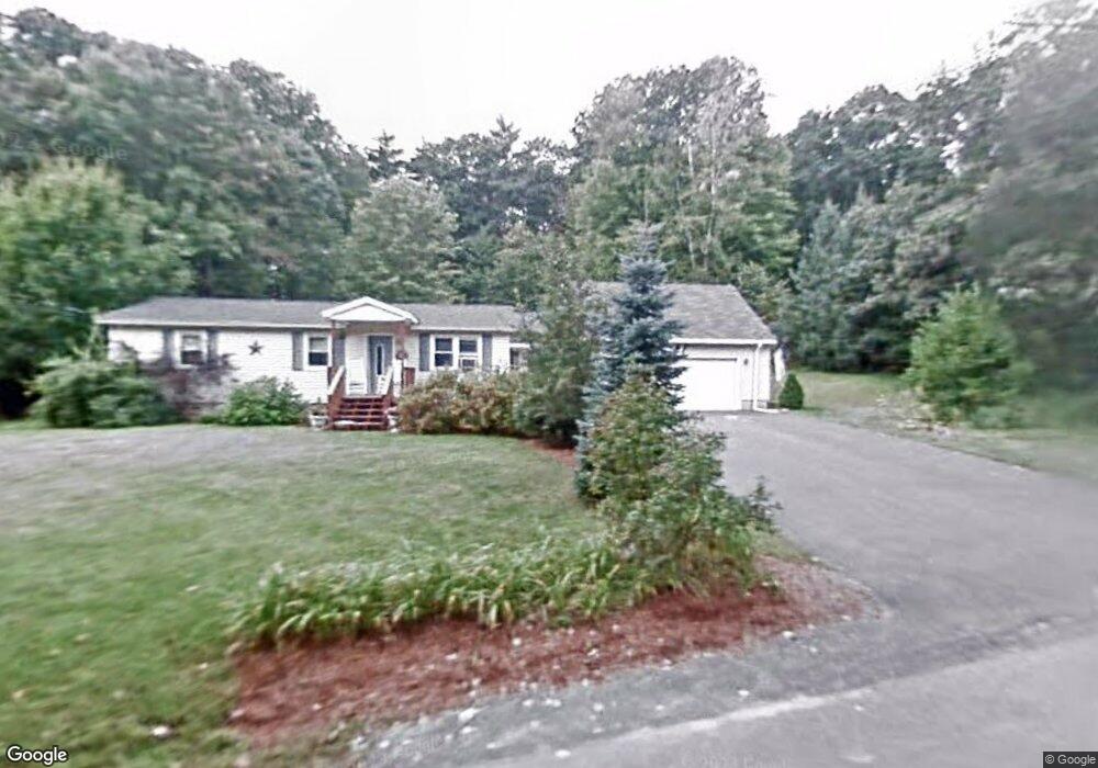
46 Forest Ln Boscawen, NH 03303
Estimated Value: $422,000 - $501,000
3
Beds
1
Bath
2,294
Sq Ft
$202/Sq Ft
Est. Value
About This Home
This home is located at 46 Forest Ln, Boscawen, NH 03303 and is currently estimated at $463,422, approximately $202 per square foot. 46 Forest Ln is a home located in Merrimack County with nearby schools including Boscawen Elementary School, Merrimack Valley Middle School, and Merrimack Valley High School.
Ownership History
Date
Name
Owned For
Owner Type
Purchase Details
Closed on
Apr 11, 2022
Sold by
Aubertine Amy L and Pellerin Robert A
Bought by
Aubertine Amy L and Aubertine Steven C
Current Estimated Value
Home Financials for this Owner
Home Financials are based on the most recent Mortgage that was taken out on this home.
Original Mortgage
$235,000
Outstanding Balance
$220,151
Interest Rate
4%
Mortgage Type
Adjustable Rate Mortgage/ARM
Estimated Equity
$243,271
Purchase Details
Closed on
Mar 29, 2002
Sold by
Beard Algie A and Beard Diane D
Bought by
Pellerin Amy L and Pellerin Robert A
Home Financials for this Owner
Home Financials are based on the most recent Mortgage that was taken out on this home.
Original Mortgage
$132,914
Interest Rate
6.88%
Create a Home Valuation Report for This Property
The Home Valuation Report is an in-depth analysis detailing your home's value as well as a comparison with similar homes in the area
Home Values in the Area
Average Home Value in this Area
Purchase History
| Date | Buyer | Sale Price | Title Company |
|---|---|---|---|
| Aubertine Amy L | -- | None Available | |
| Aubertine Amy L | -- | None Available | |
| Pellerin Amy L | $135,000 | -- | |
| Pellerin Amy L | $135,000 | -- |
Source: Public Records
Mortgage History
| Date | Status | Borrower | Loan Amount |
|---|---|---|---|
| Open | Aubertine Amy L | $235,000 | |
| Closed | Aubertine Amy L | $235,000 | |
| Previous Owner | Pellerin Amy L | $132,914 |
Source: Public Records
Tax History Compared to Growth
Tax History
| Year | Tax Paid | Tax Assessment Tax Assessment Total Assessment is a certain percentage of the fair market value that is determined by local assessors to be the total taxable value of land and additions on the property. | Land | Improvement |
|---|---|---|---|---|
| 2024 | $8,014 | $416,100 | $169,100 | $247,000 |
| 2023 | $8,085 | $416,100 | $169,100 | $247,000 |
| 2022 | $7,451 | $240,600 | $96,000 | $144,600 |
| 2021 | $6,828 | $240,600 | $96,000 | $144,600 |
| 2020 | $6,446 | $240,600 | $96,000 | $144,600 |
| 2019 | $6,766 | $240,600 | $96,000 | $144,600 |
| 2018 | $5,764 | $240,600 | $96,000 | $144,600 |
| 2017 | $5,979 | $199,500 | $65,700 | $133,800 |
| 2016 | $5,708 | $199,500 | $65,700 | $133,800 |
| 2015 | $5,865 | $199,500 | $65,700 | $133,800 |
| 2014 | $5,696 | $199,500 | $65,700 | $133,800 |
| 2013 | $5,398 | $199,500 | $65,700 | $133,800 |
Source: Public Records
Map
Nearby Homes
- 187 Intervale Rd
- 222 Daniel Webster Hwy
- 19 Bailey Dr
- 527 Northwest Rd
- 9 High St
- 254 King St
- 250 King St
- 437 High St
- 187 King St
- 293 Queen St
- 29 Duston Dr
- 57 Center Rd
- 299 Concord Rd
- Map 6, Lot 38 Chadwick Hill Rd
- 593 Prospect St
- 603 Prospect St
- 231 Mutton Rd
- 3A Red Oak Way Unit 3A
- 3B Red Oak Way
- 5A Red Oak Way Unit 5A