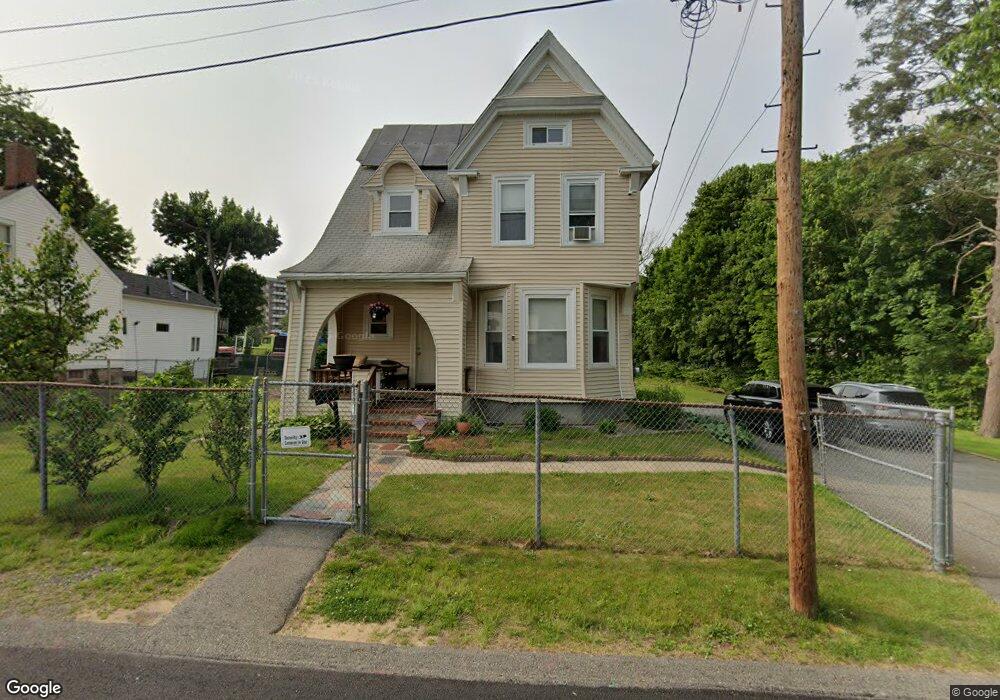
46 Watson St Brockton, MA 02301
Campello NeighborhoodEstimated Value: $495,000 - $785,000
3
Beds
1
Bath
2,407
Sq Ft
$251/Sq Ft
Est. Value
About This Home
This home is located at 46 Watson St, Brockton, MA 02301 and is currently estimated at $603,480, approximately $250 per square foot. 46 Watson St is a home located in Plymouth County with nearby schools including Gilmore Elementary School, Davis K-8 School, and John F. Kennedy Elementary School.
Ownership History
Date
Name
Owned For
Owner Type
Purchase Details
Closed on
Jul 14, 1995
Sold by
Fontes Joao V
Bought by
Pires Joao S and Pires Lourenca L
Current Estimated Value
Purchase Details
Closed on
Aug 13, 1993
Sold by
Dime Sb Ny
Bought by
Fontes Joao V
Purchase Details
Closed on
Mar 9, 1992
Sold by
Chabot Jeffrey A
Bought by
Dime Sb Of Ny Fsb
Purchase Details
Closed on
Jan 4, 1989
Sold by
Gillis David G
Bought by
Chabot Jeffrey A
Create a Home Valuation Report for This Property
The Home Valuation Report is an in-depth analysis detailing your home's value as well as a comparison with similar homes in the area
Home Values in the Area
Average Home Value in this Area
Purchase History
| Date | Buyer | Sale Price | Title Company |
|---|---|---|---|
| Pires Joao S | $50,000 | -- | |
| Fontes Joao V | $47,900 | -- | |
| Dime Sb Of Ny Fsb | $60,000 | -- | |
| Chabot Jeffrey A | $167,000 | -- |
Source: Public Records
Mortgage History
| Date | Status | Borrower | Loan Amount |
|---|---|---|---|
| Open | Chabot Jeffrey A | $140,000 | |
| Closed | Chabot Jeffrey A | $33,000 |
Source: Public Records
Tax History Compared to Growth
Tax History
| Year | Tax Paid | Tax Assessment Tax Assessment Total Assessment is a certain percentage of the fair market value that is determined by local assessors to be the total taxable value of land and additions on the property. | Land | Improvement |
|---|---|---|---|---|
| 2025 | $5,595 | $462,000 | $144,100 | $317,900 |
| 2024 | $5,193 | $432,000 | $144,100 | $287,900 |
| 2023 | $5,389 | $415,200 | $124,200 | $291,000 |
| 2022 | $4,769 | $341,400 | $113,100 | $228,300 |
| 2021 | $4,894 | $337,500 | $98,400 | $239,100 |
| 2020 | $4,503 | $297,200 | $88,000 | $209,200 |
| 2019 | $4,458 | $286,900 | $84,400 | $202,500 |
| 2018 | $4,142 | $257,900 | $84,400 | $173,500 |
| 2017 | $4,072 | $252,900 | $84,400 | $168,500 |
| 2016 | $3,856 | $222,100 | $83,200 | $138,900 |
| 2015 | $3,300 | $181,800 | $83,200 | $98,600 |
| 2014 | $3,289 | $181,400 | $83,200 | $98,200 |
Source: Public Records
Map
Nearby Homes
- 15 Otto St
- 40 Glen Ave
- 163 S Leyden St
- 60 Clifton Ave
- 29 Glendale Ave
- 223 Clinton St Unit 10
- 223 Clinton St Unit 3
- 1845 Main St
- 358 Copeland St
- 115 Market St
- 47 Southworth St
- 44 Country Club Dr
- 13 Finny's Way
- 94 Carl Ave
- 112 Hillside Ave
- 34 Carl Ave
- 103 Clinton St
- 122 Sinclair Rd
- 12 Paulin Ave
- 936 Warren Ave