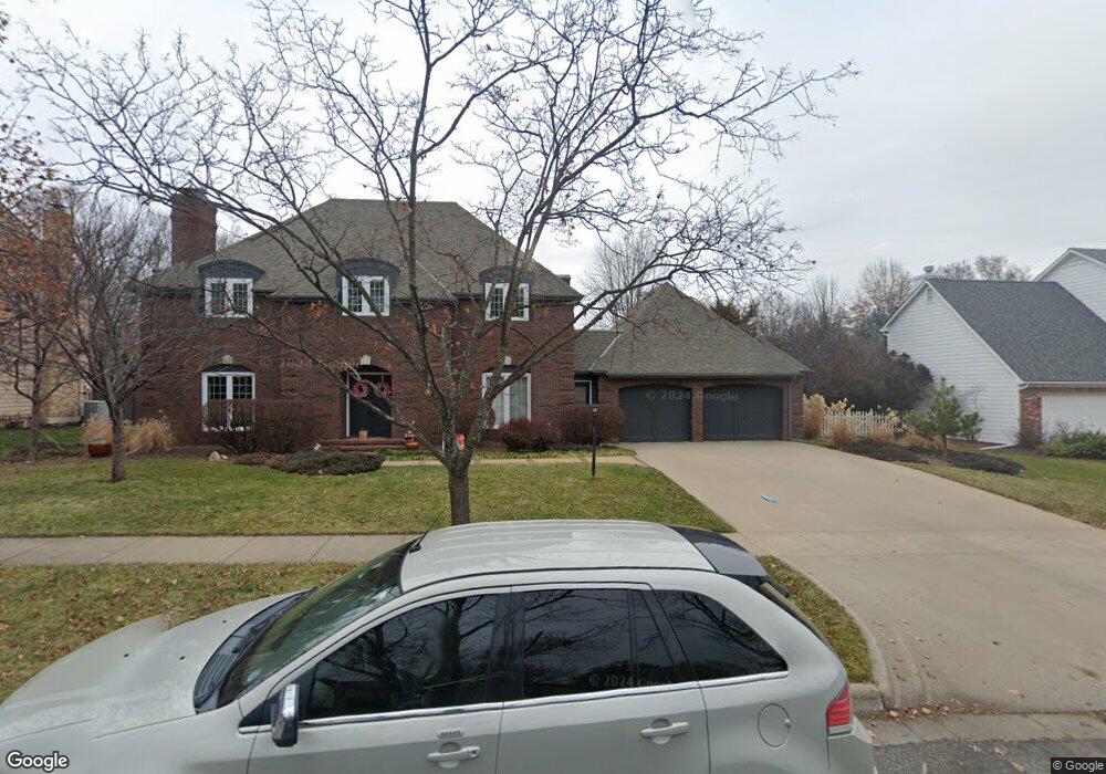
4620 Muirfield Dr Lawrence, KS 66047
Estimated Value: $514,000 - $566,000
3
Beds
4
Baths
3,347
Sq Ft
$162/Sq Ft
Est. Value
About This Home
This home is located at 4620 Muirfield Dr, Lawrence, KS 66047 and is currently estimated at $541,747, approximately $161 per square foot. 4620 Muirfield Dr is a home located in Douglas County with nearby schools including Sunflower Elementary School, Southwest Middle School, and Lawrence High School.
Ownership History
Date
Name
Owned For
Owner Type
Purchase Details
Closed on
Jan 19, 2011
Sold by
Peters Carol L and Freeman James D
Bought by
Brandt Ryan and Brandt Brandy
Current Estimated Value
Home Financials for this Owner
Home Financials are based on the most recent Mortgage that was taken out on this home.
Original Mortgage
$215,600
Outstanding Balance
$145,434
Interest Rate
4.56%
Mortgage Type
New Conventional
Estimated Equity
$396,313
Create a Home Valuation Report for This Property
The Home Valuation Report is an in-depth analysis detailing your home's value as well as a comparison with similar homes in the area
Home Values in the Area
Average Home Value in this Area
Purchase History
| Date | Buyer | Sale Price | Title Company |
|---|---|---|---|
| Brandt Ryan | -- | Ct |
Source: Public Records
Mortgage History
| Date | Status | Borrower | Loan Amount |
|---|---|---|---|
| Open | Brandt Ryan | $215,600 |
Source: Public Records
Tax History Compared to Growth
Tax History
| Year | Tax Paid | Tax Assessment Tax Assessment Total Assessment is a certain percentage of the fair market value that is determined by local assessors to be the total taxable value of land and additions on the property. | Land | Improvement |
|---|---|---|---|---|
| 2025 | $6,615 | $56,695 | $7,475 | $49,220 |
| 2024 | $6,615 | $52,902 | $7,475 | $45,427 |
| 2023 | $6,424 | $49,726 | $7,475 | $42,251 |
| 2022 | $6,286 | $48,317 | $7,475 | $40,842 |
| 2021 | $5,531 | $41,296 | $6,334 | $34,962 |
| 2020 | $5,562 | $41,733 | $6,334 | $35,399 |
| 2019 | $5,365 | $40,307 | $6,334 | $33,973 |
| 2018 | $4,854 | $36,236 | $6,334 | $29,902 |
| 2017 | $4,821 | $35,592 | $6,334 | $29,258 |
| 2016 | $4,349 | $33,557 | $5,173 | $28,384 |
| 2015 | $4,419 | $34,086 | $5,173 | $28,913 |
| 2014 | $4,376 | $34,086 | $5,173 | $28,913 |
Source: Public Records
Map
Nearby Homes
- 4617 Merion Ct
- 1608 Prestwick Dr
- 4709 Carmel Place
- 4206 Nicklaus Dr
- 1616 Prestwick Dr
- 2009 Riviera Ct
- 2101 Riviera Dr
- 2100 Inverness Dr
- 2109 Riviera Dr
- 4500 Bob Billings Pkwy Unit 408
- 4312 Wimbledon Dr
- 1601 Research Park Dr
- 1406 Brighton Cir Unit B
- 1908 Crossgate Dr
- 1580 Eldorado Dr
- 1204 Chadwick Ct
- 1315 Research Park Dr
- 1120 Oak Tree Dr
- 4400 Gretchen Ct
- 1300 Research Park Dr
- 4616 Muirfield Dr
- 4624 Muirfield Dr
- 4613 Merion Ct
- 4625 Muirfield Dr
- 4621 Muirfield Dr
- 4612 Muirfield Dr
- 4628 Muirfield Dr
- 1641 Merion Place
- 4616 Merion Ct
- 4629 Muirfield Dr
- 4609 Merion Ct
- 4617 Muirfield Dr
- 4608 Muirfield Dr
- 1637 Merion Place
- 4632 Muirfield Dr
- 1720 Troon Ln
- 4612 Merion Ct
- 1645 Merion Place
- 4613 Muirfield Dr
- 4605 Merion Ct