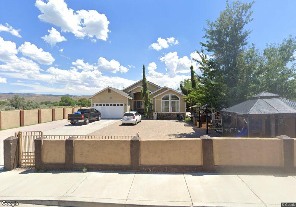
4637 Carter Ave Carson City, NV 89701
Riverview NeighborhoodEstimated Value: $691,755 - $773,000
3
Beds
3
Baths
2,208
Sq Ft
$326/Sq Ft
Est. Value
About This Home
This home is located at 4637 Carter Ave, Carson City, NV 89701 and is currently estimated at $719,939, approximately $326 per square foot. 4637 Carter Ave is a home located in Carson City with nearby schools including Empire Elementary School, Eagle Valley Middle School, and Carson High School.
Ownership History
Date
Name
Owned For
Owner Type
Purchase Details
Closed on
Oct 25, 2006
Sold by
Snelling Scott
Bought by
Leon Luis and Lozano Trinidad
Current Estimated Value
Home Financials for this Owner
Home Financials are based on the most recent Mortgage that was taken out on this home.
Original Mortgage
$372,000
Outstanding Balance
$221,152
Interest Rate
6.3%
Mortgage Type
Purchase Money Mortgage
Estimated Equity
$498,787
Purchase Details
Closed on
Feb 1, 2005
Sold by
Snelling Jillian
Bought by
Snelling Scott
Home Financials for this Owner
Home Financials are based on the most recent Mortgage that was taken out on this home.
Original Mortgage
$296,350
Interest Rate
5.73%
Mortgage Type
Purchase Money Mortgage
Create a Home Valuation Report for This Property
The Home Valuation Report is an in-depth analysis detailing your home's value as well as a comparison with similar homes in the area
Home Values in the Area
Average Home Value in this Area
Purchase History
| Date | Buyer | Sale Price | Title Company |
|---|---|---|---|
| Leon Luis | $465,000 | Northern Nevada Title Co | |
| Snelling Scott | -- | Northern Nevada Title Co | |
| Snelling Scott | $160,000 | Northern Nevada Title Co |
Source: Public Records
Mortgage History
| Date | Status | Borrower | Loan Amount |
|---|---|---|---|
| Open | Leon Luis | $372,000 | |
| Previous Owner | Snelling Scott | $296,350 | |
| Previous Owner | Snelling Scott | $85,000 |
Source: Public Records
Tax History Compared to Growth
Tax History
| Year | Tax Paid | Tax Assessment Tax Assessment Total Assessment is a certain percentage of the fair market value that is determined by local assessors to be the total taxable value of land and additions on the property. | Land | Improvement |
|---|---|---|---|---|
| 2025 | $4,515 | $166,424 | $31,500 | $134,924 |
| 2024 | $4,323 | $168,193 | $31,500 | $136,693 |
| 2023 | $3,904 | $156,846 | $29,575 | $127,271 |
| 2022 | $3,615 | $141,525 | $25,725 | $115,800 |
| 2021 | $3,510 | $131,191 | $24,500 | $106,691 |
| 2020 | $3,510 | $124,753 | $20,300 | $104,453 |
| 2019 | $3,307 | $123,366 | $20,300 | $103,066 |
| 2018 | $3,211 | $118,310 | $19,250 | $99,060 |
| 2017 | $3,117 | $116,079 | $17,500 | $98,579 |
| 2016 | $3,039 | $104,197 | $17,500 | $86,697 |
| 2015 | $3,033 | $103,359 | $17,063 | $86,296 |
| 2014 | $2,945 | $90,727 | $13,650 | $77,077 |
Source: Public Records
Map
Nearby Homes
- 4240 Sherman Ln
- 4349 Stampede Dr
- 0 Us Hwy 50 E - Apn#00837154
- 1856 Rock Ct
- 1808 Rock Ct
- 0 Us Hwy 50 E - Apn#00837149
- 0 Akron Way
- 2999 Akron Way
- 6 Kit Sierra Loop
- 0 Us Hwy 50 E - Apn#00837150
- 1628 Brown St
- 4070 Quinn Dr
- 61 Condor Cir
- 4001 Quinn Dr
- 3400 Woodside Dr Unit 23
- 1329 Stanford Dr
- 3316 Woodside Dr Unit 14
- 3316 Woodside Dr Unit 16
- 3404 Selby St
- 2355 Columbia Way
- 2397 Empire Ranch Rd
- 2343 Empire Ranch Rd
- 4693 Carter Ave
- 2331 Empire Ranch Rd
- 2297 Empire Ranch Rd
- 2390 Empire Ranch Rd
- 4729 Us Highway 50 E
- 2249 Empire Ranch Rd
- 3219 Darla Way
- 4619 U S 50
- 2349 Gregg St
- 2300 Empire Ranch Rd
- 2444 Empire Ranch Rd
- 4710 Morgan Mill Rd
- 4690 Morgan Mill Rd
- 2323 Gregg St
- 2250 Empire Ranch Rd
- 4700 Morgan Mill Rd
- 2354 Gregg St
- 2530 Empire Ranch Rd