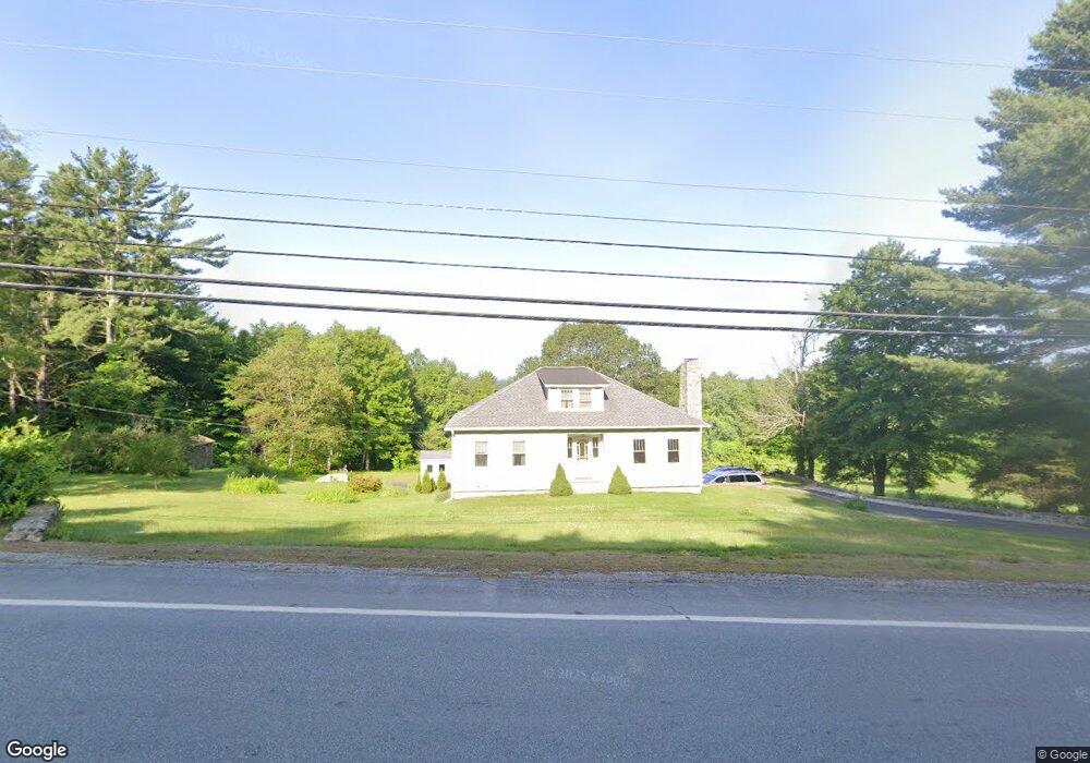
464 Londonderry Turnpike Auburn, NH 03032
Estimated Value: $568,502 - $705,000
3
Beds
2
Baths
2,128
Sq Ft
$289/Sq Ft
Est. Value
About This Home
This home is located at 464 Londonderry Turnpike, Auburn, NH 03032 and is currently estimated at $615,626, approximately $289 per square foot. 464 Londonderry Turnpike is a home located in Rockingham County with nearby schools including Auburn Village School, Pinkerton Academy, and Mont Blanc Academy.
Ownership History
Date
Name
Owned For
Owner Type
Purchase Details
Closed on
Jun 8, 1998
Sold by
Mclintock Donald C and Mclintock Donna J
Bought by
Blackwood Catherine A
Current Estimated Value
Home Financials for this Owner
Home Financials are based on the most recent Mortgage that was taken out on this home.
Original Mortgage
$120,000
Outstanding Balance
$24,007
Interest Rate
7.05%
Estimated Equity
$591,619
Create a Home Valuation Report for This Property
The Home Valuation Report is an in-depth analysis detailing your home's value as well as a comparison with similar homes in the area
Home Values in the Area
Average Home Value in this Area
Purchase History
| Date | Buyer | Sale Price | Title Company |
|---|---|---|---|
| Blackwood Catherine A | $153,000 | -- |
Source: Public Records
Mortgage History
| Date | Status | Borrower | Loan Amount |
|---|---|---|---|
| Open | Blackwood Catherine A | $25,000 | |
| Open | Blackwood Catherine A | $120,000 |
Source: Public Records
Tax History Compared to Growth
Tax History
| Year | Tax Paid | Tax Assessment Tax Assessment Total Assessment is a certain percentage of the fair market value that is determined by local assessors to be the total taxable value of land and additions on the property. | Land | Improvement |
|---|---|---|---|---|
| 2024 | $6,269 | $465,400 | $196,600 | $268,800 |
| 2023 | $5,784 | $458,700 | $196,200 | $262,500 |
| 2022 | $5,441 | $304,800 | $147,000 | $157,800 |
| 2021 | $5,529 | $304,800 | $147,000 | $157,800 |
| 2020 | $5,633 | $304,800 | $147,000 | $157,800 |
| 2019 | $5,733 | $304,800 | $147,000 | $157,800 |
| 2018 | $5,200 | $304,800 | $147,000 | $157,800 |
| 2017 | $5,421 | $256,300 | $140,900 | $115,400 |
| 2016 | $5,190 | $256,300 | $140,900 | $115,400 |
| 2015 | $5,380 | $259,800 | $144,200 | $115,600 |
| 2014 | $5,536 | $259,800 | $144,200 | $115,600 |
| 2013 | $5,089 | $259,800 | $144,200 | $115,600 |
Source: Public Records
Map
Nearby Homes
- 53 Tanglewood Dr
- #1 the Cliffs at Evergreen Dr
- 593 Cohas Ave
- 628 Megan Dr
- 612 Megan Dr
- 54 the Cliffs at Evergreen Dr
- 30 Windsor Dr
- 759 Cohas Ave
- 33 Bunker Hill Rd
- 46 Eastmeadow Way
- 3 Bellflower Hollow
- 24 Cranberry Way Unit 8
- 1345 Bodwell Rd Unit 11
- 113 Stonington Dr
- 54 Windswept Rd
- 361 Aaron Dr
- Lot 4 Lovers Ln
- 286 Aaron Dr
- 1555 Bodwell Rd Unit 54
- 1799 Bodwell Rd Unit 14