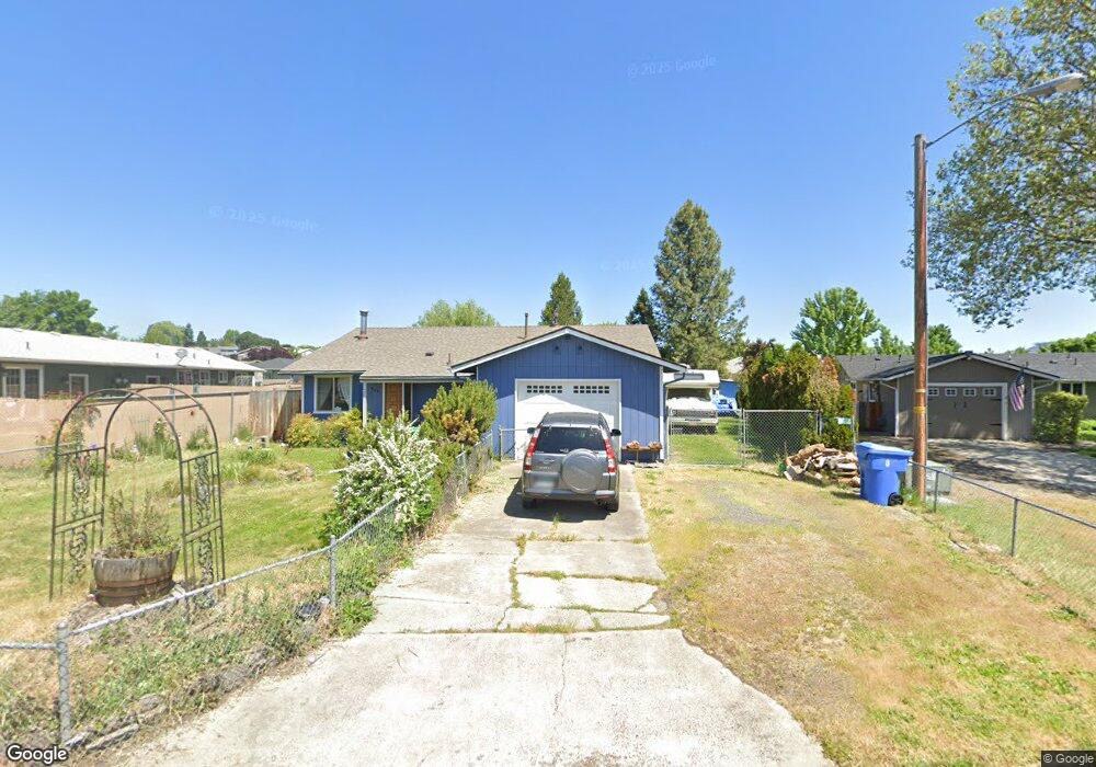
466 Laurel St Eagle Point, OR 97524
Estimated Value: $308,000 - $341,000
3
Beds
2
Baths
1,176
Sq Ft
$273/Sq Ft
Est. Value
About This Home
This home is located at 466 Laurel St, Eagle Point, OR 97524 and is currently estimated at $320,995, approximately $272 per square foot. 466 Laurel St is a home located in Jackson County with nearby schools including Eagle Rock Elementary School, Eagle Point Middle School, and White Mountain Middle School.
Ownership History
Date
Name
Owned For
Owner Type
Purchase Details
Closed on
Oct 30, 1998
Sold by
Foster Richard L
Bought by
Ellison Ronald W and Ellison Elainee M
Current Estimated Value
Home Financials for this Owner
Home Financials are based on the most recent Mortgage that was taken out on this home.
Original Mortgage
$82,500
Outstanding Balance
$16,313
Interest Rate
6.61%
Estimated Equity
$304,682
Create a Home Valuation Report for This Property
The Home Valuation Report is an in-depth analysis detailing your home's value as well as a comparison with similar homes in the area
Home Values in the Area
Average Home Value in this Area
Purchase History
| Date | Buyer | Sale Price | Title Company |
|---|---|---|---|
| Ellison Ronald W | $87,000 | Jackson County Title |
Source: Public Records
Mortgage History
| Date | Status | Borrower | Loan Amount |
|---|---|---|---|
| Open | Ellison Ronald W | $82,500 |
Source: Public Records
Tax History
| Year | Tax Paid | Tax Assessment Tax Assessment Total Assessment is a certain percentage of the fair market value that is determined by local assessors to be the total taxable value of land and additions on the property. | Land | Improvement |
|---|---|---|---|---|
| 2026 | $2,053 | $150,910 | -- | -- |
| 2025 | $2,005 | $146,520 | $78,510 | $68,010 |
| 2024 | $2,005 | $142,260 | $76,220 | $66,040 |
| 2023 | $1,937 | $138,120 | $74,000 | $64,120 |
| 2022 | $1,884 | $138,120 | $74,000 | $64,120 |
| 2021 | $1,829 | $134,100 | $71,850 | $62,250 |
| 2020 | $1,942 | $130,200 | $69,760 | $60,440 |
| 2019 | $1,913 | $122,730 | $65,760 | $56,970 |
| 2018 | $1,876 | $119,160 | $63,850 | $55,310 |
| 2017 | $1,830 | $119,160 | $63,850 | $55,310 |
| 2016 | $1,795 | $112,330 | $60,190 | $52,140 |
| 2015 | $1,736 | $112,330 | $60,190 | $52,140 |
| 2014 | $1,686 | $105,890 | $56,740 | $49,150 |
Source: Public Records
Map
Nearby Homes
- 250 Tierra Cir
- 71 Tracy Ave Unit 71 & 73
- 911 Stonewater Dr
- 917 Stonewater Dr
- 318 S Buchanan Ave
- 912 Stonewater Dr
- 403 N Deanjou Ave
- 925 Sellwood Dr
- 407 N Deanjou Ave
- 1023 Highlands Dr
- 650 Sarah Ln
- 110 Linton Way
- 426 Westminster Dr
- 620 S Royal Ave
- 438 Westminster Dr
- 407 S Shasta Ave
- 208 Northview Dr Unit 1B
- 0 Crater Lake Hwy
- 522 Meadow Ln
- 945 Win Way
- 212 Tracy Ave
- 454 Laurel St
- 487 Minerva Ave
- 495 Minerva Ct
- 495 Minerva Ave
- 495 Minerva Ave Unit 2
- 481 Minerva Ave
- 422 Laurel St
- 133137 Tracy Ave
- 477 Laurel St
- 409 Laurel St
- 48183 Minerva Ct
- 4879 Minerva Ct
- 46466 Minerva Ct
- 233 Minerva Ct
- 253 Minerva Ct
- 245 Minerva Ct
- 239 Minerva Ct
- 0 Minerva Ct
- 227 Minerva Ct
Your Personal Tour Guide
Ask me questions while you tour the home.