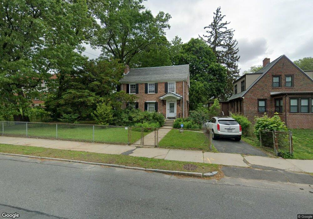
468 Alden St Springfield, MA 01109
Upper Hill NeighborhoodEstimated Value: $285,000 - $313,000
3
Beds
2
Baths
1,696
Sq Ft
$176/Sq Ft
Est. Value
About This Home
This home is located at 468 Alden St, Springfield, MA 01109 and is currently estimated at $298,803, approximately $176 per square foot. 468 Alden St is a home located in Hampden County with nearby schools including Mary A. Dryden Veterans Memorial School, M Marcus Kiley Middle, and Springfield High School of Science and Technology.
Ownership History
Date
Name
Owned For
Owner Type
Purchase Details
Closed on
Dec 13, 2013
Sold by
Scott Brenda and Scott Youvhan
Bought by
Scott Brenda G and Lott Karen N
Current Estimated Value
Purchase Details
Closed on
Oct 9, 1986
Bought by
Scott Brenda G and Lott Karen N
Create a Home Valuation Report for This Property
The Home Valuation Report is an in-depth analysis detailing your home's value as well as a comparison with similar homes in the area
Home Values in the Area
Average Home Value in this Area
Purchase History
| Date | Buyer | Sale Price | Title Company |
|---|---|---|---|
| Scott Brenda G | -- | -- | |
| Scott Brenda G | $90,000 | -- |
Source: Public Records
Mortgage History
| Date | Status | Borrower | Loan Amount |
|---|---|---|---|
| Previous Owner | Scott Brenda G | $67,000 |
Source: Public Records
Tax History
| Year | Tax Paid | Tax Assessment Tax Assessment Total Assessment is a certain percentage of the fair market value that is determined by local assessors to be the total taxable value of land and additions on the property. | Land | Improvement |
|---|---|---|---|---|
| 2025 | $4,082 | $260,300 | $32,200 | $228,100 |
| 2024 | $3,557 | $221,500 | $32,200 | $189,300 |
| 2023 | $3,599 | $211,100 | $29,300 | $181,800 |
| 2022 | $3,066 | $162,900 | $27,300 | $135,600 |
| 2021 | $3,651 | $161,400 | $19,400 | $142,000 |
| 2020 | $2,959 | $151,500 | $19,400 | $132,100 |
| 2019 | $3,454 | $151,100 | $16,500 | $134,600 |
| 2018 | $2,785 | $141,500 | $16,500 | $125,000 |
| 2017 | $2,640 | $134,300 | $15,600 | $118,700 |
| 2016 | $2,556 | $130,000 | $15,600 | $114,400 |
| 2015 | $2,539 | $129,100 | $15,600 | $113,500 |
Source: Public Records
Map
Nearby Homes
- 0 NS (24) Alden St
- 135-137 Suffolk St
- 124-126 Westford Cir
- 22 Amanda St
- 89 Bristol St
- 111 Marlborough St
- 44 Amanda St
- 21 Westford Cir
- 62-64 Bristol St
- 11 Ina St
- 189 Northampton Ave
- 87 Fenwick St
- 31-33 Suffolk St
- 283 Wilbraham Rd
- 41 Olive St
- 236 Pondview Dr
- 19 Westford Ave
- 48-50 Dresden St
- 25 Dresden St
- 118 Pilgrim Rd
- 263 Norfolk St
- 255 Norfolk St
- 251 Norfolk St
- 245 Norfolk St
- 229 Bristol St
- 241 Norfolk St
- 225 Bristol St
- 235 Norfolk St
- 220 Middlesex St Unit 222
- 221 Bristol St
- 229 Norfolk St
- 226 Norfolk St
- 216 Middlesex St
- 216 Middlesex St
- 215 Bristol St
- 522 King St Unit 524
- 225 Norfolk St
- 518 King St
- 220 Norfolk St Unit 222
- 207 Middlesex St
Your Personal Tour Guide
Ask me questions while you tour the home.