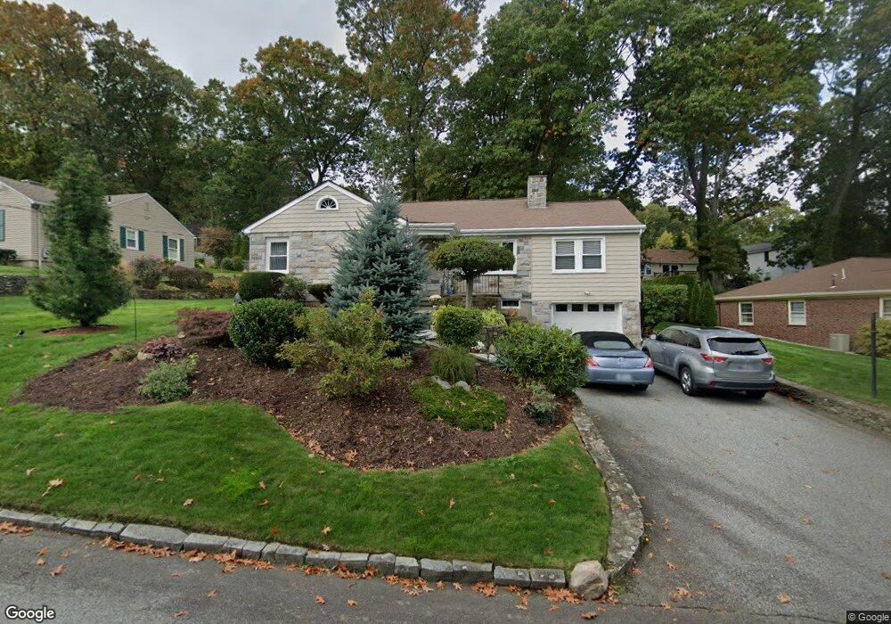
47 Bennington Rd Cranston, RI 02920
Meshanticut NeighborhoodEstimated Value: $476,594 - $589,000
3
Beds
2
Baths
1,549
Sq Ft
$340/Sq Ft
Est. Value
About This Home
This home is located at 47 Bennington Rd, Cranston, RI 02920 and is currently estimated at $527,399, approximately $340 per square foot. 47 Bennington Rd is a home located in Providence County with nearby schools including Woodridge Elementary School, Western Hills Middle School, and Cranston High School West.
Ownership History
Date
Name
Owned For
Owner Type
Purchase Details
Closed on
Mar 15, 2024
Sold by
Crouse Thomas R and Crouse Angela E
Bought by
Angela Thomas R and Angela Crouse
Current Estimated Value
Create a Home Valuation Report for This Property
The Home Valuation Report is an in-depth analysis detailing your home's value as well as a comparison with similar homes in the area
Home Values in the Area
Average Home Value in this Area
Purchase History
| Date | Buyer | Sale Price | Title Company |
|---|---|---|---|
| Angela Thomas R | -- | None Available |
Source: Public Records
Tax History
| Year | Tax Paid | Tax Assessment Tax Assessment Total Assessment is a certain percentage of the fair market value that is determined by local assessors to be the total taxable value of land and additions on the property. | Land | Improvement |
|---|---|---|---|---|
| 2025 | $5,583 | $402,200 | $144,200 | $258,000 |
| 2024 | $5,474 | $402,200 | $144,200 | $258,000 |
| 2023 | $5,547 | $293,500 | $103,200 | $190,300 |
| 2022 | $5,433 | $293,500 | $103,200 | $190,300 |
| 2021 | $5,283 | $293,500 | $103,200 | $190,300 |
| 2020 | $5,230 | $251,800 | $106,800 | $145,000 |
| 2019 | $5,230 | $251,800 | $106,800 | $145,000 |
| 2018 | $5,109 | $251,800 | $106,800 | $145,000 |
| 2017 | $5,288 | $230,500 | $99,500 | $131,000 |
| 2016 | $5,175 | $230,500 | $99,500 | $131,000 |
| 2015 | $5,175 | $230,500 | $99,500 | $131,000 |
| 2014 | $4,549 | $230,500 | $106,800 | $123,700 |
Source: Public Records
Map
Nearby Homes
- 242 Brettonwoods Dr
- 141 Glen Ridge Rd
- 29 Poppy Dr
- 275 Meshanticut Valley Pkwy
- 214 Meshanticut Valley Pkwy
- 51 E Bel Air Rd
- 55 Cypress Dr
- 58 Meredith Dr
- 24 Elm Cir
- 11 W Blue Ridge Rd
- 175 Hoffman Ave Unit 102
- 12 Coldbrook Ct
- 210 Summit Dr
- 203 Dean Ridge Ct
- 57 Delway Rd
- 105 Coldbrook Dr
- 7 Oak Tree Ln
- 38 Baldino Dr
- 321 Budlong Rd
- 84 Intervale Rd
- 33 Bennington Rd
- 51 Bennington Rd
- 45 Deerfield Rd
- 53 Deerfield Rd
- 48 Bennington Rd
- 40 Bennington Rd
- 27 Bennington Rd
- 59 Bennington Rd
- 54 Bennington Rd
- 34 Bennington Rd
- 59 Deerfield Rd
- 62 Bennington Rd
- 30 Bennington Rd
- 31 Deerfield Rd
- 19 Bennington Rd
- 67 Bennington Rd
- 42 Deerfield Rd
- 5 Dean Pkwy
- 52 Deerfield Rd
- 17 Dean Pkwy
Your Personal Tour Guide
Ask me questions while you tour the home.