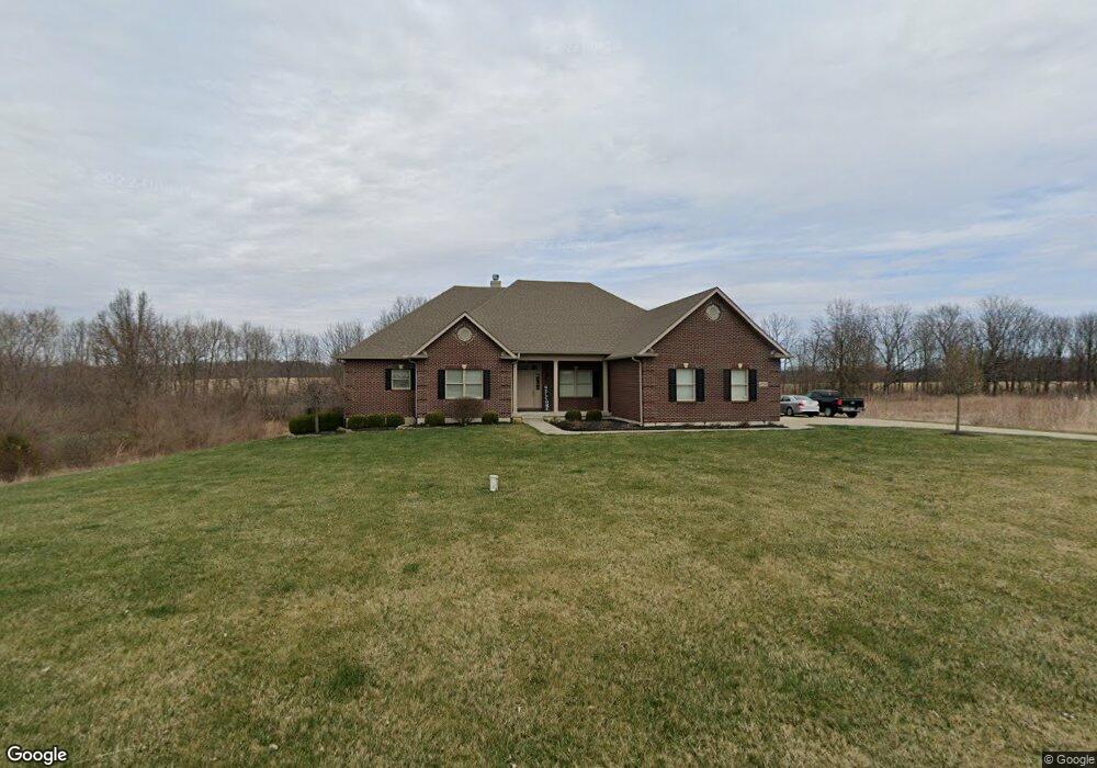
4736 Sullivan Rd Springfield, OH 45502
Estimated Value: $556,000 - $612,000
4
Beds
4
Baths
2,890
Sq Ft
$203/Sq Ft
Est. Value
About This Home
This home is located at 4736 Sullivan Rd, Springfield, OH 45502 and is currently estimated at $585,285, approximately $202 per square foot. 4736 Sullivan Rd is a home located in Clark County with nearby schools including Greenon Elementary School, Greenon Jr. High School, and Greenon High School.
Ownership History
Date
Name
Owned For
Owner Type
Purchase Details
Closed on
Jun 5, 2024
Sold by
Spahr Karl W and Spahr Ammie Y
Bought by
Mcmillin Theodore Scott and Mcmillin Ricki L
Current Estimated Value
Purchase Details
Closed on
Sep 9, 2008
Sold by
American Residential Construction Inc
Bought by
Spahr Karl W and Spahr Ammie Y
Home Financials for this Owner
Home Financials are based on the most recent Mortgage that was taken out on this home.
Original Mortgage
$418,000
Interest Rate
6.12%
Mortgage Type
Purchase Money Mortgage
Purchase Details
Closed on
Aug 20, 2007
Sold by
Spahr Karl W and Spahr Ammie Y
Bought by
American Residential Construction Inc
Purchase Details
Closed on
Jan 22, 2007
Sold by
Echo Hills V Llc
Bought by
Spahr Karl W and Spahr Ammie Y
Create a Home Valuation Report for This Property
The Home Valuation Report is an in-depth analysis detailing your home's value as well as a comparison with similar homes in the area
Purchase History
| Date | Buyer | Sale Price | Title Company |
|---|---|---|---|
| Mcmillin Theodore Scott | $585,000 | City Title | |
| Mcmillin Theodore Scott | $585,000 | City Title | |
| Spahr Karl W | $465,000 | Attorney | |
| American Residential Construction Inc | $65,000 | None Available | |
| Spahr Karl W | $65,000 | Rels Title |
Source: Public Records
Mortgage History
| Date | Status | Borrower | Loan Amount |
|---|---|---|---|
| Previous Owner | Spahr Karl W | $418,000 |
Source: Public Records
Tax History
| Year | Tax Paid | Tax Assessment Tax Assessment Total Assessment is a certain percentage of the fair market value that is determined by local assessors to be the total taxable value of land and additions on the property. | Land | Improvement |
|---|---|---|---|---|
| 2025 | $7,516 | $196,010 | $26,240 | $169,770 |
| 2024 | $7,338 | $140,310 | $22,600 | $117,710 |
| 2023 | $7,338 | $140,310 | $22,600 | $117,710 |
| 2022 | $7,331 | $140,310 | $22,600 | $117,710 |
| 2021 | $7,191 | $121,880 | $18,380 | $103,500 |
| 2020 | $7,210 | $121,880 | $18,380 | $103,500 |
| 2019 | $7,308 | $121,880 | $18,380 | $103,500 |
| 2018 | $6,181 | $100,910 | $18,380 | $82,530 |
| 2017 | $6,195 | $128,832 | $18,375 | $110,457 |
| 2016 | $5,399 | $128,832 | $18,375 | $110,457 |
| 2015 | $6,607 | $128,832 | $18,375 | $110,457 |
| 2014 | $6,620 | $128,832 | $18,375 | $110,457 |
| 2013 | $5,823 | $128,832 | $18,375 | $110,457 |
Source: Public Records
Map
Nearby Homes
- 3864 Quailhollow Ct
- 5152 S Tecumseh Rd
- 1010 Meadow Lark Dr
- 2925 S Tecumseh Rd
- 4538 Cynthia Dr
- 4200 Phillips St
- 199 Fairfield Pike
- 41 W Hunter Dr
- 3628-3642 Charlotte Dr
- 3644-3650 Charlotte Dr
- 3611-3625 Charlotte Dr
- 6250 Fairfield Pike
- 6788 Ginger Ave
- 141 N Xenia Dr
- 4311 Lone Wolf Ave
- 6937 Tall Timber Trail
- 3190 Rebert Pike
- 5463 Enon-Xenia Rd
- Tract 2 W Jackson Rd
- 0 Enon-Xenia Rd
- 4708 Sullivan Rd
- 4741 Sullivan Rd
- 4780 Sullivan Rd
- 4685 Sullivan Rd
- 4777 Sullivan Rd
- 4663 Sullivan Rd
- 4646 Sullivan Rd
- 4798 Sullivan Rd
- 4799 Sullivan Rd
- 4641 Sullivan Rd
- 4641 Sullivan Rd
- 4865 Rebert Pike
- 4618 Sullivan Rd
- 4615 Sullivan Ave
- 4738 Jeremy Ave
- 4615 Sullivan Rd
- 4800 Sullivan Ave
- 4642 Jeremy Ave
- 4584 Sullivan Rd
- 4782 Jeremy Ave
Your Personal Tour Guide
Ask me questions while you tour the home.