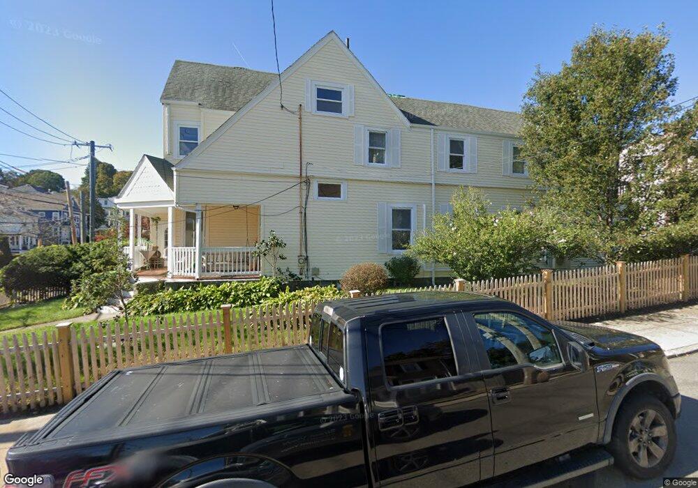
475 Poplar St Unit 1 Roslindale, MA 02131
Roslindale NeighborhoodEstimated Value: $857,000 - $964,000
4
Beds
2
Baths
2,157
Sq Ft
$418/Sq Ft
Est. Value
About This Home
This home is located at 475 Poplar St Unit 1, Roslindale, MA 02131 and is currently estimated at $901,575, approximately $417 per square foot. 475 Poplar St Unit 1 is a home located in Suffolk County with nearby schools including Brooke Charter School Roslindale, Sacred Heart STEM School, and St. Clare High School.
Ownership History
Date
Name
Owned For
Owner Type
Purchase Details
Closed on
Aug 29, 2008
Sold by
Adams Christine E and Adams Mark R
Bought by
Berson Jessica and Mcdonald Matthew
Current Estimated Value
Purchase Details
Closed on
Sep 29, 2006
Sold by
Sabatino Robert S
Bought by
Adams Christine E and Adams Mark R
Purchase Details
Closed on
May 15, 1997
Sold by
Poplar Street Rt 475
Bought by
Sabatino Robert S
Purchase Details
Closed on
Mar 15, 1996
Sold by
Walsh John F Est
Bought by
Poplar St Rt
Create a Home Valuation Report for This Property
The Home Valuation Report is an in-depth analysis detailing your home's value as well as a comparison with similar homes in the area
Home Values in the Area
Average Home Value in this Area
Purchase History
| Date | Buyer | Sale Price | Title Company |
|---|---|---|---|
| Berson Jessica | $389,000 | -- | |
| Adams Christine E | $393,000 | -- | |
| Sabatino Robert S | $156,500 | -- | |
| Poplar St Rt | $72,000 | -- |
Source: Public Records
Mortgage History
| Date | Status | Borrower | Loan Amount |
|---|---|---|---|
| Open | Poplar St Rt | $300,000 | |
| Closed | Poplar St Rt | $307,000 |
Source: Public Records
Tax History Compared to Growth
Tax History
| Year | Tax Paid | Tax Assessment Tax Assessment Total Assessment is a certain percentage of the fair market value that is determined by local assessors to be the total taxable value of land and additions on the property. | Land | Improvement |
|---|---|---|---|---|
| 2025 | $8,370 | $722,800 | $238,200 | $484,600 |
| 2024 | $7,682 | $704,800 | $249,500 | $455,300 |
| 2023 | $7,071 | $658,400 | $233,100 | $425,300 |
| 2022 | $6,635 | $609,800 | $215,900 | $393,900 |
| 2021 | $6,081 | $569,900 | $207,600 | $362,300 |
| 2020 | $5,965 | $564,900 | $201,200 | $363,700 |
| 2019 | $5,668 | $537,800 | $161,300 | $376,500 |
| 2018 | $5,367 | $512,100 | $161,300 | $350,800 |
| 2017 | $5,118 | $483,300 | $161,300 | $322,000 |
| 2016 | $4,877 | $443,400 | $161,300 | $282,100 |
| 2015 | $4,867 | $401,900 | $145,200 | $256,700 |
| 2014 | $4,593 | $365,100 | $145,200 | $219,900 |
Source: Public Records
Map
Nearby Homes
- 15 Cornell St
- 273 Metropolitan Ave Unit 2
- 75 Glendower Rd
- 415 Poplar St
- 417 Poplar St
- 89 Glendower Rd
- 67 Hautevale St
- 23 Weeks Ave
- 5 7 Hemman St
- 124 Glendower Rd Unit 2
- 142 Metropolitan Ave Unit A
- 25 Pinedale Rd Unit 1
- 68 Asheville Rd
- 619 Poplar St
- 15 Beechmont Terrace
- 25 Crandall St
- 69 Metropolitan Ave
- 16 Hilburn Place
- 55 Metropolitan Ave
- 175 Clare Ave Unit B3
- 475 Poplar St
- 479 Poplar St
- 8 Cornell St
- 7 Cornell St
- 12 Cornell St
- 483 Poplar St
- 11 Cornell St
- 467 Poplar St
- 16 Cornell St
- 463 Poplar St
- 1 Dale St
- 485 Poplar St
- 44 Chisholm Rd
- 15 Glendower Rd
- 459 Poplar St
- 20 Cornell St
- 490 Poplar St Unit 492
- 490 Poplar St Unit 2nd Flr
- 490 Poplar St
- 490 Poplar St Unit 2