Estimated Value: $522,675 - $638,000
4
Beds
3
Baths
2,826
Sq Ft
$205/Sq Ft
Est. Value
About This Home
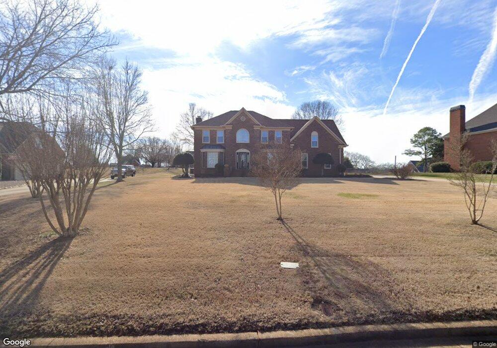
This home is located at 479 Meathward Cir, Moore, SC 29369 and is currently estimated at $578,558, approximately $204 per square foot. 479 Meathward Cir is a home located in Spartanburg County with nearby schools including Dorman High School Freshman Campus, Dorman High School, and GREEN Charter School Spartanburg.
Ownership History
Date
Name
Owned For
Owner Type
Purchase Details
Closed on
Sep 27, 2023
Sold by
Butler James E
Bought by
James And Carolyn Butler Family Trust and Butler
Current Estimated Value
Purchase Details
Closed on
Mar 18, 2016
Sold by
Butler James E and Butler Carolyn V
Bought by
Butler James E and Butller Carolyn
Purchase Details
Closed on
Feb 20, 2008
Sold by
Holmes Rita Kay and Holmes Robin M
Bought by
Butler James E and Butler Carolyn
Home Financials for this Owner
Home Financials are based on the most recent Mortgage that was taken out on this home.
Original Mortgage
$147,950
Interest Rate
5.46%
Mortgage Type
Unknown
Create a Home Valuation Report for This Property
The Home Valuation Report is an in-depth analysis detailing your home's value as well as a comparison with similar homes in the area
Home Values in the Area
Average Home Value in this Area
Purchase History
| Date | Buyer | Sale Price | Title Company |
|---|---|---|---|
| James And Carolyn Butler Family Trust | -- | None Listed On Document | |
| Butler James E | -- | None Available | |
| Butler James E | $295,900 | Capital Title Agency |
Source: Public Records
Mortgage History
| Date | Status | Borrower | Loan Amount |
|---|---|---|---|
| Previous Owner | Butler James E | $147,950 |
Source: Public Records
Tax History
| Year | Tax Paid | Tax Assessment Tax Assessment Total Assessment is a certain percentage of the fair market value that is determined by local assessors to be the total taxable value of land and additions on the property. | Land | Improvement |
|---|---|---|---|---|
| 2022 | $2,009 | $13,360 | $1,800 | $11,560 |
| 2021 | $2,009 | $13,360 | $1,800 | $11,560 |
| 2020 | $1,962 | $13,360 | $1,800 | $11,560 |
| 2019 | $1,945 | $13,360 | $1,800 | $11,560 |
| 2018 | $1,928 | $13,360 | $1,800 | $11,560 |
| 2017 | $1,716 | $12,280 | $1,800 | $10,480 |
| 2016 | $1,680 | $12,280 | $1,800 | $10,480 |
| 2015 | $1,697 | $12,280 | $1,800 | $10,480 |
| 2014 | $1,645 | $12,280 | $1,800 | $10,480 |
Source: Public Records
Map
Nearby Homes
- 123 Blairfield Ct
- 287 Antrim Ave
- 317 E Killarney Lake
- 169 Nicholls Dr
- 641 Monfret Ct
- 108 Kirkwood Dr
- 105 Pimmitt Run
- 105 Pimmit Run
- 759 Rodin Rd
- 767 Rodin Rd
- 789 Baker Way
- 631 Monfret Ct
- 617 Monfret Ct
- 101 Stockton Ln
- 607 Monfret Ct
- 230 Donegal Dr
- 507 Thornhill Dr
- 00 Reidville
- 207 Woodgrove Trace
- 410 Thornhill Dr
- 309 Meathward Cir
- 475 Meathward Cir
- 471 Meathward Cir
- 317 Meathward Cir
- 110 W Killarney Lake
- 327 Meathward Cir
- 131 Blairfield Ct
- 111 W Killarney Lake
- 463 Meathward Cir
- 474 Meathward Cir
- 337 Meathward Cir
- 127 Blairfield Ct
- 310 Meathward Cir
- 130 Blairfield Ct
- 314 Meathward Cir
- 470 Meathward Cir
- 459 Meathward Cir
- 318 Meathward Cir
- 111 Antrim Ave
- 117 Antrim Ave
Your Personal Tour Guide
Ask me questions while you tour the home.