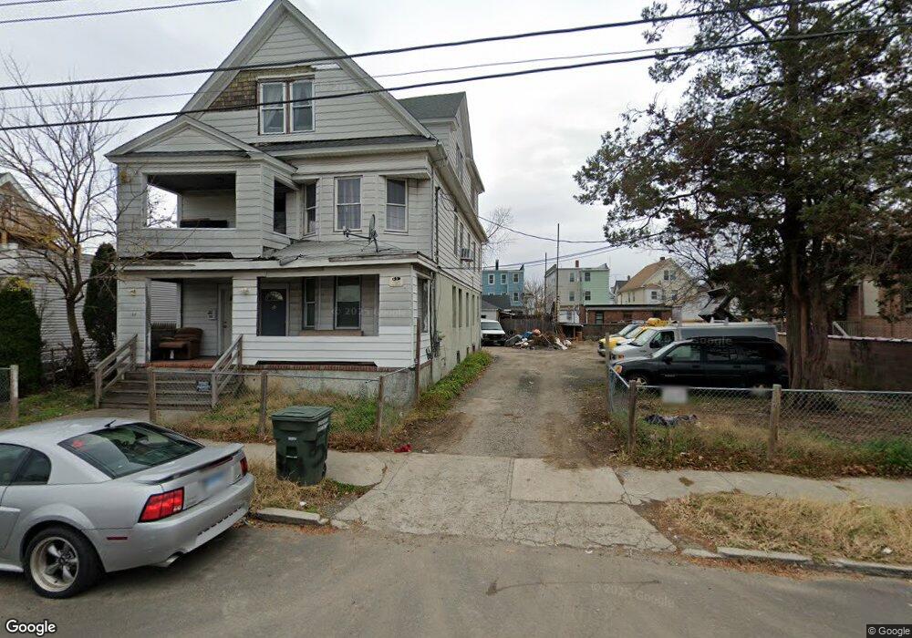
48-52 Beers St Bridge Port, CT 06606
Brooklawn-Saint Vincent NeighborhoodEstimated Value: $334,318 - $725,000
6
Beds
3
Baths
3,506
Sq Ft
$159/Sq Ft
Est. Value
About This Home
This home is located at 48-52 Beers St, Bridge Port, CT 06606 and is currently estimated at $559,080, approximately $159 per square foot. 48-52 Beers St is a home located in Fairfield County with nearby schools including Read School, Central High School, and Catholic Academy of Bridgeport-St. Raphael Academy.
Ownership History
Date
Name
Owned For
Owner Type
Purchase Details
Closed on
Nov 29, 2001
Sold by
Andronescu Nicole
Bought by
Alves-Dossantos A and Alves-Dossantos Marcia
Current Estimated Value
Home Financials for this Owner
Home Financials are based on the most recent Mortgage that was taken out on this home.
Original Mortgage
$123,900
Interest Rate
11.13%
Create a Home Valuation Report for This Property
The Home Valuation Report is an in-depth analysis detailing your home's value as well as a comparison with similar homes in the area
Home Values in the Area
Average Home Value in this Area
Purchase History
| Date | Buyer | Sale Price | Title Company |
|---|---|---|---|
| Alves-Dossantos A | $154,900 | -- |
Source: Public Records
Mortgage History
| Date | Status | Borrower | Loan Amount |
|---|---|---|---|
| Open | Alves-Dossantos A | $262,000 | |
| Closed | Alves-Dossantos A | $210,800 | |
| Closed | Alves-Dossantos A | $123,900 |
Source: Public Records
Tax History Compared to Growth
Tax History
| Year | Tax Paid | Tax Assessment Tax Assessment Total Assessment is a certain percentage of the fair market value that is determined by local assessors to be the total taxable value of land and additions on the property. | Land | Improvement |
|---|---|---|---|---|
| 2025 | $6,950 | $159,960 | $71,690 | $88,270 |
| 2024 | $6,950 | $159,960 | $71,690 | $88,270 |
| 2023 | $6,950 | $159,960 | $71,690 | $88,270 |
| 2022 | $6,950 | $159,960 | $71,690 | $88,270 |
| 2021 | $7,050 | $162,250 | $71,690 | $90,560 |
| 2020 | $7,987 | $147,940 | $43,420 | $104,520 |
| 2019 | $7,987 | $147,940 | $43,420 | $104,520 |
| 2018 | $8,043 | $147,940 | $43,420 | $104,520 |
| 2017 | $8,043 | $147,940 | $43,420 | $104,520 |
| 2016 | $8,043 | $147,940 | $43,420 | $104,520 |
| 2015 | $7,986 | $189,230 | $43,790 | $145,440 |
| 2014 | $7,986 | $189,230 | $43,790 | $145,440 |
Source: Public Records
Map
Nearby Homes
- 90 Tom Thumb St
- 78 Fairmount Ave
- 390 Charles St Unit 106
- 76 Porter St
- 31 Taft Ave
- 2395 Main St Unit 2397
- 724 Capitol Ave Unit 726
- 119 Madison Terrace
- 191 Oak St
- 318 Center St
- 330 French St
- 356 Taft Ave
- 100 Lorraine St
- 508 Hawley Ave
- 183 Calhoun Ave
- 201 High Ridge Dr
- 1275 Capitol Ave
- 139 Highland Ave Unit 143
- 152 River St
- 2345 Park Ave
- 72 Beers St
- 48 Beers St Unit 52
- 82 Beers St Unit 86
- 80 Beers St
- 83 Alice St
- 86 Beers St
- 75 Alice St
- 107 Alice St
- 89 Alice St Unit 93
- 67 Alice St
- 35 Beers St Unit 206
- 35 Beers St Unit 1st Flr
- 35 Beers St Unit 104
- 35 Beers St
- 35 Beers St Unit 306
- 35 Beers St Unit 304
- 35 Beers St Unit 105
- 96 Beers St
- 57 Alice St
- 113 Alice St