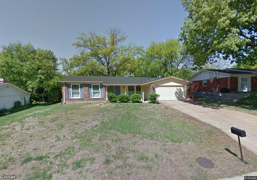
4807 Morestead Dr Saint Louis, MO 63128
Estimated Value: $293,186 - $329,000
3
Beds
2
Baths
1,386
Sq Ft
$231/Sq Ft
Est. Value
About This Home
This home is located at 4807 Morestead Dr, Saint Louis, MO 63128 and is currently estimated at $319,547, approximately $230 per square foot. 4807 Morestead Dr is a home located in St. Louis County with nearby schools including Kennerly Elementary School, Sperreng Middle School, and Lindbergh High School.
Ownership History
Date
Name
Owned For
Owner Type
Purchase Details
Closed on
Jun 7, 2002
Sold by
Braun Edward S and Braun Marilyn S
Bought by
Kuntz Kenneth L and Kuntz Tanya E
Current Estimated Value
Home Financials for this Owner
Home Financials are based on the most recent Mortgage that was taken out on this home.
Original Mortgage
$153,800
Outstanding Balance
$64,846
Interest Rate
6.77%
Estimated Equity
$254,701
Purchase Details
Closed on
May 10, 2002
Sold by
Escoffery Richard F and Escoffery Margaret R
Bought by
Helix Realty Inc
Home Financials for this Owner
Home Financials are based on the most recent Mortgage that was taken out on this home.
Original Mortgage
$153,800
Outstanding Balance
$64,846
Interest Rate
6.77%
Estimated Equity
$254,701
Create a Home Valuation Report for This Property
The Home Valuation Report is an in-depth analysis detailing your home's value as well as a comparison with similar homes in the area
Home Values in the Area
Average Home Value in this Area
Purchase History
| Date | Buyer | Sale Price | Title Company |
|---|---|---|---|
| Kuntz Kenneth L | $161,900 | -- | |
| Helix Realty Inc | -- | -- |
Source: Public Records
Mortgage History
| Date | Status | Borrower | Loan Amount |
|---|---|---|---|
| Open | Kuntz Kenneth L | $153,800 | |
| Previous Owner | Helix Realty Inc | $161,500 |
Source: Public Records
Tax History
| Year | Tax Paid | Tax Assessment Tax Assessment Total Assessment is a certain percentage of the fair market value that is determined by local assessors to be the total taxable value of land and additions on the property. | Land | Improvement |
|---|---|---|---|---|
| 2025 | $3,274 | $50,520 | $14,570 | $35,950 |
| 2024 | $3,274 | $50,250 | $14,570 | $35,680 |
| 2023 | $3,266 | $50,250 | $14,570 | $35,680 |
| 2022 | $2,941 | $43,390 | $14,570 | $28,820 |
| 2021 | $2,837 | $43,390 | $14,570 | $28,820 |
| 2020 | $2,297 | $33,820 | $14,570 | $19,250 |
| 2019 | $2,291 | $33,820 | $14,570 | $19,250 |
| 2018 | $2,213 | $29,700 | $8,890 | $20,810 |
| 2017 | $2,189 | $29,700 | $8,890 | $20,810 |
| 2016 | $2,140 | $27,570 | $8,090 | $19,480 |
Source: Public Records
Map
Nearby Homes
- 4767 Towne South Rd
- 4839 Hursley Dr
- 5108 Kennerly Place Dr Unit 7A
- 105 Worthington Cir Unit 34
- 4988 Sefton Dr
- 12430 Somerset Place Dr
- 12586 Chardin Place Unit 4
- 12568 Chardin Place Unit 1
- 4930 Mount Royal Rd
- 4931 Butler Hill Rd
- 16 Bayswater Rd
- 12055 Charwick Dr
- 4931 Theiss Rd
- 5334 Tesson Ct
- 5325 Tesson Gardens Ct
- 5333 Tesson Ct
- 10239 Hartshill Ln
- 4662 Britcastle Dr
- 4540 Butler Hill Rd
- 10008 Meadowfield Ln
- 4815 Morestead Dr
- 4801 Morestead Dr
- 4810 Holmeswood Ct
- 4800 Holmeswood Ct
- 4821 Morestead Dr
- 4808 Morestead Dr
- 4824 Holmeswood Ct
- 4914 Sherborne Dr
- 4827 Morestead Dr
- 4822 Morestead Dr
- 4925 Sherborne Dr
- 4811 Towne South Rd
- 4817 Holmeswood Ct
- 4830 Holmeswood Ct
- 4809 Holmeswood Ct
- 4904 Sherborne Dr
- 4917 Sherborne Dr
- 4823 Holmeswood Ct
- 4931 Sherborne Dr
- 4817 Towne South Rd
Your Personal Tour Guide
Ask me questions while you tour the home.